Voyage details and related metadata, reports, events and data.
FR 03/96
(alternative identifier: FR199603)
- is a Marine National Facility ![]() voyage
voyage
Period: 1996-03-07 00:00 to 1996-03-21 00:00 Local
Duration: 14.00 days
From: Dampier To: Dampier
Region: NW Shelf, WA
Ship: Franklin [details]
Description: Cruise FR 03/96 was undertaken to determine the nature of sedimentation in the Northwest Shelf around the Rowley Shoals, Scott Reef and Ashmore Reef during the last glacial maximum. Survey methods included gravity and vibra cores, grabs, SCUBA dives, CTDs, ADCP and underway instrumentation. Data, water, sediments, coral and shell samples were collected for on board and laboratory analyses.
Leader: B. Opdyke (ANU)
Project: National Facility External Users: B. Opdyke (ANU Geology Dept.) [details]
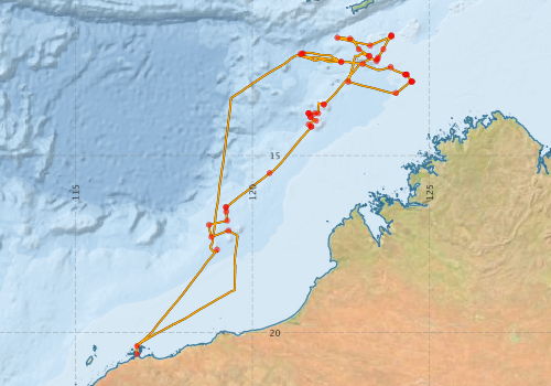
Voyage extents: 20° 36.2' S to 11° 36.1' S 116° 42.9' E to 124° 30.3' E Get voyage track shapefile Get CSV
Marlin Metadata:-
Participants - on ship:-
| Name | Role | Organisation |
|---|---|---|
| Bradley Opdyke | Chief Investigator | Australian National University |
| Damien Kelleher | Australian National University | |
| Dave Vaudrey | CSIRO ORV | |
| Kriton Glenn | Australian National University | |
| Michael Wilson | Australian National University | |
| Norm Frasier | Australian National University | |
| Phil Adams | CSIRO ORV | |
| Val Latham | CSIRO ORV | |
| Yusuke Yokoyama | Australian National University |
This list includes those that may have only been on part of the voyage. See voyage reports on 'Reports and Maps' tab for details.
Marine National Facility Reports - plans, summaries and data processing
-
FR199603 Voyage Summary
- includes preliminary results, voyage narrative, types of data collected with C77/ROSCOP codes.
-
FR199603 Voyage Plan
- includes objectives, investigator details, proposed data collection, voyage track and equipment to be used.
-

Search for publications, reports and datasets from this and other voyages
Data publishing
This is a list of online datasets hosted by CSIRO. Other processed datasets hosted by collaborating organisations may be found on the 'Metadata' or "Reports, Publications and Maps' tab.
Use the Get data link on the right to extract data using the NCMI Data Trawler.
| Data Stream | Data Summary | Get data | ||||||||||||||
|---|---|---|---|---|---|---|---|---|---|---|---|---|---|---|---|---|
| ADCP Data |
|
Get Data from Trawler Download ASCII dataset - fr9603adcp.zip Download NetCDF dataset - fr9603adcpCDF.zip Download Processing Report - fr9603adcp.pdf |
||||||||||||||
| CTD profile |
|
Get Data from Trawler |
||||||||||||||
| Hydrology |
|
Get Data from Trawler |
||||||||||||||
| Underway |
|
Get Data from Trawler |
Deployments by start time:- Click on column header to sort. Use link on 'Deployment' to see full details. Use the CSV button at the bottom to export data (tab delimited).
Search for deployments from this voyage and others
| Deployment | Operation | Station | Cast | Gear | Project | Start and end times | Start Location | End Location | Depth range | Max Depth | Description | |||
|---|---|---|---|---|---|---|---|---|---|---|---|---|---|---|
| Underway System [details] | Simrad EA500 Echosounder,ThermoSalinoGraph (TSG),ThermoSalinoGraph (TSG) | 105 | 1996-03-07 00:00 | 1996-03-20 23:00 | -20.6042 | 116.7420 | -20.5103 | 116.7290 | ||||||
| ADCP Data [details] | RDI VM-150 Acoustic Doppler current profiler | 105 | 1996-03-07 01:40 | 1996-03-20 20:40 | -20.3810 | 116.7410 | -20.3880 | 116.7310 | 408.8 | |||||
| CTD Cast [details] | 1 | Cast 1 | 105 | 1996-03-07 21:12 | 1996-03-07 21:27 | -17.6565 | 118.9942 | -17.6577 | 118.9937 | 0 | ||||
| CTD Cast / Hydrology [details] | 1 | Cast 2 | 105 | 1996-03-11 07:57 | 1996-03-11 09:08 | -12.1155 | 121.4322 | -12.1245 | 121.4075 | 0 | ||||
| CTD Cast / Hydrology [details] | 1 | Cast 3 | 105 | 1996-03-11 09:39 | 1996-03-11 10:45 | -12.1295 | 121.3975 | -12.1340 | 121.3765 | 0 | ||||
| CTD Cast / Hydrology [details] | 1 | Cast 4 | 105 | 1996-03-11 11:21 | 1996-03-11 13:59 | -12.1347 | 121.3620 | -12.1567 | 121.3413 | 0 | ||||
| CTD Cast / Hydrology [details] | 1 | Cast 5 | 105 | 1996-03-12 03:38 | 1996-03-12 04:32 | -12.3612 | 122.5057 | -12.3702 | 122.5173 | 0 | ||||
| CTD Cast / Hydrology [details] | 1 | Cast 6 | 105 | 1996-03-12 09:43 | 1996-03-12 10:16 | -12.4177 | 123.1125 | -12.4167 | 123.1137 | 0 | ||||
| CTD Cast / Hydrology [details] | 1 | Cast 7 | 105 | 1996-03-12 19:41 | 1996-03-12 19:55 | -12.7175 | 124.3178 | -12.7170 | 124.3162 | 0 | ||||
| CTD Cast / Hydrology [details] | 1 | Cast 8 | 105 | 1996-03-13 00:03 | 1996-03-13 00:15 | -12.9160 | 124.5003 | -12.9140 | 124.5030 | 0 | ||||
| CTD Cast / Hydrology [details] | 1 | Cast 9 | 105 | 1996-03-15 07:59 | 1996-03-15 08:09 | -12.1933 | 123.2932 | -12.1935 | 123.2917 | 0 | ||||
| CTD Cast / Hydrology [details] | 1 | Cast 10 | 105 | 1996-03-15 10:47 | 1996-03-15 11:11 | -12.0002 | 123.0005 | -12.0007 | 122.9995 | 0 | ||||
| CTD Cast / Hydrology [details] | 1 | Cast 11 | 105 | 1996-03-15 17:01 | 1996-03-15 18:23 | -11.6740 | 122.3962 | -11.6813 | 122.3727 | 0 | ||||
| CTD Cast / Hydrology [details] | 1 | Cast 12 | 105 | 1996-03-16 02:24 | 1996-03-16 02:38 | -11.8958 | 123.3202 | -11.8968 | 123.3202 | 0 | ||||
| CTD Cast / Hydrology [details] | 1 | Cast 13 | 105 | 1996-03-16 08:30 | 1996-03-16 08:46 | -11.6347 | 123.9217 | -11.6327 | 123.9208 | 0 | ||||
| CTD Cast / Hydrology [details] | 1 | Cast 14 | 105 | 1996-03-17 03:29 | 1996-03-17 04:05 | -13.5632 | 122.0162 | -13.5648 | 122.0195 | 0 | ||||
| CTD Cast / Hydrology [details] | 1 | Cast 15 | 105 | 1996-03-17 09:21 | 1996-03-17 09:58 | -13.8122 | 121.8500 | -13.8090 | 121.8497 | 0 | ||||
| CTD Cast / Hydrology [details] | 1 | Cast 16 | 105 | 1996-03-17 12:34 | 1996-03-17 14:06 | -13.8157 | 121.5833 | -13.8077 | 121.5885 | 0 | ||||
| CTD Cast / Hydrology [details] | 1 | Cast 17 | 105 | 1996-03-17 15:14 | 1996-03-17 16:14 | -13.8053 | 121.5813 | -13.8085 | 121.5840 | 0 | ||||
| CTD Cast / Hydrology [details] | 1 | Cast 18 | 105 | 1996-03-17 18:48 | 1996-03-17 19:26 | -13.9157 | 121.6338 | -13.9118 | 121.6265 | 0 | ||||
| CTD Cast / Hydrology [details] | 1 | Cast 19 | 105 | 1996-03-17 21:49 | 1996-03-17 22:27 | -14.0208 | 121.7982 | -14.0182 | 121.8013 | 0 | ||||
| CTD Cast / Hydrology [details] | 1 | Cast 20 | 105 | 1996-03-18 03:30 | 1996-03-18 04:19 | -14.1855 | 121.6593 | -14.1872 | 121.6573 | 0 | ||||
| CTD Cast / Hydrology [details] | 1 | Cast 21 | 105 | 1996-03-18 14:47 | 1996-03-18 15:21 | -15.4940 | 120.4830 | -15.4975 | 120.4823 | 0 | ||||
| CTD Cast / Hydrology [details] | 1 | Cast 22 | 105 | 1996-03-19 00:34 | 1996-03-19 01:27 | -16.4558 | 119.2498 | -16.4510 | 119.2423 | 0 | ||||
| CTD Cast / Hydrology [details] | 1 | Cast 23 | 105 | 1996-03-19 11:46 | 1996-03-19 12:16 | -17.2972 | 118.8388 | -17.2990 | 118.8405 | 0 | ||||
| Sediment Sampling [details] | 0396/21GC14 | 105 | 2007-02-08 00:00 | -11.6045 | 123.9212 | |||||||||
| Sediment Sampling [details] | 0396/06GC06 | 105 | 2007-02-08 00:00 | -12.3547 | 122.5025 | |||||||||
| Sediment Sampling [details] | 0396/43GC30 | 105 | 2007-02-08 00:00 | -17.1187 | 119.3187 | |||||||||
| Sediment Sampling [details] | 0396/35GC22 | 105 | 2007-02-08 00:00 | -14.1865 | 121.6613 | |||||||||
| Sediment Sampling [details] | 0396/31GC18 | 105 | 2007-02-08 00:00 | -13.8045 | 121.5852 | |||||||||
| Sediment Sampling [details] | 0396/32GC19 | 105 | 2007-02-08 00:00 | -13.9202 | 121.6457 | |||||||||
| Sediment Sampling [details] | 0396/40GC27 | 105 | 2007-02-08 00:00 | -16.9552 | 118.7695 | |||||||||
| Sediment Sampling [details] | 0396/39GC26 | 105 | 2007-02-08 00:00 | -16.8347 | 119.2823 | |||||||||
| Sediment Sampling [details] | 0396/38GC25 | 105 | 2007-02-08 00:00 | -16.5883 | 119.2598 | |||||||||
| Sediment Sampling [details] | 0396/37GC24 | 105 | 2007-02-08 00:00 | -16.4610 | 119.2497 | |||||||||
| Sediment Sampling [details] | 0396/34AGC21 | 105 | 2007-02-08 00:00 | -14.1283 | 121.5843 | |||||||||
| Sediment Sampling [details] | 0396/30GC17 | 105 | 2007-02-08 00:00 | -13.8128 | 121.7575 | |||||||||
| Sediment Sampling [details] | 0396/18GC12 | 105 | 2007-02-08 00:00 | -11.7045 | 122.7550 | |||||||||
| Sediment Sampling [details] | 0396/13GC07 | 105 | 2007-02-08 00:00 | -13.2385 | 124.0512 | |||||||||
| Sediment Sampling [details] | 0396/16GC10 | 105 | -12.1915 | 123.2948 | ||||||||||
| Sediment Sampling [details] | 0396/27GR14 | 105 | -13.5617 | 122.0143 | ||||||||||
| Sediment Sampling [details] | 0396/25GR13 | 105 | -12.3310 | 123.5000 | ||||||||||
| Sediment Sampling [details] | 0396/24GR12 | 105 | -12.2853 | 123.5217 | ||||||||||
| Sediment Sampling [details] | 0396/23GR11 | 105 | -12.2417 | 123.5487 | ||||||||||
| Sediment Sampling [details] | 0396/22GR10 | 105 | -11.9998 | 123.6923 | ||||||||||
| Sediment Sampling [details] | 0396/20Fantome Bank | 105 | -11.6347 | 123.9217 | ||||||||||
| Sediment Sampling [details] | 0396/12CGR08 | 105 | -12.9160 | 124.4815 | ||||||||||
| Sediment Sampling [details] | 0396/12BGR07 | 105 | -12.9167 | 124.5013 | ||||||||||
| Sediment Sampling [details] | 0396/12AGR06 | 105 | -12.9123 | 124.5047 | ||||||||||
| Sediment Sampling [details] | 0396/11CGR05 | 105 | -12.7150 | 124.3470 | ||||||||||
| Sediment Sampling [details] | 0396/11BGR04 | 105 | -12.7130 | 124.3562 | ||||||||||
| Sediment Sampling [details] | 0396/11A2GR03 | 105 | -12.7168 | 124.3178 | ||||||||||
| Sediment Sampling [details] | 0396/10.2GR02 | 105 | -12.5053 | 123.9017 | ||||||||||
| Sediment Sampling [details] | 0396/15GC09 | 105 | -12.9150 | 122.7043 | ||||||||||