Voyage details and related metadata, reports, events and data.
FR 09/94
(alternative identifier: FR199409)
- is a Marine National Facility ![]() voyage
voyage
Period: 1994-09-16 00:00 to 1994-10-09 00:00 Local
Duration: 23.00 days
From: Colombo To: Fremantle
Region: Indian Ocean
Ship: Franklin [details]
Description: Cruise FR 09/94 forms part of TOGA-COARE (Tropical Ocean Global Atmosphere Program-Coupled Ocean-Atmosphere Response Experiment). Cruise was undertaken to obtain meteorological and oceanographical data for air-sea interaction studies in the equatorial Indian Ocean. Survey methods included meteorological instrumentation, radiometers, optical rain gauge, drifting buoy, Seasnake (a very high precision thermistor in the end of a 5 m garden hose measuring the temperature of the top few centimetres of water), ADCP, CTDs and underway instrumentation. Water samples and data were collected for on board and laboratory analysis. Tests of the SeaSoar electric drive unit and deployment of drift cards at 27 degrees S, 110 degrees E to commemorate the loss of HMAS Sydney in November, 1941 were also carried out.
Leader: J.S. Godfrey (CSIRO)
Project: Climate Change 1989-1997 [details]
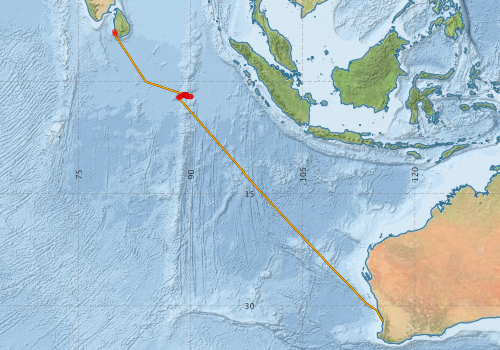
Voyage extents: 32° 02.7' S to 6° 40.1' N 79° 49.4' E to 115° 42.0' E
Marlin Metadata:-
Participants - on ship:-
| Name | Role | Organisation |
|---|---|---|
| Dave Edwards | CSIRO Division of Oceanography | |
| E Bradley | CSIRO Centre for Environmental Mechanics | |
| E. Tanner | Australian Oceanographic Data Centre | |
| Eric Schulz | Flinders University | |
| Ian Helmond | CSIRO Division of Oceanography | |
| J Godfrey | Chief Investigator | CSIRO Division of Oceanography |
| Jeff Butt | CSIRO Division of Oceanography | |
| Lindsay Pender | CSIRO Division of Oceanography | |
| M von Bibra | University of Melbourne | |
| Val Latham | CSIRO Division of Oceanography |
This list includes those that may have only been on part of the voyage. See voyage reports on 'Reports and Maps' tab for details.
Marine National Facility Reports - plans, summaries and data processing
-
FR199409 Voyage Summary
- includes preliminary results, voyage narrative, types of data collected with C77/ROSCOP codes.
-
FR199409 Voyage Plan
- includes objectives, investigator details, proposed data collection, voyage track and equipment to be used.
-

Search for publications, reports and datasets from this and other voyages
Data publishing
This is a list of online datasets hosted by CSIRO. Other processed datasets hosted by collaborating organisations may be found on the 'Metadata' or "Reports, Publications and Maps' tab.
Use the Get data link on the right to extract data using the NCMI Data Trawler.
| Data Stream | Data Summary | Get data | ||||||||||||||
|---|---|---|---|---|---|---|---|---|---|---|---|---|---|---|---|---|
| ADCP Data |
|
Get Data from Trawler Download ASCII dataset - fr9409adcp.zip Download NetCDF dataset - fr9409adcpCDF.zip Processing Report - fr9409adcp.pdf |
||||||||||||||
| CTD profile |
|
Get Data from Trawler |
||||||||||||||
| Hydrology |
|
Get Data from Trawler |
||||||||||||||
| Towed CTD |
|
Get Data from Trawler Download FR199409 Seasoar data |
||||||||||||||
| Underway |
|
Get Data from Trawler |
Deployments by start time:- Click on column header to sort. Use link on 'Deployment' to see full details. Use the CSV button at the bottom to export data (tab delimited).
Search for deployments from this voyage and others
| Deployment | Operation | Station | Cast | Gear | Project | Start and end times | Start Location | End Location | Depth range | Max Depth | Description | |||
|---|---|---|---|---|---|---|---|---|---|---|---|---|---|---|
| Underway System [details] | Anemometer,Anemometer,Anemometer,Barometer,Gyro-MK 10,Humidity probe,Licor-UWQ 4653,RIMCO vane driving potentiometer,RIMCO vane driving potentiometer,Ships log,Simrad EA500 Echosounder,Temperature sensor-AD590J,ThermoSalinoGraph (TSG),ThermoSalinoGraph (TSG) | 1533 | 1994-09-16 00:00 | 1994-10-09 23:55 | 6.6735 | 79.8180 | -32.0493 | 115.7050 | ||||||
| ADCP Data [details] | RDI VM-150 Acoustic Doppler current profiler | 1533 | 1994-09-16 15:00 | 1994-10-08 10:40 | 6.3560 | 79.9020 | -30.5180 | 114.7520 | 408.8 | |||||
| CTD Cast / Hydrology [details] | 1 | Cast 1 | 1533 | 1994-09-20 00:06 | 1994-09-20 00:50 | -1.9993 | 89.9985 | -1.9957 | 89.9998 | 0 | ||||
| CTD Cast / Hydrology [details] | 1 | Cast 2 | 1533 | 1994-09-20 06:36 | 1994-09-20 06:54 | -2.0110 | 89.8468 | -2.0082 | 89.8423 | 0 | ||||
| CTD Cast / Hydrology [details] | 1 | Cast 3 | 1533 | 1994-09-20 08:09 | 1994-09-20 08:35 | -1.9987 | 89.9647 | -1.9948 | 89.9595 | 0 | ||||
| CTD Cast / Hydrology [details] | 1 | Cast 4 | 1533 | 1994-09-20 09:18 | 1994-09-20 09:36 | -1.9992 | 90.0313 | -1.9975 | 90.0278 | 0 | ||||
| Towed CTD [details] | SeaSoar | 1553 | 1994-09-20 09:45 | 1994-09-20 11:03 | 43.5 | Leg: fr0994001 | ||||||||
| Towed CTD [details] | SeaSoar | 1553 | 1994-09-20 11:49 | 1994-09-20 12:14 | 51.8 | Leg: fr0994002 | ||||||||
| Towed CTD [details] | SeaSoar | 1553 | 1994-09-20 12:14 | 1994-09-20 14:27 | 105.3 | Leg: fr0994003 | ||||||||
| Towed CTD [details] | SeaSoar | 1553 | 1994-09-20 14:27 | 1994-09-20 17:12 | 104.5 | Leg: fr0994004 | ||||||||
| Towed CTD [details] | SeaSoar | 1553 | 1994-09-20 17:12 | 1994-09-20 19:12 | 103.8 | Leg: fr0994005 | ||||||||
| Towed CTD [details] | SeaSoar | 1553 | 1994-09-20 19:13 | 1994-09-20 22:14 | 104.2 | Leg: fr0994006 | ||||||||
| Towed CTD [details] | SeaSoar | 1553 | 1994-09-20 22:14 | 1994-09-21 00:10 | 102.3 | Leg: fr0994007 | ||||||||
| Towed CTD [details] | SeaSoar | 1553 | 1994-09-21 00:10 | 1994-09-21 21:40 | 103.4 | Leg: fr0994008 | ||||||||
| Towed CTD [details] | SeaSoar | 1553 | 1994-09-21 03:02 | 1994-09-21 05:12 | 104.4 | Leg: fr0994009 | ||||||||
| Towed CTD [details] | SeaSoar | 1553 | 1994-09-21 06:28 | 1994-09-21 06:29 | 0.3 | Leg: fr0994010 | ||||||||
| CTD Cast / Hydrology [details] | 1 | Cast 5 | 1533 | 1994-09-21 13:00 | 1994-09-21 13:28 | -1.9740 | 89.5777 | -1.9673 | 89.5715 | 0 | ||||
| CTD Cast / Hydrology [details] | 1 | Cast 6 | 1533 | 1994-09-21 14:59 | 1994-09-21 15:26 | -1.9652 | 89.5842 | -1.9570 | 89.5807 | 0 | ||||
| CTD Cast / Hydrology [details] | 1 | Cast 7 | 1533 | 1994-09-21 16:58 | 1994-09-21 17:27 | -1.9565 | 89.5685 | -1.9505 | 89.5648 | 0 | ||||
| CTD Cast / Hydrology [details] | 1 | Cast 8 | 1533 | 1994-09-21 18:59 | 1994-09-21 19:27 | -1.9493 | 89.5592 | -1.9400 | 89.5547 | 0 | ||||
| CTD Cast / Hydrology [details] | 1 | Cast 9 | 1533 | 1994-09-21 21:02 | 1994-09-21 21:26 | -1.9337 | 89.5465 | -1.9248 | 89.5423 | 0 | ||||
| CTD Cast / Hydrology [details] | 1 | Cast 10 | 1533 | 1994-09-21 22:58 | 1994-09-21 23:22 | -1.9147 | 89.5315 | -1.9082 | 89.5237 | 0 | ||||
| CTD Cast / Hydrology [details] | 1 | Cast 11 | 1533 | 1994-09-22 00:43 | 1994-09-22 01:08 | -1.9015 | 89.5207 | -1.8948 | 89.5138 | 0 | ||||
| Towed CTD [details] | SeaSoar | 1553 | 1994-09-22 04:08 | 1994-09-22 04:10 | 44.3 | Leg: fr0994011 | ||||||||
| CTD Cast / Hydrology [details] | 1 | Cast 12 | 1533 | 1994-09-22 06:22 | 1994-09-22 06:45 | -1.8765 | 89.4825 | -1.8700 | 89.4788 | 0 | ||||
| CTD Cast / Hydrology [details] | 1 | Cast 14 | 1533 | 1994-09-22 09:43 | 1994-09-22 10:08 | -1.8583 | 89.4722 | -1.8482 | 89.4692 | 0 | ||||
| CTD Cast / Hydrology [details] | 1 | Cast 15 | 1533 | 1994-09-22 11:01 | 1994-09-22 11:26 | -1.8482 | 89.4670 | -1.8403 | 89.4622 | 0 | ||||
| Towed CTD [details] | SeaSoar | 1553 | 1994-09-22 11:29 | 1994-09-22 13:05 | 118.5 | Leg: fr0994012 | ||||||||
| Towed CTD [details] | SeaSoar | 1553 | 1994-09-22 13:06 | 1994-09-22 19:30 | 152.2 | Leg: fr0994013 | ||||||||
| CTD Cast / Hydrology [details] | 1 | Cast 16 | 1533 | 1994-09-22 21:58 | 1994-09-22 22:24 | -1.7738 | 89.3970 | -1.7673 | 89.3908 | 0 | ||||
| CTD Cast / Hydrology [details] | 1 | Cast 17 | 1533 | 1994-09-22 23:59 | 1994-09-23 00:47 | -1.7660 | 89.3798 | -1.7585 | 89.3657 | 0 | ||||
| CTD Cast / Hydrology [details] | 1 | Cast 18 | 1533 | 1994-09-23 02:00 | 1994-09-23 02:23 | -1.7613 | 89.3603 | -1.7577 | 89.3537 | 0 | ||||
| CTD Cast / Hydrology [details] | 1 | Cast 19 | 1533 | 1994-09-23 05:02 | 1994-09-23 05:24 | -1.7520 | 89.3370 | -1.7477 | 89.3327 | 0 | ||||
| CTD Cast / Hydrology [details] | 1 | Cast 20 | 1533 | 1994-09-23 08:21 | 1994-09-23 08:46 | -1.7453 | 89.3263 | -1.7382 | 89.3222 | 0 | ||||
| CTD Cast / Hydrology [details] | 1 | Cast 21 | 1533 | 1994-09-23 10:19 | 1994-09-23 10:45 | -1.7465 | 89.3223 | -1.7388 | 89.3190 | 0 | ||||
| Towed CTD [details] | SeaSoar | 1553 | 1994-09-23 11:05 | 1994-09-23 11:15 | 0.3 | Leg: fr0994014 | ||||||||
| CTD Cast / Hydrology [details] | 1 | Cast 22 | 1533 | 1994-09-23 13:00 | 1994-09-23 13:25 | -1.7437 | 89.3012 | -1.7402 | 89.2932 | 0 | ||||
| CTD Cast / Hydrology [details] | 1 | Cast 23 | 1533 | 1994-09-23 14:46 | 1994-09-23 15:11 | -1.7405 | 89.2862 | -1.7370 | 89.2837 | 0 | ||||
| CTD Cast / Hydrology [details] | 1 | Cast 24 | 1533 | 1994-09-23 16:53 | 1994-09-23 17:20 | -1.7428 | 89.2677 | -1.7380 | 89.2650 | 0 | ||||
| CTD Cast / Hydrology [details] | 1 | Cast 25 | 1533 | 1994-09-23 19:08 | 1994-09-23 19:29 | -1.7375 | 89.2388 | -1.7337 | 89.2328 | 0 | ||||
| CTD Cast / Hydrology [details] | 1 | Cast 26 | 1533 | 1994-09-23 20:59 | 1994-09-23 21:22 | -1.7328 | 89.2193 | -1.7285 | 89.2135 | 0 | ||||
| CTD Cast / Hydrology [details] | 1 | Cast 27 | 1533 | 1994-09-23 23:01 | 1994-09-23 23:25 | -1.7372 | 89.1922 | -1.7350 | 89.1867 | 0 | ||||
| CTD Cast / Hydrology [details] | 1 | Cast 28 | 1533 | 1994-09-24 00:59 | 1994-09-24 01:20 | -1.7445 | 89.1773 | -1.7425 | 89.1740 | 0 | ||||
| CTD Cast / Hydrology [details] | 1 | Cast 29 | 1533 | 1994-09-24 02:54 | 1994-09-24 03:15 | -1.7570 | 89.1645 | -1.7540 | 89.1597 | 0 | ||||
| CTD Cast / Hydrology [details] | 1 | Cast 30 | 1533 | 1994-09-24 05:29 | 1994-09-24 05:52 | -1.7605 | 89.1362 | -1.7568 | 89.1300 | 0 | ||||
| Towed CTD [details] | SeaSoar | 1553 | 1994-09-24 05:29 | 1994-09-24 08:02 | 169.5 | Leg: fr0994015 | ||||||||
| Towed CTD [details] | SeaSoar | 1553 | 1994-09-24 08:09 | 1994-09-24 08:41 | 92.1 | Leg: fr0994016 | ||||||||
| Towed CTD [details] | SeaSoar | 1553 | 1994-09-24 08:41 | 1994-09-24 09:11 | 92 | Leg: fr0994017 | ||||||||
| Towed CTD [details] | SeaSoar | 1553 | 1994-09-24 09:13 | 1994-09-24 09:19 | 91.4 | Leg: fr0994018 | ||||||||
| Towed CTD [details] | SeaSoar | 1553 | 1994-09-24 09:21 | 1994-09-24 14:11 | 93.4 | Leg: fr0994019 | ||||||||
| Towed CTD [details] | SeaSoar | 1553 | 1994-09-24 14:11 | 1994-09-24 21:51 | 143.6 | Leg: fr0994020 | ||||||||
| Towed CTD [details] | SeaSoar | 1553 | 1994-09-24 21:51 | 1994-09-25 01:50 | 141.4 | Leg: fr0994021 | ||||||||
| Towed CTD [details] | SeaSoar | 1553 | 1994-09-25 02:14 | 1994-09-25 02:18 | 0.2 | Leg: fr0994022 | ||||||||
| Towed CTD [details] | SeaSoar | 1553 | 1994-09-25 05:25 | 1994-09-25 13:30 | 143.5 | Leg: fr0994023 | ||||||||
| CTD Cast / Hydrology [details] | 1 | Cast 31 | 1533 | 1994-09-25 05:36 | 1994-09-25 05:59 | -1.8305 | 88.9447 | -1.8278 | 88.9400 | 0 | ||||
| Towed CTD [details] | SeaSoar | 1553 | 1994-09-25 13:30 | 1994-09-25 20:36 | 144 | Leg: fr0994024 | ||||||||
| Towed CTD [details] | SeaSoar | 1553 | 1994-09-25 20:37 | 1994-09-26 00:11 | 145.3 | Leg: fr0994025 | ||||||||
| Towed CTD [details] | SeaSoar | 1553 | 1994-09-26 00:11 | 1994-09-26 05:20 | 148.1 | Leg: fr0994026 | ||||||||
| Towed CTD [details] | SeaSoar | 1553 | 1994-09-26 06:54 | 1994-09-26 06:58 | 0.3 | Leg: fr0994027 | ||||||||
| Towed CTD [details] | SeaSoar | 1553 | 1994-09-26 07:51 | 1994-09-26 09:23 | 161.4 | Leg: fr0994028 | ||||||||
| CTD Cast / Hydrology [details] | 1 | Cast 32 | 1533 | 1994-09-26 07:58 | 1994-09-26 08:25 | -1.9405 | 88.7550 | -1.9343 | 88.7483 | 0 | ||||
| Towed CTD [details] | SeaSoar | 1553 | 1994-09-27 02:24 | 1994-09-27 02:59 | 141.9 | Leg: fr0994030 | ||||||||
| Towed CTD [details] | SeaSoar | 1553 | 1994-09-27 03:00 | 1994-09-27 06:51 | 139.9 | Leg: fr0994031 | ||||||||
| Towed CTD [details] | SeaSoar | 1553 | 1994-09-27 07:29 | 1994-09-27 07:36 | 115.8 | Leg: fr0994032 | ||||||||
| CTD Cast / Hydrology [details] | 1 | Cast 33 | 1533 | 1994-09-27 08:17 | 1994-09-27 08:45 | -2.0118 | 88.5837 | -2.0058 | 88.5775 | 0 | ||||
| Towed CTD [details] | SeaSoar | 1553 | 1994-09-27 08:35 | 1994-09-27 12:36 | 141.3 | Leg: fr0994033 | ||||||||
| Towed CTD [details] | SeaSoar | 1553 | 1994-09-27 12:36 | 1994-09-27 15:09 | 92.5 | Leg: fr0994034 | ||||||||
| Towed CTD [details] | SeaSoar | 1553 | 1994-09-27 17:36 | 1994-09-27 20:15 | 144.1 | Leg: fr0994035 | ||||||||
| Towed CTD [details] | SeaSoar | 1553 | 1994-09-27 20:15 | 1994-09-28 00:14 | 140 | Leg: fr0994036 | ||||||||
| Towed CTD [details] | SeaSoar | 1553 | 1994-09-28 00:45 | 1994-09-28 00:55 | 0.1 | Leg: fr0994037 | ||||||||
| Towed CTD [details] | SeaSoar | 1553 | 1994-09-28 03:34 | 1994-09-28 07:34 | 125.8 | Leg: fr0994038 | ||||||||
| CTD Cast / Hydrology [details] | 1 | Cast 34 | 1533 | 1994-09-28 03:55 | 1994-09-28 04:17 | -2.0483 | 88.4602 | -2.0447 | 88.4562 | 0 | ||||
| Towed CTD [details] | SeaSoar | 1553 | 1994-09-28 07:34 | 1994-09-28 07:58 | 143.2 | Leg: fr0994039 | ||||||||
| Towed CTD [details] | SeaSoar | 1553 | 1994-09-28 11:40 | 1994-09-28 15:41 | 158 | Leg: fr0994040 | ||||||||
| Towed CTD [details] | SeaSoar | 1553 | 1994-09-28 15:42 | 1994-09-28 19:10 | 150.2 | Leg: fr0994041 | ||||||||
| Towed CTD [details] | SeaSoar | 1553 | 1994-09-28 20:02 | 1994-09-28 22:33 | 91.5 | Leg: fr0994042 | ||||||||
| Towed CTD [details] | SeaSoar | 1553 | 1994-09-28 23:08 | 1994-09-28 23:15 | 0.1 | Leg: fr0994043 | ||||||||
| CTD Cast / Hydrology [details] | 1 | Cast 35 | 1533 | 1994-09-29 00:16 | 1994-09-29 00:39 | -2.1677 | 88.3947 | -2.1698 | 88.3927 | 0 | ||||