Voyage details and related metadata, reports, events and data.
FR 01/94
(alternative identifier: FR199401)
- is a Marine National Facility ![]() voyage
voyage
Period: 1994-01-10 00:00 to 1994-01-18 00:00 Local
Duration: 8.00 days
From: Hobart To: Sydney
Region: Tasman Sea
Ship: Franklin [details]
Description: Cruise FR 01/94 was undertaken to determine the position of the subtropical convergence (STC) off the east and south-east coast of Tasmania during the last glacial/interglacial cycle through the study of deep sea cores. Survey methods included gravity cores, grabs, plankton tows, 1 CTD cast and underway instrumentation. Numerous samples of water, sediment, planktonic and benthic organisms were collected for on board and laboratory analyses.
Leader: P. De Deckker (ANU) including other Pis
Project: National Facility External Users: P. De Deckker (ANU) [details]
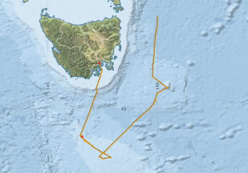
Voyage extents: 47° 17.2' S to 40° 44.2' S 146° 26.2' E to 150° 28.8' E Get voyage track shapefile Get CSV
Marlin Metadata:-
Metadata from OBIS Australia datasets:- biological data is published via the OBIS-AU IPT server and delivered to one or more of OBIS, ALA and GBIF
Download from OBIS Australia IPT View at - Ocean Biodiversity Information System (OBIS) Atlas of Living Australia (ALA) GBIF
Download from OBIS Australia IPT View at - Ocean Biodiversity Information System (OBIS) Atlas of Living Australia (ALA) GBIF
Participants - on ship:-
| Name | Role | Organisation |
|---|---|---|
| Bernadette Heaney | CSIRO Division of Oceanography | |
| Bob Edwards | CSIRO Division of Oceanography | |
| Chikara Hiramatsu | JAPEX, Chiba, Japan | |
| Erik Madsen | CSIRO Division of Oceanography | |
| Jean Jacques Pichon | University of Bordeaux | |
| Leanne Dansie | Australian National University | |
| Mark Rayner | CSIRO Division of Oceanography | |
| Michael Ayress | Australian National University | |
| Patrick De Deckker | Chief Investigator | Australian National University |
| Stefan Nees | Kiel University | |
| Tim Barrows | Australian National University | |
| Tony Rathburn | Australian National University |
This list includes those that may have only been on part of the voyage. See voyage reports on 'Reports and Maps' tab for details.
Marine National Facility Reports - plans, summaries and data processing
-
FR199401 Voyage Summary
- includes preliminary results, voyage narrative, types of data collected with C77/ROSCOP codes.
-
FR199401 Voyage Plan
- includes objectives, investigator details, proposed data collection, voyage track and equipment to be used.
-

Publications, reports and datasets from this voyage.
Dataset
- De Deckker, Patrick; Barrows, Timothy T; Stuut, Jan-Berend W; van der Kaars, Sander; Ayress, M A; Rogers, John; Chaproniere, George C H (2018): Counts of key nanoplankton taxa of sediment core FR1/94-GC3 from the East Tasman Plateau, Australia. PANGAEA, 10.1594/PANGAEA.893211
- De Deckker, Patrick; Barrows, Timothy T; Stuut, Jan-Berend W; van der Kaars, Sander; Ayress, M A; Rogers, John; Chaproniere, George C H (2018): Microfossil counts, sea-surface temperature estimates and quartz grain sizes in the deep-sea core FR1/94-GC3, East Tasman Plateau, Australia. PANGAEA 10.1594/PANGAEA.893214
- De Deckker, Patrick; Barrows, Timothy T; Stuut, Jan-Berend W; van der Kaars, Sander; Ayress, M A; Rogers, John; Chaproniere, George C H (2022): Planktic foraminifera counts from sediment core Fr1/94-GC3. PANGAEA, 10.1594/PANGAEA.946026
- De Deckker, Patrick; van der Kaars, Sander; Macphail, Michael K; Hope, Geoffrey S (2018): Pollen profile of sediment core FR1/94-GC3 from the East Tasman Plateau, Australia. PANGAEA, 10.1594/PANGAEA.893153
IPT Resource
- Planktic foraminifera counts from sediment core Fr1/94-GC3 (Darwin Core Archive) External link to reference
- Seabird observations in Australian and adjacent seas from voyages of the RV Franklin, RV Southern Surveyor, Southern Supporter and RV Aurora Australis (1988-2012) (Darwin Core Archive) External link to reference
Journal Article
- Chikara Hiramatsu and Patrick De Deckker (1997) The late Quaternary calcareous nannoplankton assemblages from three cores from the Tasman Sea. Palaeogeography, Palaeoclimatology, Palaeoecology 131 391-412. 10.1016/S0031-0182(97)00013-8
- De Deckker, P.,Barrows, T. T.,Stuut, J.-B. W.,van der Kaars, S.,Ayress, M. A.,Rogers, J.,Chaproniere, G. (2019) Land–sea correlations in the Australian region: 460 ka of changes recorded in a deep-sea core offshore Tasmania. Part 2: the marine compared with the terrestrial record. Australian Journal of Earth Sciences 66 pp17-36. 10.1080/08120099.2018.1495101
- De Deckker, P.,van der Kaars, S.,Macphail, M. K.,Hope, G. S. (2019) Land-sea correlations in the Australian region: 460 ka of changes recorded in a deep-sea core offshore Tasmania. Part 1: the pollen record. Australian Journal of Earth Sciences 66 pp1-15. 10.1080/08120099.2018.1495100
- Hiramatsu, C,De Deckker, P (1996) Distribution of calcareous nannoplankton near the Subtropical Convergence, south of Tasmania, Australia. Marine and Freshwater Research 47 pp707-. 10.1071/mf9960707
- Pelejero, C.,Calvo, E.,Barrows, T.T.,Logan, G.A.,De Deckker, P. (2006) South Tasman Sea alkenone palaeothermometry over the last four glacial/interglacial cycles. Marine Geology 230 pp73-86. 10.1016/j.margeo.2006.04.004
Search for publications, reports and datasets from this and other voyages
Data publishing
This is a list of online datasets hosted by CSIRO. Other processed datasets hosted by collaborating organisations may be found on the 'Metadata' or "Reports, Publications and Maps' tab.
Use the Get data link on the right to extract data using the NCMI Data Trawler.
| Data Stream | Data Summary | Get data | ||||||||||||
|---|---|---|---|---|---|---|---|---|---|---|---|---|---|---|
| Marine biodiversity observations and/or samples |
|
Get Data from Trawler |
||||||||||||
| CTD profile |
|
Get Data from Trawler |
||||||||||||
| Hydrology |
|
Get Data from Trawler |
||||||||||||
| Underway |
|
Get Data from Trawler |
Deployments by start time:- Click on column header to sort. Use link on 'Deployment' to see full details. Use the CSV button at the bottom to export data (tab delimited).
Search for deployments from this voyage and others
| Deployment | Operation | Station | Cast | Gear | Project | Start and end times | Start Location | End Location | Depth range | Max Depth | Description | |||
|---|---|---|---|---|---|---|---|---|---|---|---|---|---|---|
| Underway System [details] | Anemometer,Anemometer,Anemometer,Barometer,Gyro-MK 10,Humidity probe,Licor-UWQ 4653,RIMCO vane driving potentiometer,RIMCO vane driving potentiometer,Ships log,Simrad EA500 Echosounder,Temperature sensor-AD590J,ThermoSalinoGraph (TSG),ThermoSalinoGraph (TSG) | 125 | 1994-01-10 10:00 | 1994-01-16 23:55 | -42.8863 | 147.3380 | -40.7362 | 149.9900 | ||||||
| CTD Cast / Hydrology [details] | 1 | Cast 1 | 125 | 1994-01-11 15:45 | 1994-01-11 17:14 | -46.2723 | 146.5652 | -46.2898 | 146.5715 | 0 | ||||