Voyage details and related metadata, reports, events and data.
FR 10/93
(alternative identifier: FR199310)
- is a Marine National Facility ![]() voyage
voyage
Period: 1993-12-18 00:00 to 1993-12-22 00:00 Local
Duration: 4.00 days
From: Sydney To: Hobart
Region: NSW coast (Sydney-Hobart)
Ship: Franklin [details]
Description: Cruise FR 10/93 was undertaken to conduct Bunyip and SeaSoar trials to test the modifications under various tow conditions to determine their suitability. Other cruise objectives included to collect oceanographic data from within 5 km of two ground tracks of the TOPEX-POSEIDON satellite for comparison and validation of the satellite's altimeter. Survey methods included ADCP, CTDs, XCTDs and XBTs. Six Bunyip deployments were made during the transit between Sydney and Hobart. Water samples were collected for laboratory analyses.
Leader: L. Pender (CSIRO), including other PI's
Project: Ocean Remote Sensing Project 1981-1997 [details]
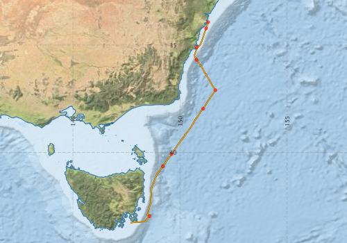
Voyage extents: 43° 17.9' S to 33° 55.6' S 147° 41.8' E to 151° 39.1' E Get voyage track shapefile Get CSV
Marlin Metadata:-
Participants - on ship:-
| Name | Role | Organisation |
|---|---|---|
| C Page | CSIRO Division of Oceanography | |
| Dave Vaudrey | CSIRO Division of Oceanography | |
| Ian Helmond | CSIRO Division of Oceanography | |
| Ian Knott | Antarctic Cooperative Research Centre | |
| Jonathon Reeve | Australian Antarctic Division | |
| L Carter | CSIRO Division of Oceanography | |
| Lindsay Pender | Chief Investigator | CSIRO Division of Oceanography |
| Phil Adams | CSIRO Division of Oceanography | |
| Ron Plaschke | CSIRO Division of Oceanography | |
| Trevor McDougall | CSIRO Division of Oceanography |
This list includes those that may have only been on part of the voyage. See voyage reports on 'Reports and Maps' tab for details.
Marine National Facility Reports - plans, summaries and data processing
-
FR199310 Voyage Summary
- includes preliminary results, voyage narrative, types of data collected with C77/ROSCOP codes.
-

Search for publications, reports and datasets from this and other voyages
Data publishing
This is a list of online datasets hosted by CSIRO. Other processed datasets hosted by collaborating organisations may be found on the 'Metadata' or "Reports, Publications and Maps' tab.
Use the Get data link on the right to extract data using the NCMI Data Trawler.
| Data Stream | Data Summary | Get data | ||||||||||||||
|---|---|---|---|---|---|---|---|---|---|---|---|---|---|---|---|---|
| ADCP Data |
|
Get Data from Trawler Download ASCII dataset - fr9310adcp.zip Download NetCDF dataset - fr9310adcpCDF.zip |
||||||||||||||
| CTD profile |
|
Get Data from Trawler |
||||||||||||||
| Hydrology |
|
Get Data from Trawler |
||||||||||||||
| Underway |
|
Get Data from Trawler |
Deployments by start time:- Click on column header to sort. Use link on 'Deployment' to see full details. Use the CSV button at the bottom to export data (tab delimited).
Search for deployments from this voyage and others
| Deployment | Operation | Station | Cast | Gear | Project | Start and end times | Start Location | End Location | Depth range | Max Depth | Description | |||
|---|---|---|---|---|---|---|---|---|---|---|---|---|---|---|
| Underway System [details] | Anemometer,Anemometer,Anemometer,Barometer,Gyro-MK 10,Humidity probe,Licor-UWQ 4653,RIMCO vane driving potentiometer,RIMCO vane driving potentiometer,Ships log,Simrad EA500 Echosounder,Temperature sensor-AD590J,ThermoSalinoGraph (TSG),ThermoSalinoGraph (TSG) | 1528 | 1993-12-18 07:25 | 1993-12-21 21:55 | -33.9262 | 151.3140 | -43.2988 | 147.6960 | ||||||
| ADCP Data [details] | RDI VM-150 Acoustic Doppler current profiler | 1528 | 1993-12-18 08:40 | 1993-12-21 21:40 | -34.2200 | 151.2180 | -43.2930 | 147.7200 | 344.8 | |||||
| CTD Cast / Hydrology [details] | 1 | Cast 1 | 1528 | 1993-12-18 13:52 | 1993-12-18 14:02 | -35.0995 | 150.7652 | -35.0993 | 150.7642 | 0 | ||||
| CTD Cast / Hydrology [details] | 1 | Cast 2 | 1528 | 1993-12-18 17:51 | 1993-12-18 19:32 | -35.6898 | 150.7705 | -35.6883 | 150.7783 | 0 | ||||
| CTD Cast / Hydrology [details] | 1 | Cast 3 | 1528 | 1993-12-19 03:28 | 1993-12-19 06:27 | -37.1017 | 151.6513 | -37.1077 | 151.6422 | 0 | ||||
| CTD Cast / Hydrology [details] | 1 | Cast 4 | 1528 | 1993-12-19 11:20 | 1993-12-19 14:09 | -37.9652 | 151.0743 | 0 | ||||||
| CTD Cast / Hydrology [details] | 1 | Cast 5 | 1528 | 1993-12-20 05:28 | 1993-12-20 08:05 | -40.0848 | 149.6058 | -40.0735 | 149.6082 | 0 | ||||
| Hydrology Cast [details] | 1 | 1528 | 1993-12-20 13:57 | 1993-12-20 16:09 | -40.6563 | 149.1955 | 2119 | |||||||
| Hydrology Cast [details] | 1 | 1528 | 1993-12-21 11:59 | 1993-12-21 13:42 | -42.9760 | 148.5735 | -42.9850 | 148.5590 | 2506 | |||||