Voyage details and related metadata, reports, events and data.
FR 08/92
(alternative identifier: FR199208)
- is a Marine National Facility ![]() voyage
voyage
Period: 1992-10-07 00:00 to 1992-10-20 00:00 Local
Duration: 13.00 days
From: Brisbane To: Townsville
Region: Cato and Wreck Reefs, Coral Sea
Ship: Franklin [details]
Description: Cruise FR 08/92 was undertaken to examine the physical and biological oceanography around two isolated reefs in the Coral Sea: Cato Reef (23 degrees S, 155 degrees E) and Wreck Reef (22 degrees S, 155 degrees E). Cruise objectives included to determine phytoplankton abundance and productivity about each reef, and to relate these results to the physical measurements and to obtain EZ net and surface samples in the wake of the reefs and in the free stream during both day and night, and to relate the health and abundance of larval fish to the physical environment and primary production. Survey methods included ADCP transects, EZ net tows, CTD profiles, XBTs and underway instrumentation. Data, water and biological samples were collected for on board and laboratory analyses. In addition, one current meter mooring was deployed near Bird Island to the east and one near West Island to the west to monitor flow patterns and will be retrieved during cruise FR 02/93. Related cruise FR 02/93.
Leader: J. Middleton (University of NSW)
Project: National Facility External Users: J. Middleton (University of NSW) [details]
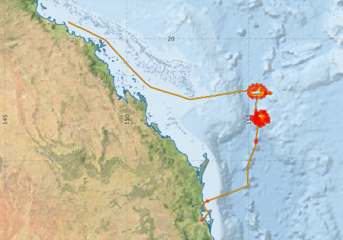
Voyage extents: 27° 26.9' S to 19° 18.7' S 147° 35.9' E to 155° 58.8' E Get voyage track shapefile Get CSV
Marlin Metadata:-
Participants - on ship:-
| Name | Role | Organisation |
|---|---|---|
| Anthony Macks | University of New South Wales - Centre for Marine Science | |
| Dave Edwards | CSIRO Division of Oceanography | |
| Gregory Nippard | University of New South Wales - Centre for Marine Science | |
| Iain Suthers | University of New South Wales - Centre for Marine Science | |
| Jason Middleton | Chief Investigator | University of New South Wales - Centre for Marine Science |
| Jeff Dunn | Cruise Manager | CSIRO Division of Oceanography |
| Mike Lowry | University of New South Wales - Centre for Marine Science | |
| Richard Manasseh | University of New South Wales - Centre for Marine Science | |
| Rick Royle | Monash University | |
| Tom Trnski | Australian Museum |
This list includes those that may have only been on part of the voyage. See voyage reports on 'Reports and Maps' tab for details.
Marine National Facility Reports - plans, summaries and data processing
-
FR199208 Voyage Summary
- includes preliminary results, voyage narrative, types of data collected with C77/ROSCOP codes.
-

Search for publications, reports and datasets from this and other voyages
Data publishing
This is a list of online datasets hosted by CSIRO. Other processed datasets hosted by collaborating organisations may be found on the 'Metadata' or "Reports, Publications and Maps' tab.
Use the Get data link on the right to extract data using the NCMI Data Trawler.
| Data Stream | Data Summary | Get data | ||||||||||||||
|---|---|---|---|---|---|---|---|---|---|---|---|---|---|---|---|---|
| ADCP Data |
|
Get Data from Trawler Download ASCII dataset - fr9208adcp.zip Download NetCDF dataset - fr9208adcpCDF.zip |
||||||||||||||
| CTD profile |
|
Get Data from Trawler |
||||||||||||||
| Hydrology |
|
Get Data from Trawler |
||||||||||||||
| Underway |
|
Get Data from Trawler |
||||||||||||||
| XBT Profile |
Deployments by start time:- Click on column header to sort. Use link on 'Deployment' to see full details. Use the CSV button at the bottom to export data (tab delimited).
Search for deployments from this voyage and others
| Deployment | Operation | Station | Cast | Gear | Project | Start and end times | Start Location | End Location | Depth range | Max Depth | Description | |||
|---|---|---|---|---|---|---|---|---|---|---|---|---|---|---|
| Underway System [details] | Anemometer,Anemometer,Anemometer,Gyro-MK 10,Humidity probe,RIMCO vane driving potentiometer,RIMCO vane driving potentiometer,Ships log,Simrad EA500 Echosounder,Temperature sensor-AD590J,ThermoSalinoGraph (TSG),ThermoSalinoGraph (TSG) | 120 | 1992-10-07 00:00 | 1992-10-19 23:55 | -27.4422 | 153.0720 | -19.3112 | 147.5980 | ||||||
| ADCP Data [details] | RDI VM-150 Acoustic Doppler current profiler | 120 | 1992-10-07 09:40 | 1992-10-19 18:00 | -26.6670 | 153.3040 | -19.4510 | 147.8510 | 368.8 | |||||
| CTD Cast / Hydrology [details] | 1 | Cast 1 | 120 | 1992-10-08 04:45 | 1992-10-08 05:17 | -24.2623 | 155.2993 | -24.2620 | 155.3018 | 0 | ||||
| CTD Cast / Hydrology [details] | 1 | Cast 2 | 120 | 1992-10-08 06:31 | 1992-10-08 07:07 | -24.1733 | 155.3002 | -24.1753 | 155.3012 | 0 | ||||
| CTD Cast / Hydrology [details] | 1 | Cast 3 | 120 | 1992-10-08 22:20 | 1992-10-08 22:48 | -23.2893 | 155.4157 | -23.2840 | 155.4080 | 0 | ||||
| CTD Cast / Hydrology [details] | 1 | Cast 4 | 120 | 1992-10-09 07:08 | 1992-10-09 07:38 | -23.1847 | 155.2645 | -23.1917 | 155.2580 | 0 | ||||
| CTD Cast / Hydrology [details] | 1 | Cast 5 | 120 | 1992-10-09 08:41 | 1992-10-09 09:14 | -23.2320 | 155.3277 | -23.2300 | 155.3233 | 0 | ||||
| CTD Cast / Hydrology [details] | 1 | Cast 6 | 120 | 1992-10-09 10:05 | 1992-10-09 10:39 | -23.2840 | 155.4065 | -23.2785 | 155.4098 | 0 | ||||
| CTD Cast / Hydrology [details] | 1 | Cast 7 | 120 | 1992-10-09 11:28 | 1992-10-09 12:02 | -23.3453 | 155.4837 | -23.3438 | 155.4937 | 0 | ||||
| CTD Cast / Hydrology [details] | 1 | Cast 8 | 120 | 1992-10-09 12:47 | 1992-10-09 13:21 | -23.4158 | 155.5488 | -23.4177 | 155.5478 | 0 | ||||
| CTD Cast / Hydrology [details] | 1 | Cast 9 | 120 | 1992-10-09 14:16 | 1992-10-09 14:50 | -23.5308 | 155.5693 | -23.5363 | 155.5525 | 0 | ||||
| CTD Cast / Hydrology [details] | 1 | Cast 10 | 120 | 1992-10-09 15:39 | 1992-10-09 16:14 | -23.4703 | 155.4915 | -23.4762 | 155.4777 | 0 | ||||
| CTD Cast / Hydrology [details] | 1 | Cast 11 | 120 | 1992-10-09 17:12 | 1992-10-09 17:45 | -23.4177 | 155.4175 | -23.4227 | 155.4132 | 0 | ||||
| CTD Cast / Hydrology [details] | 1 | Cast 12 | 120 | 1992-10-09 18:40 | 1992-10-09 19:12 | -23.3795 | 155.3498 | -23.3788 | 155.3548 | 0 | ||||
| CTD Cast / Hydrology [details] | 1 | Cast 13 | 120 | 1992-10-09 20:12 | 1992-10-09 20:46 | -23.3097 | 155.2713 | -23.3173 | 155.2740 | 0 | ||||
| CTD Cast / Hydrology [details] | 1 | Cast 14 | 120 | 1992-10-09 21:40 | 1992-10-09 22:12 | -23.2573 | 155.2038 | -23.2663 | 155.2003 | 0 | ||||
| CTD Cast / Hydrology [details] | 1 | Cast 15 | 120 | 1992-10-10 01:20 | 1992-10-10 01:51 | -23.2088 | 155.1257 | -23.2153 | 155.1302 | 0 | ||||
| CTD Cast / Hydrology [details] | 1 | Cast 16 | 120 | 1992-10-10 03:00 | 1992-10-10 03:31 | -23.3845 | 155.2003 | -23.3878 | 155.1953 | 0 | ||||
| CTD Cast / Hydrology [details] | 1 | Cast 17 | 120 | 1992-10-10 04:33 | 1992-10-10 05:12 | -23.4417 | 155.2708 | -23.4372 | 155.2725 | 0 | ||||
| CTD Cast / Hydrology [details] | 1 | Cast 18 | 120 | 1992-10-10 06:11 | 1992-10-10 06:43 | -23.4903 | 155.3338 | -23.4857 | 155.3348 | 0 | ||||
| CTD Cast / Hydrology [details] | 1 | Cast 19 | 120 | 1992-10-10 07:36 | 1992-10-10 08:08 | -23.5507 | 155.4145 | -23.5610 | 155.4017 | 0 | ||||
| CTD Cast / Hydrology [details] | 1 | Cast 20 | 120 | 1992-10-10 09:00 | 1992-10-10 09:33 | -23.5983 | 155.4842 | -23.6048 | 155.4713 | 0 | ||||
| CTD Cast / Hydrology [details] | 1 | Cast 21 | 120 | 1992-10-10 12:40 | 1992-10-10 13:12 | -23.3698 | 155.6732 | -23.3723 | 155.6568 | 0 | ||||
| CTD Cast / Hydrology [details] | 1 | Cast 22 | 120 | 1992-10-10 14:40 | 1992-10-10 15:11 | -23.2362 | 155.7147 | -23.2423 | 155.7030 | 0 | ||||
| CTD Cast / Hydrology [details] | 1 | Cast 23 | 120 | 1992-10-10 16:08 | 1992-10-10 16:41 | -23.1168 | 155.6818 | -23.1170 | 155.6672 | 0 | ||||
| CTD Cast / Hydrology [details] | 1 | Cast 24 | 120 | 1992-10-10 17:27 | 1992-10-10 17:57 | -23.0657 | 155.5478 | -23.0687 | 155.5420 | 0 | ||||
| CTD Cast / Hydrology [details] | 1 | Cast 25 | 120 | 1992-10-10 18:56 | 1992-10-10 19:29 | -23.0992 | 155.4007 | -23.1045 | 155.4022 | 0 | ||||
| CTD Cast / Hydrology [details] | 1 | Cast 26 | 120 | 1992-10-10 20:15 | 1992-10-10 20:48 | -23.1408 | 155.3343 | -23.1433 | 155.3378 | 0 | ||||
| CTD Cast / Hydrology [details] | 1 | Cast 27 | 120 | 1992-10-10 21:45 | 1992-10-10 22:03 | -23.2843 | 155.4038 | -23.2832 | 155.4087 | 0 | ||||
| CTD Cast / Hydrology [details] | 1 | Cast 28 | 120 | 1992-10-11 08:58 | 1992-10-11 09:30 | -23.3157 | 155.1197 | -23.3165 | 155.1202 | 0 | ||||
| CTD Cast / Hydrology [details] | 1 | Cast 29 | 120 | 1992-10-11 20:31 | 1992-10-11 21:01 | -23.2847 | 155.6140 | -23.2875 | 155.6113 | 0 | ||||
| CTD Cast / Hydrology [details] | 1 | Cast 30 | 120 | 1992-10-11 21:52 | 1992-10-11 22:13 | -23.3323 | 155.7142 | -23.3273 | 155.7113 | 0 | ||||
| CTD Cast / Hydrology [details] | 1 | Cast 31 | 120 | 1992-10-11 22:41 | 1992-10-11 23:15 | -23.3198 | 155.7035 | -23.3093 | 155.6943 | 0 | ||||
| XBT Cast [details] | 120 | 1992-10-12 08:14 | -22.9888 | 155.6192 | 165 | |||||||||
| XBT Cast [details] | 120 | 1992-10-12 08:27 | -23.0112 | 155.6180 | 760 | |||||||||
| XBT Cast [details] | 120 | 1992-10-12 08:42 | -23.0232 | 155.6338 | 760 | |||||||||
| XBT Cast [details] | 120 | 1992-10-12 11:44 | -23.2823 | 155.8172 | 760 | |||||||||
| XBT Cast [details] | 120 | 1992-10-12 12:54 | -23.4152 | 155.7817 | 760 | |||||||||
| XBT Cast [details] | 120 | 1992-10-12 14:00 | -23.5147 | 155.6177 | 760 | |||||||||
| XBT Cast [details] | 120 | 1992-10-12 14:58 | -23.4980 | 155.4300 | 760 | |||||||||
| XBT Cast [details] | 120 | 1992-10-12 16:18 | -23.3087 | 155.2718 | 760 | |||||||||
| XBT Cast [details] | 120 | 1992-10-12 17:00 | -23.1927 | 155.2700 | 760 | |||||||||
| XBT Cast [details] | 120 | 1992-10-12 18:01 | -23.0553 | 155.3572 | 760 | |||||||||
| XBT Cast [details] | 120 | 1992-10-12 19:00 | -22.9838 | 155.4958 | 760 | |||||||||
| XBT Cast [details] | 120 | 1992-10-12 20:04 | -23.0090 | 155.6550 | 760 | |||||||||
| XBT Cast [details] | 120 | 1992-10-12 21:03 | -23.1292 | 155.7307 | 760 | |||||||||
| XBT Cast [details] | 120 | 1992-10-12 22:01 | -23.2658 | 155.7785 | 760 | |||||||||
| CTD Cast / Hydrology [details] | 1 | Cast 32 | 120 | 1992-10-13 06:49 | 1992-10-13 07:22 | -23.3863 | 155.8100 | -23.3808 | 155.8033 | 0 | ||||
| CTD Cast / Hydrology [details] | 1 | Cast 33 | 120 | 1992-10-13 21:49 | 1992-10-13 22:20 | -23.4428 | 155.2693 | -23.4377 | 155.2582 | 0 | ||||
| XBT Cast [details] | 120 | 1992-10-13 23:08 | -23.3223 | 155.2868 | 760 | |||||||||
| XBT Cast [details] | 120 | 1992-10-13 23:32 | -23.2463 | 155.2910 | 760 | |||||||||
| XBT Cast [details] | 120 | 1992-10-13 23:46 | -23.2012 | 155.2938 | 760 | |||||||||
| XBT Cast [details] | 120 | 1992-10-14 00:18 | -23.0997 | 155.2953 | 760 | |||||||||
| XBT Cast [details] | 120 | 1992-10-14 00:34 | -23.0488 | 155.2938 | 760 | |||||||||
| XBT Cast [details] | 120 | 1992-10-14 01:06 | -22.9493 | 155.2895 | 760 | |||||||||
| CTD Cast / Hydrology [details] | 1 | Cast 34 | 120 | 1992-10-14 04:02 | 1992-10-14 04:35 | -22.4147 | 155.3330 | -22.4063 | 155.3402 | 0 | ||||
| CTD Cast / Hydrology [details] | 1 | Cast 35 | 120 | 1992-10-14 05:42 | 1992-10-14 06:14 | -22.4165 | 155.5017 | -22.4125 | 155.5042 | 0 | ||||
| CTD Cast / Hydrology [details] | 1 | Cast 36 | 120 | 1992-10-14 07:02 | 1992-10-14 07:36 | -22.3682 | 155.6140 | -22.3612 | 155.6167 | 0 | ||||
| CTD Cast / Hydrology [details] | 1 | Cast 37 | 120 | 1992-10-14 08:31 | 1992-10-14 09:04 | -22.2492 | 155.6985 | -22.2397 | 155.6987 | 0 | ||||
| CTD Cast / Hydrology [details] | 1 | Cast 38 | 120 | 1992-10-14 09:55 | 1992-10-14 10:31 | -22.1168 | 155.7013 | -22.1080 | 155.7037 | 0 | ||||
| CTD Cast / Hydrology [details] | 1 | Cast 39 | 120 | 1992-10-14 11:22 | 1992-10-14 11:59 | -22.0003 | 155.6158 | -21.9930 | 155.6162 | 0 | ||||
| CTD Cast / Hydrology [details] | 1 | Cast 40 | 120 | 1992-10-14 12:59 | 1992-10-14 13:32 | -21.9172 | 155.4992 | -21.9160 | 155.4960 | 0 | ||||
| CTD Cast / Hydrology [details] | 1 | Cast 41 | 120 | 1992-10-14 14:36 | 1992-10-14 15:09 | -21.9178 | 155.3348 | -21.9152 | 155.3382 | 0 | ||||
| CTD Cast / Hydrology [details] | 1 | Cast 42 | 120 | 1992-10-14 16:13 | 1992-10-14 16:45 | -21.9175 | 155.1667 | -21.9082 | 155.1703 | 0 | ||||
| CTD Cast / Hydrology [details] | 1 | Cast 43 | 120 | 1992-10-14 17:38 | 1992-10-14 18:09 | -22.0005 | 155.0660 | -21.9937 | 155.0638 | 0 | ||||
| CTD Cast / Hydrology [details] | 1 | Cast 44 | 120 | 1992-10-14 19:03 | 1992-10-14 19:33 | -22.1152 | 155.0018 | -22.1113 | 154.9992 | 0 | ||||
| CTD Cast / Hydrology [details] | 1 | Cast 45 | 120 | 1992-10-14 20:34 | 1992-10-14 21:05 | -22.2477 | 155.0007 | -22.2437 | 154.9972 | 0 | ||||
| CTD Cast / Hydrology [details] | 1 | Cast 46 | 120 | 1992-10-14 22:14 | 1992-10-14 22:45 | -22.3657 | 155.0662 | -22.3548 | 155.0695 | 0 | ||||
| CTD Cast / Hydrology [details] | 1 | Cast 47 | 120 | 1992-10-14 23:35 | 1992-10-15 00:06 | -22.4168 | 155.1658 | -22.4075 | 155.1710 | 0 | ||||
| CTD Cast / Hydrology [details] | 1 | Cast 48 | 120 | 1992-10-15 03:47 | 1992-10-15 04:19 | -22.2417 | 155.6957 | -22.2323 | 155.6907 | 0 | ||||
| CTD Cast / Hydrology [details] | 1 | Cast 49 | 120 | 1992-10-15 06:46 | 1992-10-15 07:20 | -22.2452 | 155.8685 | -22.2433 | 155.8655 | 0 | ||||
| CTD Cast / Hydrology [details] | 1 | Cast 50 | 120 | 1992-10-15 22:33 | 1992-10-15 22:58 | -22.2428 | 155.6993 | -22.2392 | 155.6960 | 0 | ||||
| CTD Cast / Hydrology [details] | 1 | Cast 51 | 120 | 1992-10-16 17:37 | 1992-10-16 18:09 | -22.0002 | 155.3325 | -21.9953 | 155.3215 | 0 | ||||
| CTD Cast / Hydrology [details] | 1 | Cast 52 | 120 | 1992-10-16 21:33 | 1992-10-16 22:00 | -22.1033 | 155.2618 | -22.1095 | 155.2563 | 0 | ||||
| CTD Cast / Hydrology [details] | 1 | Cast 53 | 120 | 1992-10-17 21:44 | 1992-10-17 22:09 | -22.1080 | 155.5292 | -22.1052 | 155.5172 | 0 | ||||
| CTD Cast [details] | 1 | Cast 54 | 120 | 1992-10-18 00:00 | 1992-10-18 00:09 | -22.1127 | 155.1715 | -22.1143 | 155.1697 | 0 | ||||