Voyage details and related metadata, reports, events and data.
FR 02/92
(alternative identifier: FR199202)
- is a Marine National Facility ![]() voyage
voyage
Period: 1992-02-06 00:00 to 1992-02-18 00:00 Local
Duration: 12.00 days
From: Townsville To: Townsville
Region: NE Australian slope, Coral Sea
Ship: Franklin [details]
Description: Cruise FR 02/92 (also know as CIDARIS III) was undertaken to collect samples of deep sea bottom fauna from the NE Australian Slope and the adjacent Coral Sea. Survey methods included grabs, sledges, beam trawls and underway instrumentation. The macrofauna collected by sledge and beam trawl represents an excellent sample of the bathyal and upper abyssal benthic fauna and complements the species list obtained in particular during cruise FR 07/88 (CIDARIS II). On board preliminary sorting indicates that a number of specimens belong to new or little know species. Furthermore, valuable data has been obtained on the changes in faunal assemblage with depth and in particular with the nature of the sediment and the amount or organic matter available at the water-sediment interface, resulting from land-derived inputs.
Leader: M. Pichon (AIMS), P. Arnold (Mus. Trop. QLD) & R. Birtle (James Cook University)
Project: National Facility External Users: M. Pichon (AIMS) [details]
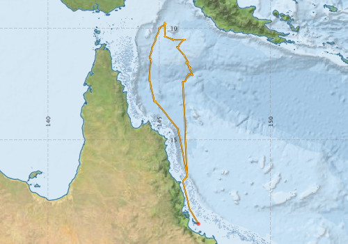
Voyage extents: 18° 46.6' S to 9° 43.9' S 144° 32.4' E to 146° 45.3' E Get voyage track shapefile Get CSV
Marlin Metadata:-
Participants - on ship:-
| Name | Role | Organisation |
|---|---|---|
| A Birtles | James Cook University | |
| A Bruce | Northern Territory Museum | |
| Alan Poole | CSIRO Division of Oceanography | |
| D Garcia | Australian Institute of Marine Science (AIMS) | |
| J Brunskill | Australian Institute of Marine Science (AIMS) | |
| M Pichon | Chief Investigator | Australian Institute of Marine Science (AIMS) |
| Neil White | Cruise Manager | CSIRO Division of Oceanography |
| Otto Dalhaus | Australian Institute of Marine Science (AIMS) | |
| P Christofferson | Australian Institute of Marine Science (AIMS) | |
| P Davie | Queensland Museum | |
| Peter Arnold | Museum of Tropical Queensland |
This list includes those that may have only been on part of the voyage. See voyage reports on 'Reports and Maps' tab for details.
Marine National Facility Reports - plans, summaries and data processing
-
FR199202 Voyage Summary
- includes preliminary results, voyage narrative, types of data collected with C77/ROSCOP codes.
-
FR199202 Voyage Plan
- includes objectives, investigator details, proposed data collection, voyage track and equipment to be used.
-

Search for publications, reports and datasets from this and other voyages
Data publishing
This is a list of online datasets hosted by CSIRO. Other processed datasets hosted by collaborating organisations may be found on the 'Metadata' or "Reports, Publications and Maps' tab.
Use the Get data link on the right to extract data using the NCMI Data Trawler.
| Data Stream | Data Summary | Get data | ||||||||||||
|---|---|---|---|---|---|---|---|---|---|---|---|---|---|---|
| Underway |
|
Get Data from Trawler |
Deployments by start time:- Click on column header to sort. Use link on 'Deployment' to see full details. Use the CSV button at the bottom to export data (tab delimited).
Search for deployments from this voyage and others
| Deployment | Operation | Station | Cast | Gear | Project | Start and end times | Start Location | End Location | Depth range | Max Depth | Description | |||
|---|---|---|---|---|---|---|---|---|---|---|---|---|---|---|
| Underway System [details] | Simrad EA500 Echosounder | 132 | 1992-02-06 00:00 | 1992-02-18 23:55 | -18.7770 | 146.7550 | -16.8413 | 146.0720 | ||||||