Voyage details and related metadata, reports, events and data.
FR 03.2/91
(alternative identifier: FR199103-2)
- is a Marine National Facility ![]() voyage
voyage
Period: 1991-03-27 00:00 to 1991-03-31 00:00 Local
Duration: 4.00 days
From: Hobart To: Hobart
Region: SE Tasmania (jarosite dumpsite)
Ship: Franklin [details]
Description: Cruise FR 32/91 was undertaken to monitor the plume of jarosite waste discharged periodically by Pasminco Metals - EZ, (using the M. V. Anson), at a dump site approximately 60 nautical miles southeast of Hobart, in 2000 m of water in the Tasman Sea (nominally at 43 degrees 36.5' S, 148 degrees 14.5' E). Survey methods included the Seasoar vehicle, equipped with a CTD and transmissometer, XBTs, acoustic sounders and underway instrumentation. Jarosite patch was located and successfully surveyed.
Leader: J. Hunter (CSIRO)
Project: Ocean Remote Sensing Project 1981-1997 [details]
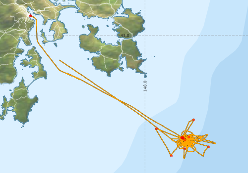
Voyage extents: 43° 43.0' S to 42° 53.2' S 147° 20.3' E to 148° 24.5' E
Marlin Metadata:-
Participants - on ship:-
| Name | Role | Organisation |
|---|---|---|
| Bill Wilson | Pasminco Metals EZ | |
| Bob Griffiths | CSIRO Division of Fisheries | |
| Cecil Scott | CSIRO Division of Oceanography | |
| David Eades | Royal Australasian Ornithologist Union | |
| David Mitchell | Pasminco Metals EZ | |
| Ian Helmond | CSIRO Division of Oceanography | |
| Jan Peterson | Cruise Manager | CSIRO Division of Oceanography |
| John Hunter | Chief Investigator | CSIRO Division of Oceanography |
| Lindsay Pender | CSIRO Division of Oceanography | |
| Phil Adams | CSIRO Division of Oceanography | |
| Stephanie Davenport | CSIRO Division of Fisheries | |
| Stuart Swan | CSIRO Division of Oceanography |
This list includes those that may have only been on part of the voyage. See voyage reports on 'Reports and Maps' tab for details.
Marine National Facility Reports - plans, summaries and data processing

Search for publications, reports and datasets from this and other voyages
Data publishing
This is a list of online datasets hosted by CSIRO. Other processed datasets hosted by collaborating organisations may be found on the 'Metadata' or "Reports, Publications and Maps' tab.
Use the Get data link on the right to extract data using the NCMI Data Trawler.
| Data Stream | Data Summary | Get data | ||||||||||||||
|---|---|---|---|---|---|---|---|---|---|---|---|---|---|---|---|---|
| ADCP Data |
|
Get Data from Trawler Download ASCII dataset fr9132adcp.zip Download NetCDF dataset fr9132adcpCDF.zip |
||||||||||||||
| CTD profile | No data | |||||||||||||||
| Hydrology |
|
Get Data from Trawler |
||||||||||||||
| Underway |
|
Get Data from Trawler Download Underway Data fr199103-2uwy.zip |
Deployments by start time:- Click on column header to sort. Use link on 'Deployment' to see full details. Use the CSV button at the bottom to export data (tab delimited).
Search for deployments from this voyage and others
| Deployment | Operation | Station | Cast | Gear | Project | Start and end times | Start Location | End Location | Depth range | Max Depth | Description | |||
|---|---|---|---|---|---|---|---|---|---|---|---|---|---|---|
| Underway System [details] | Anemometer,Anemometer,Anemometer,Humidity probe,RIMCO vane driving potentiometer,RIMCO vane driving potentiometer,Simrad EA500 Echosounder,Temperature sensor-AD590J,ThermoSalinoGraph (TSG),ThermoSalinoGraph (TSG) | 1528 | 1991-03-27 00:00 | 1991-03-31 00:50 | -42.8862 | 147.3380 | -43.0642 | 147.4040 | ||||||
| ADCP Data [details] | RDI Ocean Surveyor Acoustic Doppler current profiler | 1528 | 1991-03-27 02:00 | 1991-03-31 00:40 | -42.8860 | 147.3380 | -43.0690 | 147.4100 | 420 | |||||
| Hydrology Cast [details] | 1 | 1528 | 1991-03-27 11:32 | 1991-03-27 12:43 | -43.5938 | 148.2215 | -43.6063 | 148.2458 | 1499 | |||||
| Hydrology Cast [details] | 1 | 1528 | 1991-03-27 13:25 | 1991-03-27 14:42 | -43.5985 | 148.2203 | -43.6138 | 148.2410 | 1499 | |||||
| Hydrology Cast [details] | 1 | 1528 | 1991-03-27 15:21 | 1991-03-27 16:25 | -43.5940 | 148.2120 | -43.6000 | 148.2172 | 1498 | |||||
| Hydrology Cast [details] | 1 | 1528 | 1991-03-27 17:01 | 1991-03-27 18:07 | -43.5935 | 148.2140 | -43.5995 | 148.2243 | 1501 | |||||
| Hydrology Cast [details] | 1 | 1528 | 1991-03-27 18:28 | 1991-03-27 19:36 | -43.5963 | 148.2178 | -43.6110 | 148.2263 | 1491 | |||||
| Hydrology Cast [details] | 1 | 1528 | 1991-03-29 08:37 | 1991-03-29 09:06 | -43.6063 | 148.2308 | -43.6088 | 148.2248 | 6 | |||||
| Hydrology Cast [details] | 1 | 1528 | 1991-03-29 10:06 | 1991-03-29 11:21 | -43.6473 | 148.3685 | -43.6723 | 148.3457 | 2729 | |||||
| Hydrology Cast [details] | 1 | 1528 | 1991-03-29 13:35 | 1991-03-29 14:54 | -43.5932 | 148.2193 | -43.5962 | 148.2105 | 1801 | |||||
| Hydrology Cast [details] | 1 | 1528 | 1991-03-29 15:51 | 1991-03-29 16:38 | -43.5417 | 148.0667 | -43.5402 | 148.0575 | 927 | |||||
| Hydrology Cast [details] | 1 | 1528 | 1991-03-29 17:51 | 1991-03-29 18:59 | -43.6987 | 148.1533 | 1831 | |||||||
| Hydrology Cast [details] | 1 | 1528 | 1991-03-29 21:25 | 1991-03-29 22:41 | -43.4905 | 148.2820 | -43.4965 | 148.2662 | 1476 | |||||
| Hydrology Cast [details] | 1 | 1528 | 1991-03-30 03:58 | 1991-03-30 05:04 | -43.6582 | 148.2285 | -43.6617 | 148.2383 | 1499 | |||||
| Hydrology Cast [details] | 1 | 1528 | 1991-03-30 08:39 | 1991-03-30 08:57 | -43.5902 | 148.2537 | -43.5900 | 148.2617 | 251 | |||||