Voyage details and related metadata, reports, events and data.
FR 03/91
(alternative identifier: FR199103)
- is a Marine National Facility ![]() voyage
voyage
Period: 1991-03-06 00:00 to 1991-03-27 00:00 Local
Duration: 21.00 days
From: Hobart To: Hobart
Region: Southern Ocean/Tasman Sea
Ship: Franklin [details]
Description: Cruise FR 03/91 was undertaken to collect the first microstructure measurements from the Southern Ocean in the Antarctic Circumpolar Current and to compare these with the internal wave activity. Survey methods included CTDs, XBTs, XCPs, Bunyip tows, ADCP and underway instrumentation. From the data collected, analysis will be conducted to determine the strength of vertical mixing processes in this region.
Leader: T. McDougall (CSIRO) & M. Gregg (Univ. of Washington)
Project: Climate Change 1989-1997 [details]
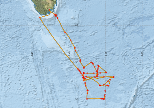
Voyage extents: 55° 02.0' S to 42° 53.2' S 145° 59.8' E to 156° 05.9' E Get voyage track shapefile Get CSV
Marlin Metadata:-
Metadata from OBIS Australia datasets:- biological data is published via the OBIS-AU IPT server and delivered to one or more of OBIS, ALA and GBIF
Download from OBIS Australia IPT View at - Ocean Biodiversity Information System (OBIS) Atlas of Living Australia (ALA) GBIF
Participants - on ship:-
| Name | Role | Organisation |
|---|---|---|
| Bob Griffiths | CSIRO Division of Fisheries | |
| Earl Krause | University of Washington | |
| Ian Helmond | CSIRO Division of Oceanography | |
| John Hunter | CSIRO Division of Oceanography | |
| Leigh Carter | CSIRO Division of Oceanography | |
| Lindsay Pender | CSIRO Division of Oceanography | |
| Mark Hindell | Royal Australasian Ornithologist Union | |
| Nathon Bindoff | CSIRO Division of Oceanography | |
| Paul Boult | CSIRO Division of Oceanography | |
| Phil Adams | CSIRO Division of Oceanography | |
| Stuart Swan | CSIRO Division of Oceanography | |
| Trevor McDougall | Chief Investigator | CSIRO Division of Oceanography |
This list includes those that may have only been on part of the voyage. See voyage reports on 'Reports and Maps' tab for details.
Marine National Facility Reports - plans, summaries and data processing
-
FR199103 Voyage Summary
- includes preliminary results, voyage narrative, types of data collected with C77/ROSCOP codes.
-
FR199103 Voyage Plan
- includes objectives, investigator details, proposed data collection, voyage track and equipment to be used.
-

Publications, reports and datasets from this voyage.
IPT Resource
- Seabird observations in Australian and adjacent seas from voyages of the RV Franklin, RV Southern Surveyor, Southern Supporter and RV Aurora Australis (1988-2012) (Darwin Core Archive) External link to reference
Search for publications, reports and datasets from this and other voyages
Data publishing
This is a list of online datasets hosted by CSIRO. Other processed datasets hosted by collaborating organisations may be found on the 'Metadata' or "Reports, Publications and Maps' tab.
Use the Get data link on the right to extract data using the NCMI Data Trawler.
| Data Stream | Data Summary | Get data | ||||||||||||||
|---|---|---|---|---|---|---|---|---|---|---|---|---|---|---|---|---|
| ADCP Data |
|
Get Data from Trawler Download ASCII dataset fr9103adcp.zip Download NetCDF dataset fr9103adcpCDF.zip |
||||||||||||||
| Marine biodiversity observations and/or samples |
|
Get Data from Trawler |
||||||||||||||
| CTD profile |
|
Get Data from Trawler |
||||||||||||||
| Hydrology |
|
Get Data from Trawler |
||||||||||||||
| Towed CTD |
|
Get Data from Trawler Download FR199103 Seasoar data |
||||||||||||||
| Underway |
|
Get Data from Trawler |
||||||||||||||
| XBT Profile |
Deployments by start time:- Click on column header to sort. Use link on 'Deployment' to see full details. Use the CSV button at the bottom to export data (tab delimited).
Search for deployments from this voyage and others
| Deployment | Operation | Station | Cast | Gear | Project | Start and end times | Start Location | End Location | Depth range | Max Depth | Description | |||
|---|---|---|---|---|---|---|---|---|---|---|---|---|---|---|
| Underway System [details] | Anemometer,Anemometer,Anemometer,Humidity probe,RIMCO vane driving potentiometer,RIMCO vane driving potentiometer,Simrad EA500 Echosounder,Temperature sensor-AD590J,ThermoSalinoGraph (TSG),ThermoSalinoGraph (TSG) | 1533 | 1991-03-05 23:45 | 1991-03-26 23:55 | -42.8855 | 147.3380 | -42.8862 | 147.3380 | ||||||
| ADCP Data [details] | RDI VM-150 Acoustic Doppler current profiler | 1533 | 1991-03-06 08:20 | 1991-03-31 00:40 | -43.9350 | 145.9980 | -43.0690 | 147.4100 | 488.8 | |||||
| CTD Cast / Hydrology [details] | 1 | Cast 1 | 1533 | 1991-03-08 02:59 | 1991-03-08 03:40 | -50.9260 | 151.2077 | -50.9302 | 151.2198 | 0 | ||||
| XBT Cast [details] | 1533 | 1991-03-08 05:23 | -51.0922 | 151.3688 | 295 | |||||||||
| XBT Cast [details] | 1533 | 1991-03-08 06:37 | -51.2293 | 151.4775 | 760 | |||||||||
| XBT Cast [details] | 1533 | 1991-03-08 07:24 | -51.3728 | 151.5710 | 760 | |||||||||
| XBT Cast [details] | 1533 | 1991-03-08 08:19 | -51.5523 | 151.6817 | 760 | |||||||||
| XBT Cast [details] | 1533 | 1991-03-08 09:25 | -51.7782 | 151.8223 | 375 | |||||||||
| CTD Cast / Hydrology [details] | 1 | Cast 2 | 1533 | 1991-03-08 11:16 | 1991-03-08 12:59 | -52.0243 | 151.9975 | -52.0770 | 151.9583 | 0 | ||||
| CTD Cast [details] | 1 | Cast 3 | 1533 | 1991-03-08 13:37 | 1991-03-08 14:12 | -52.1218 | 151.9443 | -52.1457 | 151.9318 | 0 | ||||
| Towed CTD [details] | SeaSoar | 1553 | 1991-03-08 16:50 | 1991-03-08 17:00 | -52.2763 | 152.1632 | 228.3 | Leg: fr0391001.avg4 | ||||||
| CTD Cast / Hydrology [details] | 1 | Cast 4 | 1533 | 1991-03-08 23:31 | 1991-03-09 01:05 | -51.9968 | 151.9997 | -52.0442 | 151.9695 | 0 | ||||
| CTD Cast / Hydrology [details] | 1 | Cast 5 | 1533 | 1991-03-09 02:10 | 1991-03-09 03:38 | -52.0782 | 151.9463 | -52.1173 | 151.9043 | 0 | ||||
| CTD Cast [details] | 1 | Cast 6 | 1533 | 1991-03-09 04:35 | 1991-03-09 05:58 | -52.0820 | 151.9388 | -52.1162 | 151.9017 | 0 | ||||
| CTD Cast / Hydrology [details] | 1 | Cast 7 | 1533 | 1991-03-09 12:22 | 1991-03-09 14:09 | -52.1847 | 151.9752 | -52.2403 | 151.9703 | 0 | ||||
| Towed CTD [details] | SeaSoar | 1553 | 1991-03-09 15:20 | 1991-03-09 16:35 | -52.2217 | 152.1473 | -52.3730 | 152.1678 | 277.5 | Leg: fr0391002.avg4 | ||||
| Towed CTD [details] | SeaSoar | 1553 | 1991-03-09 17:48 | 1991-03-09 20:10 | -52.8410 | 152.2053 | 458.2 | Leg: fr0391003.avg4 | ||||||
| Towed CTD [details] | SeaSoar | 1553 | 1991-03-09 20:13 | 1991-03-09 23:09 | -52.8467 | 152.2055 | -53.2230 | 152.2803 | 569.5 | Leg: fr0391004.avg4 | ||||
| Towed CTD [details] | SeaSoar | 1553 | 1991-03-09 23:11 | 1991-03-10 04:21 | -53.2268 | 152.2815 | -53.7417 | 152.5060 | 727.8 | Leg: fr0391005.avg4 | ||||
| CTD Cast / Hydrology [details] | 1 | Cast 8 | 1533 | 1991-03-10 05:10 | 1991-03-10 06:41 | -53.8550 | 152.5343 | -53.8505 | 152.5287 | 0 | ||||
| CTD Cast / Hydrology [details] | 1 | Cast 9 | 1533 | 1991-03-10 07:18 | 1991-03-10 08:41 | -53.8297 | 152.4997 | -53.8310 | 152.4912 | 0 | ||||
| Towed CTD [details] | SeaSoar | 1553 | 1991-03-10 09:51 | 1991-03-10 12:45 | -53.8715 | 152.5687 | -54.2447 | 152.5258 | 351.2 | Leg: fr0391006.avg4 | ||||
| Towed CTD [details] | SeaSoar | 1553 | 1991-03-10 12:46 | 1991-03-10 18:33 | -54.2455 | 152.5257 | -55.0085 | 152.4578 | 382 | Leg: fr0391007.avg4 | ||||
| Towed CTD [details] | SeaSoar | 1553 | 1991-03-10 18:34 | 1991-03-11 00:56 | -55.0092 | 152.4600 | -54.9767 | 154.0022 | 331.6 | Leg: fr0391008.avg4 | ||||
| XBT Cast [details] | 1533 | 1991-03-11 03:27 | -54.9807 | 154.3848 | 760 | |||||||||
| XBT Cast [details] | 1533 | 1991-03-11 03:49 | -54.9887 | 154.5013 | 525 | |||||||||
| CTD Cast / Hydrology [details] | 1 | Cast 10 | 1533 | 1991-03-11 04:28 | 1991-03-11 06:09 | -54.9998 | 154.6672 | -55.0242 | 154.6680 | 0 | ||||
| CTD Cast / Hydrology [details] | 1 | Cast 11 | 1533 | 1991-03-11 07:15 | 1991-03-11 08:47 | -55.0030 | 154.6640 | -55.0282 | 154.6748 | 0 | ||||
| Towed CTD [details] | SeaSoar | 1553 | 1991-03-11 09:32 | 1991-03-11 12:50 | -55.0300 | 154.7940 | -54.6485 | 154.8788 | 460 | Leg: fr0391012.avg4 | ||||
| Towed CTD [details] | SeaSoar | 1553 | 1991-03-11 12:51 | 1991-03-11 14:31 | -54.6472 | 154.8790 | -54.4393 | 154.9015 | 599.7 | Leg: fr0391013.avg4 | ||||
| Towed CTD [details] | SeaSoar | 1553 | 1991-03-11 14:32 | 1991-03-11 19:03 | -54.4388 | 154.9015 | -53.9118 | 154.9372 | 745.9 | Leg: fr0391014.avg4 | ||||
| Towed CTD [details] | SeaSoar | 1553 | 1991-03-11 19:03 | 1991-03-12 01:49 | -53.9115 | 154.9372 | -53.1080 | 155.0232 | 589.5 | Leg: fr0391016.avg4 | ||||
| CTD Cast / Hydrology [details] | 1 | Cast 12 | 1533 | 1991-03-12 02:36 | 1991-03-12 04:12 | -53.1758 | 155.2167 | -53.1812 | 155.2297 | 0 | ||||
| CTD Cast / Hydrology [details] | 1 | Cast 13 | 1533 | 1991-03-12 04:57 | 1991-03-12 06:13 | -53.1772 | 155.2208 | -53.1890 | 155.2367 | 0 | ||||
| Towed CTD [details] | SeaSoar | 1553 | 1991-03-12 07:57 | 1991-03-12 09:56 | -53.2293 | 155.4117 | -53.0132 | 155.4768 | 339.9 | Leg: fr0391017.avg4 | ||||
| Towed CTD [details] | SeaSoar | 1553 | 1991-03-12 10:14 | 1991-03-12 12:14 | 514.1 | Leg: fr0391021.avg4 | ||||||||
| Towed CTD [details] | SeaSoar | 1553 | 1991-03-12 12:19 | 1991-03-12 16:17 | -52.3742 | 155.6310 | 769.2 | Leg: fr0391022.avg4 | ||||||
| Towed CTD [details] | SeaSoar | 1553 | 1991-03-12 16:17 | 1991-03-12 19:28 | -52.3732 | 155.6310 | -52.5995 | 155.3227 | 691.6 | Leg: fr0391023.avg4 | ||||
| Towed CTD [details] | SeaSoar | 1553 | 1991-03-12 19:34 | 1991-03-13 00:26 | -52.6082 | 155.3143 | -53.0585 | 154.7707 | 582.4 | Leg: fr0391025.avg4 | ||||
| Towed CTD [details] | SeaSoar | 1553 | 1991-03-13 00:27 | 1991-03-13 01:49 | -53.0595 | 154.7695 | -53.1952 | 154.6353 | 247.6 | Leg: fr0391026.avg4 | ||||
| CTD Cast / Hydrology [details] | 1 | Cast 14 | 1533 | 1991-03-13 12:22 | 1991-03-13 13:58 | -53.1782 | 154.2210 | -53.1832 | 154.2550 | 0 | ||||
| CTD Cast / Hydrology [details] | 1 | Cast 15 | 1533 | 1991-03-13 14:51 | 1991-03-13 16:11 | -53.1778 | 154.2285 | -53.1837 | 154.2412 | 0 | ||||
| CTD Cast / Hydrology [details] | 1 | Cast 16 | 1533 | 1991-03-13 17:36 | 1991-03-13 19:12 | -53.1682 | 154.2153 | -53.1740 | 154.2192 | 0 | ||||
| CTD Cast / Hydrology [details] | 1 | Cast 17 | 1533 | 1991-03-13 19:54 | 1991-03-13 21:18 | -53.1858 | 154.2465 | -53.1908 | 154.2543 | 0 | ||||
| CTD Cast / Hydrology [details] | 1 | Cast 18 | 1533 | 1991-03-14 23:34 | 1991-03-15 01:09 | -51.9732 | 152.3622 | -52.0123 | 152.3645 | 0 | ||||
| CTD Cast / Hydrology [details] | 1 | Cast 19 | 1533 | 1991-03-15 02:03 | 1991-03-15 03:28 | -51.9728 | 152.3568 | -52.0095 | 152.3593 | 0 | ||||
| Towed CTD [details] | SeaSoar | 1553 | 1991-03-15 09:12 | 1991-03-15 15:27 | -52.0270 | 153.5270 | -52.0000 | 154.7617 | 812.6 | Leg: fr0391031.avg4 | ||||
| Towed CTD [details] | SeaSoar | 1553 | 1991-03-15 15:27 | 1991-03-23 08:39 | -52.0000 | 154.7637 | -49.7978 | 151.5148 | 398 | Leg: fr0391034.avg4 | ||||
| CTD Cast / Hydrology [details] | 1 | Cast 20 | 1533 | 1991-03-15 21:56 | 1991-03-15 23:38 | -52.0287 | 156.0952 | -52.0650 | 156.0945 | 0 | ||||
| CTD Cast / Hydrology [details] | 1 | Cast 21 | 1533 | 1991-03-16 00:17 | 1991-03-16 01:41 | -52.0290 | 156.0925 | -52.0593 | 156.0875 | 0 | ||||
| CTD Cast / Hydrology [details] | 1 | Cast 22 | 1533 | 1991-03-18 02:55 | 1991-03-18 04:39 | -52.5023 | 152.0008 | -52.5633 | 152.0087 | 0 | ||||
| CTD Cast / Hydrology [details] | 1 | Cast 23 | 1533 | 1991-03-18 11:32 | 1991-03-18 13:03 | -51.5002 | 152.0028 | -51.5110 | 152.0153 | 0 | ||||
| CTD Cast / Hydrology [details] | 1 | Cast 24 | 1533 | 1991-03-18 14:03 | 1991-03-18 15:37 | -51.5032 | 152.0038 | -51.5062 | 152.0250 | 0 | ||||
| CTD Cast / Hydrology [details] | 1 | Cast 25 | 1533 | 1991-03-18 16:36 | 1991-03-18 18:06 | -51.5015 | 152.0048 | -51.5097 | 152.0340 | 0 | ||||
| CTD Cast / Hydrology [details] | 1 | Cast 26 | 1533 | 1991-03-18 19:16 | 1991-03-18 20:34 | -51.4888 | 151.9998 | -51.4923 | 152.0210 | 0 | ||||
| CTD Cast / Hydrology [details] | 1 | Cast 27 | 1533 | 1991-03-18 21:41 | 1991-03-18 23:13 | -51.5002 | 152.0013 | -51.5113 | 152.0113 | 0 | ||||
| CTD Cast / Hydrology [details] | 1 | Cast 28 | 1533 | 1991-03-19 00:09 | 1991-03-19 01:45 | -51.4993 | 152.0025 | -51.5095 | 151.9965 | 0 | ||||
| CTD Cast / Hydrology [details] | 1 | Cast 29 | 1533 | 1991-03-19 02:49 | 1991-03-19 04:21 | -51.5000 | 152.0043 | -51.5067 | 152.0057 | 0 | ||||
| Towed CTD [details] | SeaSoar | 1553 | 1991-03-19 05:46 | 1991-03-19 06:29 | -51.5170 | 152.1207 | -51.5177 | 152.2778 | 220.1 | Leg: fr0391035.avg4 | ||||
| Towed CTD [details] | SeaSoar | 1553 | 1991-03-19 07:28 | 1991-03-19 09:29 | -51.5177 | 152.5053 | -51.5245 | 152.9383 | 415.7 | Leg: fr0391037.avg4 | ||||
| Towed CTD [details] | SeaSoar | 1553 | 1991-03-19 11:34 | 1991-03-19 13:11 | -51.5175 | 153.3790 | -51.5108 | 153.7052 | 676.3 | Leg: fr0391040.avg4 | ||||
| Towed CTD [details] | SeaSoar | 1553 | 1991-03-19 15:51 | 1991-03-19 17:49 | -51.4780 | 154.2692 | -51.4613 | 154.5698 | 835.7 | Leg: fr0391041.avg4 | ||||
| CTD Cast / Hydrology [details] | 1 | Cast 30 | 1533 | 1991-03-19 20:45 | 1991-03-19 22:19 | -51.4025 | 155.0650 | -51.4052 | 155.0988 | 0 | ||||
| CTD Cast / Hydrology [details] | 1 | Cast 31 | 1533 | 1991-03-19 22:51 | 1991-03-20 00:14 | -51.4030 | 155.0662 | -51.4077 | 155.1052 | 0 | ||||
| CTD Cast / Hydrology [details] | 1 | Cast 32 | 1533 | 1991-03-20 06:42 | 1991-03-20 08:07 | -50.4993 | 154.0005 | -50.4845 | 154.0130 | 0 | ||||
| CTD Cast / Hydrology [details] | 1 | Cast 33 | 1533 | 1991-03-20 08:50 | 1991-03-20 10:12 | -50.4992 | 153.9925 | -50.4933 | 154.0072 | 0 | ||||
| Towed CTD [details] | SeaSoar | 1553 | 1991-03-20 11:04 | 1991-03-20 12:59 | -50.5472 | 154.0198 | -50.7468 | 153.9778 | 252.4 | Leg: fr0391044.avg4 | ||||
| Towed CTD [details] | SeaSoar | 1553 | 1991-03-20 13:25 | 1991-03-20 15:21 | -50.8312 | 153.9567 | -51.0632 | 153.9167 | 485.2 | Leg: fr0391045.avg4 | ||||
| Towed CTD [details] | SeaSoar | 1553 | 1991-03-20 15:22 | 1991-03-20 17:35 | -51.0638 | 153.9165 | -51.3172 | 153.8543 | 657.6 | Leg: fr0391046.avg4 | ||||
| Towed CTD [details] | SeaSoar | 1553 | 1991-03-20 17:35 | 1991-03-20 21:33 | -51.3172 | 153.8543 | -51.7682 | 153.7645 | 829.7 | Leg: fr0391047.avg4 | ||||
| CTD Cast / Hydrology [details] | 1 | Cast 34 | 1533 | 1991-03-20 23:26 | 1991-03-21 01:09 | -51.9123 | 153.8410 | -51.8978 | 153.8675 | 0 | ||||
| CTD Cast / Hydrology [details] | 1 | Cast 35 | 1533 | 1991-03-21 01:59 | 1991-03-21 03:23 | -51.9108 | 153.8380 | -51.9122 | 153.8415 | 0 | ||||
| Towed CTD [details] | SeaSoar | 1553 | 1991-03-21 05:56 | 1991-03-21 07:49 | -51.7105 | 153.9323 | -51.4990 | 153.8703 | 294 | Leg: fr0391049.avg4 | ||||
| Towed CTD [details] | SeaSoar | 1553 | 1991-03-21 07:50 | 1991-03-21 10:08 | -51.4972 | 153.8693 | -51.2310 | 153.7448 | 548.1 | Leg: fr0391050.avg4 | ||||
| Towed CTD [details] | SeaSoar | 1553 | 1991-03-21 10:09 | 1991-03-21 14:55 | -51.2285 | 153.7437 | -50.6393 | 153.4810 | 677.6 | Leg: fr0391051.avg4 | ||||
| Towed CTD [details] | SeaSoar | 1553 | 1991-03-21 14:55 | 1991-03-21 18:31 | -50.6380 | 153.4803 | -50.2680 | 153.2738 | 816.7 | Leg: fr0391052.avg4 | ||||
| CTD Cast / Hydrology [details] | 1 | Cast 36 | 1533 | 1991-03-21 19:26 | 1991-03-21 20:55 | -50.1935 | 153.2167 | -50.2025 | 153.2248 | 0 | ||||
| CTD Cast / Hydrology [details] | 1 | Cast 37 | 1533 | 1991-03-22 02:36 | 1991-03-22 03:02 | -50.2242 | 153.2620 | -50.2248 | 153.2682 | 0 | ||||
| Towed CTD [details] | SeaSoar | 1553 | 1991-03-22 04:17 | 1991-03-22 05:10 | -50.1552 | 153.2292 | -50.0490 | 153.1428 | 278 | Leg: fr0391054.avg4 | ||||
| Towed CTD [details] | SeaSoar | 1553 | 1991-03-22 06:02 | 1991-03-22 13:52 | -50.0300 | 153.0275 | -50.7913 | 151.9538 | 581.8 | Leg: fr0391055.avg4 | ||||
| CTD Cast / Hydrology [details] | 1 | Cast 38 | 1533 | 1991-03-22 15:08 | 1991-03-22 16:42 | -50.8055 | 152.0425 | -50.8173 | 152.0480 | 0 | ||||
| Towed CTD [details] | SeaSoar | 1553 | 1991-03-22 18:57 | 1991-03-23 01:16 | -50.7485 | 152.0702 | -49.9997 | 151.5772 | 434 | Leg: fr0391058.avg4 | ||||
| CTD Cast / Hydrology [details] | 1 | Cast 39 | 1533 | 1991-03-23 02:02 | 1991-03-23 04:51 | -49.8655 | 151.5123 | -49.8390 | 151.5068 | 0 | ||||
| Towed CTD [details] | SeaSoar | 1553 | 1991-03-23 10:27 | 1991-03-23 20:10 | -49.7008 | 151.5618 | -48.5368 | 150.9663 | 561.4 | Leg: fr0391061.avg4 | ||||
| CTD Cast / Hydrology [details] | 1 | Cast 40 | 1533 | 1991-03-23 21:07 | 1991-03-23 23:19 | -48.4262 | 150.9057 | -48.4077 | 150.9017 | 0 | ||||
| Towed CTD [details] | SeaSoar | 1553 | 1991-03-24 03:48 | 1991-03-24 12:30 | -48.0635 | 150.8205 | -47.0343 | 150.2350 | 685.8 | Leg: fr0391065.avg4 | ||||
| Towed CTD [details] | SeaSoar | 1553 | 1991-03-24 12:30 | 1991-03-24 21:35 | -47.0343 | 150.2348 | -46.0150 | 149.5750 | 686.3 | Leg: fr0391068.avg4 | ||||
| CTD Cast / Hydrology [details] | 1 | Cast 41 | 1533 | 1991-03-24 22:32 | 1991-03-25 01:38 | -45.9683 | 149.4730 | -45.9645 | 149.4642 | 0 | ||||
| CTD Cast [details] | 1 | Cast 42 | 1533 | 1991-03-25 12:59 | 1991-03-25 13:02 | -43.9987 | 148.4408 | 0 | ||||||
| CTD Cast / Hydrology [details] | 1 | Cast 43 | 1533 | 1991-03-25 13:10 | 1991-03-25 14:34 | -43.9992 | 148.4418 | -44.0033 | 148.4505 | 0 | ||||
| CTD Cast / Hydrology [details] | 1 | Cast 44 | 1533 | 1991-03-25 17:11 | 1991-03-25 18:26 | -43.6118 | 148.2478 | -43.6180 | 148.2467 | 0 | ||||
| CTD Cast / Hydrology [details] | 1 | Cast 45 | 1533 | 1991-03-25 19:54 | 1991-03-25 21:11 | -43.5225 | 148.0340 | -43.6213 | 148.0863 | 0 | ||||
| CTD Cast / Hydrology [details] | 1 | Cast 46 | 1533 | 1991-03-25 22:08 | 1991-03-25 23:35 | -43.7590 | 148.1510 | -43.7657 | 148.1428 | 0 | ||||
| XBT Cast [details] | 1533 | 1991-03-26 04:39 | -43.6058 | 148.2320 | 760 | |||||||||