Voyage details and related metadata, reports, events and data.
FR 02/91
(alternative identifier: FR199102)
- is a Marine National Facility ![]() voyage
voyage
Period: 1991-01-15 00:00 to 1991-01-30 00:00 Local
Duration: 15.00 days
From: Adelaide To: Hobart
Region: South Australian waters
Ship: Franklin [details]
Description: Cruise Fr 02/91 concentrated on a GLORIA sidescan and SEABEAM bathymetry database (collected by HMAS Cook in 1989) encompassing the Beachport Plateau, Sprigg Canyon and surrounds, and the Murray Canyon, South Australia. The cruise was conducted for geoscientific studies. Data and samples collected from this cruise included 59 dredge samples, 10 grab samples, 1 gravity core, 6 attempted piston cores with 2 successes, 10 camera tows, and 19 XBT deployments, 36 bathymetry transects were also run. Most of the data analysis will be carried out onshore by several research groups.
Leader: C. von der Borch (Flinders Univ.) including other PIs
Project: National Facility External Users: C. von der Borch (Flinders University) [details]
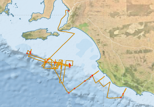
Voyage extents: 38° 32.1' S to 34° 46.3' S 136° 44.9' E to 140° 57.4' E Get voyage track shapefile Get CSV
Marlin Metadata:-
Participants - on ship:-
| Name | Role | Organisation |
|---|---|---|
| Bobbie Rice | University of Adelaide | |
| Chris von der Borch | Chief Investigator | Flinders University |
| Dave Vaudrey | Cruise Manager | CSIRO Division of Oceanography |
| Erik Madsen | CSIRO Division of Oceanography | |
| Graham Evans | Flinders University | |
| Margaret Fuller | University of Adelaide | |
| Noel James | Queens University, Ontario | |
| Tom Boreen | Queens University, Ontario | |
| Tony Belperio | SA Dept of Mines and Energy | |
| Vic Gostin | University of Adelaide | |
| Vicki Drapala | Australian National University | |
| Yvonne Bone | University of Adelaide |
This list includes those that may have only been on part of the voyage. See voyage reports on 'Reports and Maps' tab for details.
Marine National Facility Reports - plans, summaries and data processing
-
FR199102 Voyage Summary
- includes preliminary results, voyage narrative, types of data collected with C77/ROSCOP codes.
-
FR199102 Voyage Plan
- includes objectives, investigator details, proposed data collection, voyage track and equipment to be used.
-

Publications, reports and datasets from this voyage.
Journal Article
- Bone, Yvonne,James, Noel P. (1993) Bryozoans as carbonate sediment producers on the cool-water Lacepede Shelf, southern Australia. Sedimentary Geology 86 pp247-271. 10.1016/0037-0738%2893%2990025-z
- Hageman, S. J.,Bone, Y.,McGowran, B.,James, N. P. (1995) Modern bryozoan assemblages and distribution on the cool‐water Lacepede Shelf, southern Australian margin. Australian Journal of Earth Sciences 42 pp571-580. 10.1080/08120099508728226
- Noel P. James, Yvonne Bone, T. Kurtis Kyser; (1997) Brachiopod δ18O values do reflect ambient oceanography: Lacepede Shelf, southern Australia. Geology 1997;; 25 (6): 551–554. 10.1130/0091-7613(1997)025<0551:BOVDRA>2.3.CO;2
- Y. Bone, N. P. James, T. K. Kyser (1992) Synsedimentary detrital dolomite in Quaternary cool-water carbonate sediments, Lacepede shelf, South Australia. Geology 1992;; 20 (2): 109–112 10.1130/0091-7613(1992)020<0109:SDDIQC>2.3.CO;2
Search for publications, reports and datasets from this and other voyages
Data publishing
This is a list of online datasets hosted by CSIRO. Other processed datasets hosted by collaborating organisations may be found on the 'Metadata' or "Reports, Publications and Maps' tab.
Use the Get data link on the right to extract data using the NCMI Data Trawler.
| Data Stream | Data Summary | Get data | ||||||||||||
|---|---|---|---|---|---|---|---|---|---|---|---|---|---|---|
| Underway |
|
Get Data from Trawler |
||||||||||||
| XBT Profile |
Deployments by start time:- Click on column header to sort. Use link on 'Deployment' to see full details. Use the CSV button at the bottom to export data (tab delimited).
Search for deployments from this voyage and others
| Deployment | Operation | Station | Cast | Gear | Project | Start and end times | Start Location | End Location | Depth range | Max Depth | Description | |||
|---|---|---|---|---|---|---|---|---|---|---|---|---|---|---|
| Underway System [details] | Simrad EA500 Echosounder | 108 | 1991-01-14 00:00 | 1991-01-29 23:55 | -34.8222 | 138.5120 | -38.4232 | 140.8630 | ||||||
| XBT Cast [details] | 108 | 1991-01-19 15:49 | -36.9898 | 137.5555 | 760 | |||||||||
| XBT Cast [details] | 108 | 1991-01-19 19:24 | -36.9053 | 137.6433 | 110 | |||||||||
| XBT Cast [details] | 108 | 1991-01-20 05:17 | -37.0247 | 137.9413 | 120 | |||||||||
| XBT Cast [details] | 108 | 1991-01-20 08:46 | -37.2050 | 138.5703 | 540 | |||||||||
| XBT Cast [details] | 108 | 1991-01-20 14:04 | -37.1283 | 138.5785 | 300 | |||||||||
| XBT Cast [details] | 108 | 1991-01-20 16:09 | -37.1208 | 138.5792 | 250 | |||||||||
| XBT Cast [details] | 108 | 1991-01-20 19:50 | -37.0800 | 138.5543 | 145 | |||||||||
| XBT Cast [details] | 108 | 1991-01-23 21:32 | -36.5652 | 136.9068 | 115 | |||||||||
| XBT Cast [details] | 108 | 1991-01-24 00:27 | -36.6318 | 136.9093 | 135 | |||||||||
| XBT Cast [details] | 108 | 1991-01-24 03:43 | -36.6282 | 136.7638 | 260 | |||||||||
| XBT Cast [details] | 108 | 1991-01-24 22:00 | -38.3183 | 138.5245 | 760 | |||||||||
| XBT Cast [details] | 108 | 1991-01-25 01:06 | -38.1258 | 138.7672 | 760 | |||||||||
| XBT Cast [details] | 108 | 1991-01-25 06:29 | -37.8038 | 139.2065 | 760 | |||||||||
| XBT Cast [details] | 108 | 1991-01-25 09:25 | -37.6318 | 139.4488 | 640 | |||||||||
| XBT Cast [details] | 108 | 1991-01-25 10:18 | -37.5727 | 139.5160 | 185 | |||||||||
| XBT Cast [details] | 108 | 1991-01-25 10:23 | -37.5672 | 139.5220 | 165 | |||||||||
| XBT Cast [details] | 108 | 1991-01-27 05:26 | -38.5072 | 140.7260 | 760 | |||||||||
| XBT Cast [details] | 108 | 1991-01-27 08:04 | -38.3540 | 140.8218 | 140 | |||||||||