Voyage details and related metadata, reports, events and data.
FR 03/89
(alternative identifier: FR198903)
- is a Marine National Facility ![]() voyage
voyage
Period: 1989-03-08 00:00 to 1989-03-22 00:00 Local
Duration: 14.00 days
From: Adelaide To: Adelaide
Region: South Australian waters
Ship: Franklin [details]
Description: Cruise FR 03/89 was undertaken for a geological (Quaternary history) and physical oceanography survey of Gulf St. Vincent and adjacent continental shelf, and also to recover four magnetometers, previously deployed off Robe (cruise FR 01/89) in South Australian waters. Survey methods included high resolution seismic profiles, dredges, vibrocores, sea bottom photographs, XBTs, CTD casts and other associated instrumentation. Approximately 475 nm of seismic line were recorded, three magnetometers were successfully recovered (other presumed lost), and numerous samples including water, biota, sediment and rock fragments were collected for analysis aboard and for laboratory study.
Leader: C. von der Borch (Flinders Univ.) & V. Gostin (Univ. Adelaide)
Project: National Facility External Users: C. von der Borch (Flinders University) [details]
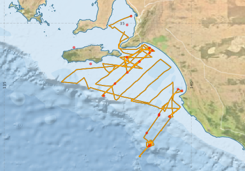
Voyage extents: 38° 34.9' S to 34° 47.6' S 136° 31.2' E to 139° 45.7' E Get voyage track shapefile Get CSV
Marlin Metadata:-
Metadata from OBIS Australia datasets:- biological data is published via the OBIS-AU IPT server and delivered to one or more of OBIS, ALA and GBIF
Download from OBIS Australia IPT View at - Ocean Biodiversity Information System (OBIS) Atlas of Living Australia (ALA) GBIF
Participants - on ship:-
| Name | Role | Organisation |
|---|---|---|
| Bobbie Rice | University of Adelaide | |
| Chris von der Borch | Co-Chief Scientist | Flinders University |
| Dave Vaudrey | Cruise Manager | CSIRO Division of Oceanography |
| Erik Madsen | CSIRO Division of Oceanography | |
| Graham Heinson | Research School of Earth Sciences, ANU | |
| Kim Gaard | SA Dept of Mines and Energy | |
| Liz Barrett | Flinders University | |
| Noel James | Queens University, Ontario | |
| Tony White | Flinders University | |
| Vic Gostin | Co-Chief Scientist | University of Adelaide |
| Yvonne Bone | University of Adelaide |
This list includes those that may have only been on part of the voyage. See voyage reports on 'Reports and Maps' tab for details.
Marine National Facility Reports - plans, summaries and data processing
-
FR198903 Voyage Summary
- includes preliminary results, voyage narrative, types of data collected with C77/ROSCOP codes.
-
FR198903 Voyage Plan
- includes objectives, investigator details, proposed data collection, voyage track and equipment to be used.
-

Publications, reports and datasets from this voyage.
IPT Resource
- Seabird observations in Australian and adjacent seas from voyages of the RV Franklin, RV Southern Surveyor, Southern Supporter and RV Aurora Australis (1988-2012) (Darwin Core Archive) External link to reference
Journal Article
- Bone, Yvonne,James, Noel P. (1993) Bryozoans as carbonate sediment producers on the cool-water Lacepede Shelf, southern Australia. Sedimentary Geology 86 pp247-271. 10.1016/0037-0738%2893%2990025-z
- Hageman, S. J.,Bone, Y.,McGowran, B.,James, N. P. (1995) Modern bryozoan assemblages and distribution on the cool‐water Lacepede Shelf, southern Australian margin. Australian Journal of Earth Sciences 42 pp571-580. 10.1080/08120099508728226
- Noel P. James, Yvonne Bone, T. Kurtis Kyser; (1997) Brachiopod δ18O values do reflect ambient oceanography: Lacepede Shelf, southern Australia. Geology 1997;; 25 (6): 551–554. 10.1130/0091-7613(1997)025<0551:BOVDRA>2.3.CO;2
- Y. Bone, N. P. James, T. K. Kyser (1992) Synsedimentary detrital dolomite in Quaternary cool-water carbonate sediments, Lacepede shelf, South Australia. Geology 1992;; 20 (2): 109–112 10.1130/0091-7613(1992)020<0109:SDDIQC>2.3.CO;2
Search for publications, reports and datasets from this and other voyages
Data publishing
This is a list of online datasets hosted by CSIRO. Other processed datasets hosted by collaborating organisations may be found on the 'Metadata' or "Reports, Publications and Maps' tab.
Use the Get data link on the right to extract data using the NCMI Data Trawler.
| Data Stream | Data Summary | Get data | ||||||||||||
|---|---|---|---|---|---|---|---|---|---|---|---|---|---|---|
| Marine biodiversity observations and/or samples |
|
Get Data from Trawler |
||||||||||||
| CTD profile |
|
Get Data from Trawler |
||||||||||||
| Hydrology |
|
Get Data from Trawler |
||||||||||||
| Underway |
|
Get Data from Trawler |
||||||||||||
| XBT Profile |
Deployments by start time:- Click on column header to sort. Use link on 'Deployment' to see full details. Use the CSV button at the bottom to export data (tab delimited).
Search for deployments from this voyage and others
| Deployment | Operation | Station | Cast | Gear | Project | Start and end times | Start Location | End Location | Depth range | Max Depth | Description | |||
|---|---|---|---|---|---|---|---|---|---|---|---|---|---|---|
| Underway System [details] | Simrad EA500 Echosounder | 108 | 1989-03-08 00:00 | 1989-03-21 23:55 | -34.8100 | 138.3870 | -35.2157 | 138.2150 | ||||||
| CTD Cast / Hydrology [details] | 1 | Cast 1 | 108 | 1989-03-12 02:42 | 1989-03-12 03:08 | -36.9457 | 137.6572 | -36.9463 | 137.6652 | 0 | ||||
| CTD Cast / Hydrology [details] | 1 | Cast 2 | 108 | 1989-03-12 08:05 | 1989-03-12 08:20 | -36.6197 | 137.9558 | -36.6207 | 137.9568 | 0 | ||||
| CTD Cast / Hydrology [details] | 1 | Cast 3 | 108 | 1989-03-12 11:26 | 1989-03-12 11:39 | -36.3205 | 138.2882 | -36.3215 | 138.2887 | 0 | ||||
| CTD Cast / Hydrology [details] | 1 | Cast 4 | 108 | 1989-03-12 14:56 | 1989-03-12 15:10 | -36.0287 | 138.6113 | -36.0300 | 138.6128 | 0 | ||||
| CTD Cast / Hydrology [details] | 1 | Cast 5 | 108 | 1989-03-12 18:40 | 1989-03-12 18:54 | -35.7302 | 138.9565 | -35.7297 | 138.9590 | 0 | ||||
| Sediment Sampling [details] | DR17A | 108 | 1989-03-13 00:00 | -35.0450 | 138.2800 | |||||||||
| XBT Cast [details] | 108 | 1989-03-16 09:29 | -38.2975 | 138.8583 | 75 | |||||||||
| XBT Cast [details] | 108 | 1989-03-16 09:42 | -38.2650 | 138.8920 | 310 | |||||||||
| XBT Cast [details] | 108 | 1989-03-16 23:06 | -37.9408 | 138.8052 | 760 | |||||||||
| XBT Cast [details] | 108 | 1989-03-17 01:56 | -37.4703 | 139.1308 | 75 | |||||||||
| XBT Cast [details] | 108 | 1989-03-17 02:06 | -37.4430 | 139.1382 | 465 | |||||||||
| XBT Cast [details] | 108 | 1989-03-18 09:23 | -37.5035 | 139.4187 | 110 | |||||||||
| Sediment Sampling [details] | DR68 | 108 | 1989-03-19 00:00 | -36.0883 | 137.3050 | |||||||||
| Sediment Sampling [details] | VHB1 | 108 | -36.8092 | 139.7475 | ||||||||||
| Sediment Sampling [details] | VH83 | 108 | -35.7958 | 138.8783 | ||||||||||
| Sediment Sampling [details] | VH82 | 108 | -35.6637 | 138.8800 | ||||||||||
| Sediment Sampling [details] | VH81 | 108 | -35.6500 | 136.8583 | ||||||||||
| Sediment Sampling [details] | VHB2 | 108 | -36.7657 | 139.6403 | ||||||||||
| Sediment Sampling [details] | VH80 | 108 | -35.9100 | 138.2733 | ||||||||||