Voyage details and related metadata, reports, events and data.
FR 08/88
(alternative identifier: FR198808)
- is a Marine National Facility ![]() voyage
voyage
Period: 1988-10-06 00:00 to 1988-10-17 00:00 Local
Duration: 11.00 days
From: Townsville To: Sydney
Region: Tasman Sea
Ship: Franklin [details]
Description: Cruise FR 08/88 was undertaken to dredge samples of volcanic rock from the Lord Howe Seamount and Tasmantid Seamount chains in the Tasman Sea, to provide the basis for geochronological, geochemical and petrological studies of the seamounts to further elucidate the evolution and origin of these two parallel seamount chains. Dredged samples included weathered basalt, limestone, pumice, shell and coral debris. These samples will be studied by appropriate scientists and some material will be forwarded to specialists in the Australian Museum, Sydney.
Leader: I. McDougall (ANU) & D. Green (University of Tasmania)
Project: National Facility External Users: I. McDougall (ANU) [details]
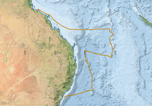
Voyage extents: 33° 47.3' S to 19° 10.6' S 147° 12.1' E to 159° 40.1' E Get voyage track shapefile Get CSV
Marlin Metadata:-
Metadata from OBIS Australia datasets:- biological data is published via the OBIS-AU IPT server and delivered to one or more of OBIS, ALA and GBIF
Download from OBIS Australia IPT View at - Ocean Biodiversity Information System (OBIS)
Download from OBIS Australia IPT View at - Ocean Biodiversity Information System (OBIS) Atlas of Living Australia (ALA) GBIF
Participants - on ship:-
| Name | Role | Organisation |
|---|---|---|
| AJ Crawford | Geology Dept, UTAS | |
| DB Patterson | Research School of Earth Sciences, ANU | |
| Dave Vaudrey | Cruise Manager | CSIRO Division of Oceanography |
| Ian McDougall | Chief Scientist | Australian National University |
| JD Woodhead | Research School of Earth Sciences, ANU | |
| Phil Adams | CSIRO Division of Oceanography | |
| SM Eggins | Geology Dept, UTAS | |
| Trevor Falloon | Geology Dept, UTAS |
This list includes those that may have only been on part of the voyage. See voyage reports on 'Reports and Maps' tab for details.
Marine National Facility Reports - plans, summaries and data processing
-
FR198808 Voyage Summary
- includes preliminary results, voyage narrative, types of data collected with C77/ROSCOP codes.
-
FR198808 Voyage Plan
- includes objectives, investigator details, proposed data collection, voyage track and equipment to be used.
-

Publications, reports and datasets from this voyage.
IPT Resource
- Global benthic biogeographical regions and macroecological drivers for ophiuroids [Data set] (Darwin Core Archive) External link to reference
- Seabird observations in Australian and adjacent seas from voyages of the RV Franklin, RV Southern Surveyor, Southern Supporter and RV Aurora Australis (1988-2012) (Darwin Core Archive) External link to reference
Journal Article
- Eggins, S.M.,Green, D.H.,Falloon, T.J. (1991) The Tasmantid Seamounts: shallow melting and contamination of an EM1 mantle plume. Earth and Planetary Science Letters 107 pp448-462. 10.1016/0012-821x%2891%2990092-v
Search for publications, reports and datasets from this and other voyages
Data publishing
This is a list of online datasets hosted by CSIRO. Other processed datasets hosted by collaborating organisations may be found on the 'Metadata' or "Reports, Publications and Maps' tab.
Use the Get data link on the right to extract data using the NCMI Data Trawler.
| Data Stream | Data Summary | Get data | ||||||||||||
|---|---|---|---|---|---|---|---|---|---|---|---|---|---|---|
| Marine biodiversity observations and/or samples |
|
Get Data from Trawler |
||||||||||||
| Underway |
|
Get Data from Trawler |
Deployments by start time:- Click on column header to sort. Use link on 'Deployment' to see full details. Use the CSV button at the bottom to export data (tab delimited).
Search for deployments from this voyage and others
| Deployment | Operation | Station | Cast | Gear | Project | Start and end times | Start Location | End Location | Depth range | Max Depth | Description | |||
|---|---|---|---|---|---|---|---|---|---|---|---|---|---|---|
| Underway System [details] | Simrad EA500 Echosounder | 115 | 1988-10-06 00:00 | 1988-10-17 23:55 | -19.1770 | 147.2020 | -33.7882 | 151.4900 | ||||||