Voyage details and related metadata, reports, events and data.
FR 02/88
(alternative identifier: FR198802)
- is a Marine National Facility ![]() voyage
voyage
Period: 1988-02-19 00:00 to 1988-03-06 00:00 Local
Duration: 16.00 days
From: Cairns To: Darwin
Region: Gulf of Carpentaria
Ship: Franklin [details]
Description: Cruise FR 02/88 was undertaken to investigate the roles that tidal and wind mixing of water masses and the presence of extensive seagrass beds may play in determining nutrient distribution and cycling in the Gulf of Carpentaria. Primary and bacterial productivity was also investigated. Survey methods included Seastar sediment traps, XBT's, CTD casts (including light meter), ADCP, Smith-MacIntyre grab, phytoplankton and zooplankton drop nets and other associated instrumentation. Numerous water, biological and sediment samples were collected for analysis on board and for laboratory study.
Leader: P. Nichols, A. Forbes & P. Rothlisberg (CSIRO)
Project: Mesoscale and Continental Shelf Oceanography 1981-1989 [details]
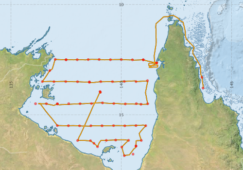
Voyage extents: 16° 52.3' S to 10° 29.9' S 136° 14.3' E to 143° 42.4' E Get voyage track shapefile Get CSV
Marlin Metadata:-
Metadata from OBIS Australia datasets:- biological data is published via the OBIS-AU IPT server and delivered to one or more of OBIS, ALA and GBIF
Download from OBIS Australia IPT View at - Ocean Biodiversity Information System (OBIS) Atlas of Living Australia (ALA) GBIF
Participants - on ship:-
| Name | Role | Organisation |
|---|---|---|
| Bruce Barker | CSIRO Division of Oceanography | |
| Chris Jackson | CSIRO Division of Fisheries | |
| Dave Vaudrey | CSIRO Division of Oceanography | |
| David Moriarty | CSIRO Division of Fisheries | |
| Erik Madsen | CSIRO Division of Oceanography | |
| Fred Boland | CSIRO Division of Oceanography | |
| Jeff Dunn | CSIRO Division of Oceanography | |
| Ken Suber | CSIRO Division of Oceanography | |
| Patrick Deprez | CSIRO Division of Oceanography | |
| Peter Nichols | Chief Scientist | CSIRO Division of Oceanography |
| Peter Pollard | CSIRO Division of Fisheries | |
| Peter Rothlisberg | CSIRO Division of Fisheries |
This list includes those that may have only been on part of the voyage. See voyage reports on 'Reports and Maps' tab for details.
Marine National Facility Reports - plans, summaries and data processing
-
FR198802 Voyage Summary
- includes preliminary results, voyage narrative, types of data collected with C77/ROSCOP codes.
-
FR198802 Voyage Plan
- includes objectives, investigator details, proposed data collection, voyage track and equipment to be used.
-

Publications, reports and datasets from this voyage.
Dataset
- CSIRO (2013): RV Franklin 2/88 Post Cruise Project Data. v1. CSIRO. Data Collection. 10.4225/08/51396c1844f13
IPT Resource
- Seabird observations in Australian and adjacent seas from voyages of the RV Franklin, RV Southern Surveyor, Southern Supporter and RV Aurora Australis (1988-2012) (Darwin Core Archive) External link to reference
Journal Article
- Mackey, D.J., Butler, E.C.V., Nichols, P.D., Higgins, H.W. (1992). High-Resolution Measurements of pH, Fluorescence and Turbidity in Sea Water. In: Ilyichev, V.I., Anikiev, V.V. (eds) Oceanic and Anthropogenic Controls of Life in the Pacific Ocean. The GeoJournal Library, vol 21. Springer, Dordrecht. 10.1007/978-94-011-2773-8_24
- Rothlisberg, PC,Pollard, PC,Nichols, PD,Moriarty, DJW,Forbes, AMG,Jackson, CJ,Vaudrey, D (1994) Phytoplankton community structure and productivity in relation to the hydrological regime of the Gulf of Carpentaria, Australia, in summer. Marine and Freshwater Research 45 pp265-. 10.1071/MF9940265
Search for publications, reports and datasets from this and other voyages
Data publishing
This is a list of online datasets hosted by CSIRO. Other processed datasets hosted by collaborating organisations may be found on the 'Metadata' or "Reports, Publications and Maps' tab.
Use the Get data link on the right to extract data using the NCMI Data Trawler.
| Data Stream | Data Summary | Get data | ||||||||||||||
|---|---|---|---|---|---|---|---|---|---|---|---|---|---|---|---|---|
| ADCP Data |
|
Get Data from Trawler Download ASCII dataset fr8802adcp.zip Download NetCDF dataset fr8802adcpCDF.zip |
||||||||||||||
| Marine biodiversity observations and/or samples |
|
Get Data from Trawler |
||||||||||||||
| CTD profile |
|
Get Data from Trawler |
||||||||||||||
| Hydrology |
|
Get Data from Trawler |
||||||||||||||
| Underway |
|
Get Data from Trawler |
Deployments by start time:- Click on column header to sort. Use link on 'Deployment' to see full details. Use the CSV button at the bottom to export data (tab delimited).
Search for deployments from this voyage and others
| Deployment | Operation | Station | Cast | Gear | Project | Start and end times | Start Location | End Location | Depth range | Max Depth | Description | |||
|---|---|---|---|---|---|---|---|---|---|---|---|---|---|---|
| Underway System [details] | Anemometer,Anemometer,Anemometer,Gyro-MK 10,RIMCO vane driving potentiometer,RIMCO vane driving potentiometer,Ships log,Simrad EA500 Echosounder,Temperature sensor-AD590J,ThermoSalinoGraph (TSG),ThermoSalinoGraph (TSG) | 1524 | 1988-02-19 00:00 | 1988-03-06 23:55 | -13.7952 | 143.7060 | -14.0300 | 139.0500 | ||||||
| ADCP Data [details] | RDI VM-150 Acoustic Doppler current profiler | 1524 | 1988-02-19 22:40 | 1988-03-03 04:20 | -13.3100 | 143.6560 | -13.3860 | 138.7710 | 53.4 | |||||
| CTD Cast / Hydrology [details] | 1 | Cast 1 | 1524 | 1988-02-21 03:57 | 1988-02-21 04:26 | -12.6555 | 141.6047 | -12.6602 | 141.6093 | 0 | ||||
| CTD Cast / Hydrology [details] | 1 | Cast 2 | 1524 | 1988-02-21 18:52 | 1988-02-21 19:06 | -12.6488 | 141.6005 | 0 | ||||||
| CTD Cast / Hydrology [details] | 1 | Cast 3 | 1524 | 1988-02-22 22:40 | 1988-02-22 23:05 | -12.5070 | 140.9977 | -12.5113 | 140.9972 | 0 | ||||
| CTD Cast [details] | 1 | Cast 4 | 1524 | 1988-02-22 23:22 | 1988-02-22 23:33 | -12.5138 | 140.9957 | -12.5150 | 140.9945 | 0 | ||||
| CTD Cast / Hydrology [details] | 1 | Cast 5 | 1524 | 1988-02-23 02:16 | 1988-02-23 02:36 | -12.5108 | 140.5067 | -12.5145 | 140.5052 | 0 | ||||
| CTD Cast / Hydrology [details] | 1 | Cast 6 | 1524 | 1988-02-23 05:16 | 1988-02-23 05:38 | -12.5000 | 139.9987 | -12.4983 | 139.9977 | 0 | ||||
| CTD Cast / Hydrology [details] | 1 | Cast 7 | 1524 | 1988-02-23 08:38 | 1988-02-23 09:01 | -12.5057 | 139.5078 | -12.5062 | 139.5093 | 0 | ||||
| CTD Cast / Hydrology [details] | 1 | Cast 8 | 1524 | 1988-02-23 12:04 | 1988-02-23 12:26 | -12.4968 | 138.9960 | -12.4970 | 138.9950 | 0 | ||||
| CTD Cast / Hydrology [details] | 1 | Cast 9 | 1524 | 1988-02-23 14:57 | 1988-02-23 15:21 | -12.4995 | 138.4998 | -12.5022 | 138.5005 | 0 | ||||
| CTD Cast / Hydrology [details] | 1 | Cast 10 | 1524 | 1988-02-23 18:49 | 1988-02-23 19:10 | -12.5045 | 138.0022 | -12.5088 | 138.0045 | 0 | ||||
| CTD Cast / Hydrology [details] | 1 | Cast 11 | 1524 | 1988-02-23 21:56 | 1988-02-23 22:15 | -12.5042 | 137.4995 | -12.5065 | 137.4992 | 0 | ||||
| CTD Cast [details] | 1 | Cast 12 | 1524 | 1988-02-23 22:56 | 1988-02-23 23:05 | -12.5110 | 137.4967 | -12.5120 | 137.4965 | 0 | ||||
| CTD Cast / Hydrology [details] | 1 | Cast 14 | 1524 | 1988-02-24 02:24 | 1988-02-24 02:45 | -12.4918 | 137.0050 | -12.4942 | 137.0040 | 0 | ||||
| CTD Cast / Hydrology [details] | 1 | Cast 15 | 1524 | 1988-02-24 05:44 | 1988-02-24 06:04 | -12.9987 | 136.7582 | -13.0020 | 136.7572 | 0 | ||||
| CTD Cast / Hydrology [details] | 1 | Cast 16 | 1524 | 1988-02-24 09:10 | 1988-02-24 09:28 | -13.4990 | 136.4180 | -13.4992 | 136.4162 | 0 | ||||
| CTD Cast / Hydrology [details] | 1 | Cast 17 | 1524 | 1988-02-24 12:28 | 1988-02-24 12:45 | -13.5015 | 136.9478 | -13.5018 | 136.9470 | 0 | ||||
| CTD Cast / Hydrology [details] | 1 | Cast 18 | 1524 | 1988-02-24 15:33 | 1988-02-24 15:47 | -13.4977 | 137.4825 | -13.4970 | 137.4812 | 0 | ||||
| CTD Cast / Hydrology [details] | 1 | Cast 19 | 1524 | 1988-02-24 18:56 | 1988-02-24 19:17 | -13.5042 | 138.0168 | -13.5063 | 138.0152 | 0 | ||||
| CTD Cast / Hydrology [details] | 1 | Cast 20 | 1524 | 1988-02-24 22:08 | 1988-02-24 22:36 | -13.5092 | 138.5587 | -13.5152 | 138.5577 | 0 | ||||
| CTD Cast [details] | 1 | Cast 21 | 1524 | 1988-02-24 23:46 | 1988-02-24 23:52 | -13.5338 | 138.5568 | -13.5355 | 138.5568 | 0 | ||||
| CTD Cast / Hydrology [details] | 1 | Cast 22 | 1524 | 1988-02-25 02:42 | 1988-02-25 03:05 | -13.4990 | 139.0648 | -13.5048 | 139.0663 | 0 | ||||
| CTD Cast / Hydrology [details] | 1 | Cast 23 | 1524 | 1988-02-25 05:47 | 1988-02-25 06:06 | -13.5013 | 139.5995 | -13.5037 | 139.5997 | 0 | ||||
| CTD Cast / Hydrology [details] | 1 | Cast 24 | 1524 | 1988-02-25 09:06 | 1988-02-25 09:28 | -13.4928 | 140.1357 | -13.4908 | 140.1357 | 0 | ||||
| CTD Cast / Hydrology [details] | 1 | Cast 25 | 1524 | 1988-02-25 12:17 | 1988-02-25 12:37 | -13.4985 | 140.6673 | -13.4953 | 140.6672 | 0 | ||||
| CTD Cast / Hydrology [details] | 1 | Cast 26 | 1524 | 1988-02-25 15:39 | 1988-02-25 15:59 | -13.4555 | 141.1877 | 0 | ||||||
| CTD Cast / Hydrology [details] | 1 | Cast 27 | 1524 | 1988-02-25 21:12 | 1988-02-25 21:29 | -14.5058 | 141.2007 | -14.5137 | 141.2022 | 0 | ||||
| CTD Cast [details] | 1 | Cast 28 | 1524 | 1988-02-25 23:29 | 1988-02-25 23:35 | -14.5272 | 140.8930 | -14.5282 | 140.8925 | 0 | ||||
| CTD Cast / Hydrology [details] | 1 | Cast 29 | 1524 | 1988-02-26 01:07 | 1988-02-26 01:30 | -14.4987 | 140.6830 | 0 | ||||||
| CTD Cast / Hydrology [details] | 1 | Cast 30 | 1524 | 1988-02-26 04:08 | 1988-02-26 04:26 | -14.5097 | 140.1850 | -14.5137 | 140.1860 | 0 | ||||
| CTD Cast / Hydrology [details] | 1 | Cast 31 | 1524 | 1988-02-26 07:33 | 1988-02-26 07:55 | -14.4945 | 139.6613 | -14.4940 | 139.6622 | 0 | ||||
| CTD Cast / Hydrology [details] | 1 | Cast 32 | 1524 | 1988-02-26 10:28 | 1988-02-26 10:51 | -14.4630 | 139.1493 | -14.4633 | 139.1493 | 0 | ||||
| CTD Cast / Hydrology [details] | 1 | Cast 33 | 1524 | 1988-02-26 13:50 | 1988-02-26 14:10 | -14.4955 | 138.6495 | -14.4922 | 138.6500 | 0 | ||||
| CTD Cast / Hydrology [details] | 1 | Cast 34 | 1524 | 1988-02-26 16:54 | 1988-02-26 17:13 | -14.5032 | 138.1317 | -14.5040 | 138.1312 | 0 | ||||
| CTD Cast / Hydrology [details] | 1 | Cast 35 | 1524 | 1988-02-26 20:21 | 1988-02-26 20:41 | -14.5002 | 137.6167 | 0 | ||||||
| CTD Cast / Hydrology [details] | 1 | Cast 36 | 1524 | 1988-02-26 23:24 | 1988-02-26 23:42 | -14.5030 | 137.1080 | -14.5077 | 137.1042 | 0 | ||||
| CTD Cast [details] | 1 | Cast 37 | 1524 | 1988-02-27 00:02 | 1988-02-27 00:06 | -14.5123 | 137.0992 | -14.5135 | 137.0988 | 0 | ||||
| CTD Cast / Hydrology [details] | 1 | Cast 38 | 1524 | 1988-02-27 02:53 | 1988-02-27 03:11 | -14.5015 | 136.6063 | 0 | ||||||
| CTD Cast / Hydrology [details] | 1 | Cast 39 | 1524 | 1988-02-27 05:48 | 1988-02-27 06:03 | -14.5015 | 136.1127 | 0 | ||||||
| CTD Cast / Hydrology [details] | 1 | Cast 40 | 1524 | 1988-02-27 14:09 | 1988-02-27 14:26 | -15.4952 | 137.1000 | -15.4957 | 137.1008 | 0 | ||||
| CTD Cast / Hydrology [details] | 1 | Cast 41 | 1524 | 1988-02-27 17:13 | 1988-02-27 17:33 | -15.4992 | 137.6035 | -15.4985 | 137.6052 | 0 | ||||
| CTD Cast / Hydrology [details] | 1 | Cast 42 | 1524 | 1988-02-27 20:03 | 1988-02-27 20:23 | -15.5033 | 138.1073 | -15.5058 | 138.1105 | 0 | ||||
| CTD Cast / Hydrology [details] | 1 | Cast 43 | 1524 | 1988-02-27 23:18 | 1988-02-27 23:51 | -15.5018 | 138.6212 | 0 | ||||||
| CTD Cast / Hydrology [details] | 1 | Cast 44 | 1524 | 1988-02-28 02:35 | 1988-02-28 02:52 | -15.5010 | 139.1268 | 0 | ||||||
| CTD Cast / Hydrology [details] | 1 | Cast 45 | 1524 | 1988-02-28 05:34 | 1988-02-28 05:53 | -15.4952 | 139.6485 | -15.5008 | 139.6512 | 0 | ||||
| CTD Cast / Hydrology [details] | 1 | Cast 46 | 1524 | 1988-02-28 08:26 | 1988-02-28 08:48 | -15.5030 | 140.1597 | -15.5027 | 140.1618 | 0 | ||||
| CTD Cast / Hydrology [details] | 1 | Cast 47 | 1524 | 1988-02-28 11:33 | 1988-02-28 11:54 | -15.4935 | 140.6665 | -15.4887 | 140.6673 | 0 | ||||
| CTD Cast / Hydrology [details] | 1 | Cast 48 | 1524 | 1988-02-28 14:17 | 1988-02-28 14:37 | -15.4988 | 141.1132 | -15.4960 | 141.1093 | 0 | ||||
| CTD Cast / Hydrology [details] | 1 | Cast 49 | 1524 | 1988-02-28 20:04 | 1988-02-28 20:21 | -16.1708 | 140.9088 | -16.1717 | 140.9118 | 0 | ||||
| CTD Cast / Hydrology [details] | 1 | Cast 50 | 1524 | 1988-02-28 23:05 | 1988-02-28 23:21 | -16.4208 | 140.6640 | -16.4218 | 140.6655 | 0 | ||||
| CTD Cast [details] | 1 | Cast 51 | 1524 | 1988-02-28 23:51 | 1988-02-28 23:53 | -16.4255 | 140.6703 | -16.4258 | 140.6707 | 0 | ||||
| CTD Cast / Hydrology [details] | 1 | Cast 52 | 1524 | 1988-02-29 02:46 | 1988-02-29 02:58 | -16.7900 | 140.5348 | 0 | ||||||
| CTD Cast / Hydrology [details] | 1 | Cast 53 | 1524 | 1988-02-29 05:21 | 1988-02-29 05:43 | -16.8597 | 140.1373 | -16.8660 | 140.1398 | 0 | ||||
| CTD Cast / Hydrology [details] | 1 | Cast 54 | 1524 | 1988-02-29 08:21 | 1988-02-29 08:41 | -16.4645 | 140.0207 | -16.4663 | 140.0192 | 0 | ||||
| CTD Cast / Hydrology [details] | 1 | Cast 55 | 1524 | 1988-02-29 10:57 | 1988-02-29 11:18 | -16.1627 | 140.3335 | -16.1600 | 140.3338 | 0 | ||||
| CTD Cast / Hydrology [details] | 1 | Cast 56 | 1524 | 1988-02-29 14:49 | 1988-02-29 15:10 | -16.1512 | 139.7467 | -16.1488 | 139.7438 | 0 | ||||
| CTD Cast / Hydrology [details] | 1 | Cast 57 | 1524 | 1988-02-29 17:30 | 1988-02-29 17:45 | -16.1647 | 139.3207 | -16.1633 | 139.3208 | 0 | ||||
| CTD Cast / Hydrology [details] | 1 | Cast 58 | 1524 | 1988-02-29 21:23 | 1988-02-29 21:38 | -16.4557 | 138.9227 | -16.4570 | 138.9247 | 0 | ||||
| CTD Cast [details] | 1 | Cast 59 | 1524 | 1988-02-29 23:32 | 1988-02-29 23:34 | -16.2988 | 138.7640 | -16.2990 | 138.7643 | 0 | ||||
| CTD Cast / Hydrology [details] | 1 | Cast 60 | 1524 | 1988-03-01 01:12 | 1988-03-01 01:29 | -16.1800 | 138.6020 | -16.1825 | 138.6062 | 0 | ||||
| CTD Cast / Hydrology [details] | 1 | Cast 61 | 1524 | 1988-03-01 04:52 | 1988-03-01 05:08 | -16.1710 | 138.0183 | -16.1717 | 138.0192 | 0 | ||||
| CTD Cast [details] | 1 | Cast 62 | 1524 | 1988-03-01 19:09 | 1988-03-01 19:11 | -13.9493 | 139.0347 | -13.9498 | 139.0348 | 0 | ||||
| CTD Cast / Hydrology [details] | 1 | Cast 63 | 1524 | 1988-03-02 02:32 | 1988-03-02 02:55 | -13.9852 | 139.0545 | -14.0012 | 139.0672 | 0 | ||||