Voyage details and related metadata, reports, events and data.
FR 01/88
(alternative identifier: FR198801)
- is a Marine National Facility ![]() voyage
voyage
Period: 1988-01-08 00:00 to 1988-01-28 00:00 Local
Duration: 20.00 days
From: Cairns To: Cairns
Region: Woodlark Basin, PNG
Ship: Franklin [details]
Description: Cruise FR 01/88 (also known as PACLARK II) was undertaken to locate evidence of hydrothermal activity in the Western Woodlark Basin (east of Papua New Guinea) and Goodenough Bay, and to map submarine geology in an area of ocean ridge propagation into a continental margin. Survey methods included bathymetric profiling, magnetometer surveys, dredgers and gravity corers, a deep-tow camera system, and CTD casts with other associated instrumentation including a transmissometer. Numerous rock, sediment and water samples were collected for laboratory study. Related cruises are FR 02/86, FR 08/91, HMAS Cook - PACLARK III and RV Akademik Mstislav Keldysh and MIR submersibles - SUPACLARK.
Leader: R. Binns (CSIRO Exploration & Mining) & S. Scott (Univ. of Toronto)
Project: National Facility External Users: R. Binns (CSIRO Exploration & Mining) [details]
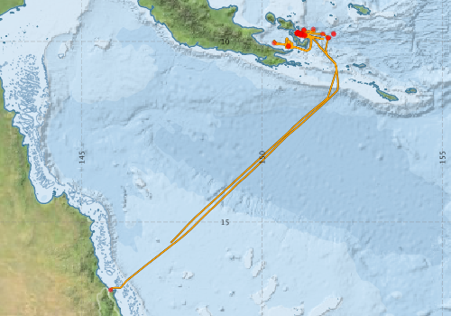
Voyage extents: 16° 52.8' S to 9° 38.8' S 145° 48.3' E to 152° 06.5' E Get voyage track shapefile Get CSV
Marlin Metadata:-
Metadata from OBIS Australia datasets:- biological data is published via the OBIS-AU IPT server and delivered to one or more of OBIS, ALA and GBIF
Download from OBIS Australia IPT View at - Ocean Biodiversity Information System (OBIS)
Download from OBIS Australia IPT View at - Ocean Biodiversity Information System (OBIS) Atlas of Living Australia (ALA) GBIF
Participants - on ship:-
| Name | Role | Organisation |
|---|---|---|
| Dave Cousens | CSIRO Exploration Geoscience | |
| Dave Edwards | CSIRO Division of Oceanography | |
| Dave Whitford | CSIRO Exploration Geoscience | |
| Dick Chase | University of British Columbia | |
| Eric Finlayson | PNG Geological Survey | |
| Graeme Weller | Antarctic Cooperative Research Centre | |
| Ian Clark | University of British Columbia | |
| Lasark Joseph | PNG Geological Survey | |
| Malcolm Wallace | Antarctic Cooperative Research Centre | |
| Mirek Benes | University of Toronto | |
| Ray Binns | Chief Scientist | CSIRO Exploration Geoscience |
| Steve Scott | University of Toronto |
This list includes those that may have only been on part of the voyage. See voyage reports on 'Reports and Maps' tab for details.
Marine National Facility Reports - plans, summaries and data processing
-
FR198801 Voyage Summary
- includes preliminary results, voyage narrative, types of data collected with C77/ROSCOP codes.
-
FR198801 Voyage Plan
- includes objectives, investigator details, proposed data collection, voyage track and equipment to be used.
-

Publications, reports and datasets from this voyage.
IPT Resource
- Global benthic biogeographical regions and macroecological drivers for ophiuroids [Data set] (Darwin Core Archive) External link to reference
- Seabird observations in Australian and adjacent seas from voyages of the RV Franklin, RV Southern Surveyor, Southern Supporter and RV Aurora Australis (1988-2012) (Darwin Core Archive) External link to reference
Journal Article
- Cheshire, N. (2010) Procellariiformes observed around Papua New Guinea including the Bismarck Archipelago from 1985 to 2007. South Australian Ornithologist Vol 36, parts 1 &2 (p. 9-24)
Search for publications, reports and datasets from this and other voyages
Data publishing
This is a list of online datasets hosted by CSIRO. Other processed datasets hosted by collaborating organisations may be found on the 'Metadata' or "Reports, Publications and Maps' tab.
Use the Get data link on the right to extract data using the NCMI Data Trawler.
| Data Stream | Data Summary | Get data | ||||||||||||
|---|---|---|---|---|---|---|---|---|---|---|---|---|---|---|
| Marine biodiversity observations and/or samples |
|
Get Data from Trawler |
||||||||||||
| CTD profile | No data | |||||||||||||
| Underway |
|
Get Data from Trawler |
Deployments by start time:- Click on column header to sort. Use link on 'Deployment' to see full details. Use the CSV button at the bottom to export data (tab delimited).
Search for deployments from this voyage and others
| Deployment | Operation | Station | Cast | Gear | Project | Start and end times | Start Location | End Location | Depth range | Max Depth | Description | |||
|---|---|---|---|---|---|---|---|---|---|---|---|---|---|---|
| Underway System [details] | 133 | 1988-01-08 00:00 | 1988-01-28 23:55 | -16.8802 | 145.8050 | -15.5752 | 147.4690 | |||||||
| Sediment Sampling [details] | D-14 | 133 | 1988-01-11 14:45 | -9.8197 | 151.1770 | 1530 | ||||||||
| Sediment Sampling [details] | D-15 | 133 | 1988-01-11 19:27 | -9.8528 | 151.1653 | 1460 | ||||||||
| Sediment Sampling [details] | D-16 | 133 | 1988-01-12 23:05 | -9.8033 | 151.0650 | 1516 | ||||||||
| Sediment Sampling [details] | D-17 | 133 | 1988-01-13 02:16 | -9.8400 | 151.0800 | 1350 | ||||||||
| Sediment Sampling [details] | D-18 | 133 | 1988-01-13 04:40 | -9.8167 | 151.1333 | 1550 | ||||||||
| Sediment Sampling [details] | D-19 | 133 | 1988-01-13 07:10 | -9.7767 | 151.0967 | 1482 | ||||||||
| Sediment Sampling [details] | D-20 | 133 | 1988-01-13 09:50 | -9.7933 | 151.0300 | 1345 | ||||||||
| Sediment Sampling [details] | D-21 | 133 | 1988-01-14 00:12 | -9.6800 | 151.1633 | 2270 | ||||||||
| Sediment Sampling [details] | D-22 | 133 | 1988-01-15 08:11 | -10.1450 | 150.7333 | 1300 | ||||||||
| Sediment Sampling [details] | PC-1 | 133 | 1988-01-16 03:29 | -10.0433 | 150.3400 | 1335 | ||||||||
| Sediment Sampling [details] | PC-2 | 133 | 1988-01-16 06:55 | -10.1133 | 150.7367 | 1385 | ||||||||
| Sediment Sampling [details] | D-23 | 133 | 1988-01-17 01:35 | -9.6615 | 151.4218 | 2110 | ||||||||
| Sediment Sampling [details] | D-24 | 133 | 1988-01-17 19:07 | -9.7875 | 150.9860 | 870 | ||||||||
| Sediment Sampling [details] | D-25 | 133 | 1988-01-18 03:50 | -9.7560 | 150.9843 | 962 | ||||||||
| Sediment Sampling [details] | D-26 | 133 | 1988-01-18 18:57 | -9.7762 | 150.9650 | 880 | ||||||||
| Sediment Sampling [details] | D-27 | 133 | 1988-01-19 04:41 | -9.7497 | 150.9983 | 860 | ||||||||
| Sediment Sampling [details] | D-28 | 133 | 1988-01-19 06:58 | -9.7370 | 150.9927 | 734 | ||||||||
| Sediment Sampling [details] | D-29 | 133 | 1988-01-20 05:35 | -9.8013 | 151.0828 | 1510 | ||||||||
| Sediment Sampling [details] | D-30 | 133 | 1988-01-20 08:25 | -9.7998 | 151.0838 | 1498 | ||||||||
| Sediment Sampling [details] | PC-3 | 133 | 1988-01-21 03:09 | -9.8017 | 151.9933 | 1185 | ||||||||
| Sediment Sampling [details] | D-31 | 133 | 1988-01-21 06:20 | -9.8097 | 151.0800 | 1472 | ||||||||
| Sediment Sampling [details] | D-32 | 133 | 1988-01-21 17:49 | -9.6850 | 151.1587 | 2270 | ||||||||
| Sediment Sampling [details] | S-12 | 133 | 1988-01-23 02:24 | -9.8258 | 151.1975 | 1582 | ||||||||
| Sediment Sampling [details] | S-13 | 133 | 1988-01-23 05:08 | -9.7550 | 150.9867 | 965 | ||||||||
| Sediment Sampling [details] | PC-4 | 133 | 1988-01-23 20:30 | -9.7867 | 151.1010 | 1530 | ||||||||
| Sediment Sampling [details] | S-14 | 133 | 1988-01-24 03:16 | -9.7850 | 150.9800 | 930 | ||||||||
| Sediment Sampling [details] | D-33 | 133 | 1988-01-24 04:30 | -9.7783 | 151.9800 | 870 | ||||||||
| Sediment Sampling [details] | D-34 | 133 | 1988-01-24 06:19 | -9.7785 | 150.9757 | 865 | ||||||||
| Sediment Sampling [details] | D-35 | 133 | 1988-01-24 13:54 | -9.7907 | 151.6882 | 3150 | ||||||||
| Sediment Sampling [details] | D-36 | 133 | 1988-01-24 22:49 | -9.8967 | 151.8517 | 2550 | ||||||||
| Sediment Sampling [details] | D-37 | 133 | 1988-01-25 23:34 | -9.9017 | 151.8267 | 2300 | ||||||||