Survey details and related metadata, reports, events and data.
DM 1/61 (alternative identifier: DM196101)
Period: 1961-02-14 00:00 to 1961-03-10 00:00 Local
Duration: 24.00 days
Region: Indian Ocean and Great Australian Bight
Ship: Diamantina [details]
Description: H.M.A.S Diamantina cruise Dm 1/61 was undertaken to locate and chart the Diamantina Deep, to examine the composition of water masses, to extend the network of oceanographical stations worked during cruise Dm 1/60, and to work lines of stations south of Australia in a plan involving intensive sampling by H.M.A.S. Gascoyne in an adjacent area to the east. Bathythermograph casts were conducted and the following samples were collected for on board and laboratory analyses; hydrology (surface and deep), primary production, pigments, phytoplankton and zooplankton.
Leader: D. Rochford & D. Tranter (CSIRO)
Project: "Diamantina" and "Gascoyne" oceanographic surveys, Indian Ocean/Western Australia/GAB, 1959-1965 (+1979) [details]
Voyage extents: 46° 00.0' S to 31° 55.0' S 107° 00.0' E to 131° 23.0' E
Marlin Metadata:-
Participants:- no records
Marine National Facility Reports - plans, summaries and data processing
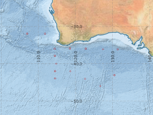
- There is no map for this survey.
Search for publications, reports and datasets from this and other voyages
Data publishing
This is a list of online datasets hosted by CSIRO. Other processed datasets hosted by collaborating organisations may be found on the 'Metadata' or "Reports, Publications and Maps' tab.
Use the Get data link on the right to extract data using the NCMI Data Trawler.
| Data Stream | Data Summary | Get data | ||||||||||
|---|---|---|---|---|---|---|---|---|---|---|---|---|
| Hydrology |
|
Get Data from Trawler |
Deployments by start time:- Click on column header to sort. Use link on 'Deployment' to see full details. Use the CSV button at the bottom to export data (tab delimited).
Search for deployments from this voyage and others
| Deployment | Operation | Station | Cast | Gear | Project | Start and end times | Start Location | End Location | Depth range | Max Depth | Description | |||
|---|---|---|---|---|---|---|---|---|---|---|---|---|---|---|
| Hydrology Cast [details] | 1 | 30 | 1961-02-20 03:30 | 1961-02-20 03:30 | -31.9167 | 107.0000 | 4392 | |||||||
| Hydrology Cast [details] | 1 | 30 | 1961-02-21 03:00 | 1961-02-21 03:00 | -31.9333 | 111.8000 | 4378 | |||||||
| Hydrology Cast [details] | 1 | 30 | 1961-02-26 08:00 | 1961-02-26 08:00 | -37.9000 | 114.4500 | 4024 | |||||||
| Hydrology Cast [details] | 1 | 30 | 1961-02-26 22:07 | 1961-02-26 22:07 | -40.0500 | 114.8333 | 3994 | |||||||
| Hydrology Cast [details] | 1 | 30 | 1961-02-27 12:00 | 1961-02-27 12:00 | -42.0167 | 114.5000 | 3821 | |||||||
| Hydrology Cast [details] | 1 | 30 | 1961-02-28 01:15 | 1961-02-28 01:15 | -43.9500 | 114.5000 | 3324 | |||||||
| Hydrology Cast [details] | 1 | 30 | 1961-03-01 01:00 | 1961-03-01 01:00 | -42.0167 | 118.6833 | 3950 | |||||||
| Hydrology Cast [details] | 1 | 30 | 1961-03-02 01:00 | 1961-03-02 01:00 | -44.0667 | 122.5667 | 3905 | |||||||
| Hydrology Cast [details] | 1 | 30 | 1961-03-03 00:00 | 1961-03-03 00:00 | -46.0000 | 126.6333 | 1803 | |||||||
| Hydrology Cast [details] | 1 | 30 | 1961-03-04 00:00 | 1961-03-04 00:00 | -43.0667 | 130.5000 | 4528 | |||||||
| Hydrology Cast [details] | 1 | 30 | 1961-03-05 15:00 | 1961-03-05 15:00 | -36.1333 | 131.3833 | 4762 | |||||||
| Hydrology Cast [details] | 1 | 30 | 1961-03-06 10:00 | 1961-03-06 10:00 | -36.0333 | 127.4167 | 4832 | |||||||
| Hydrology Cast [details] | 1 | 30 | 1961-03-07 09:00 | 1961-03-07 09:00 | -35.9500 | 122.7833 | 4385 | |||||||
| Hydrology Cast [details] | 1 | 30 | 1961-03-08 04:00 | 1961-03-08 04:00 | -35.8833 | 118.5167 | 3637 | |||||||
| Hydrology Cast [details] | 1 | 30 | 1961-03-09 00:00 | 1961-03-09 00:00 | -35.9667 | 114.4167 | 4630 | |||||||