Please login if you have access to particular applications.
Provider: All providers | |
Key Ecological Features | |
| Name: | Upwelling off Fraser Island - view region report showing all data |
| Region: | Temperate east |
| Area: | 12,768.24 km2 |
| Gear type: | ocean based acoustic current meter
|
| Layers used: |
CSIRO NCMI Acoustic Doppler Current Profiler data
- link to layer metadata NOAA drifting buoys (map) |
| Summary: | Records - 3568 Deepest: db |
| Last updated: | 28-Apr-2024 02:03. |
| Buffer: | |
Time series plot (1930 to present) - Y axis is ensembles per day per year
Region data
Show data list
| Year | Total inside region |
| 1989 | 51 |
| 1990 | 115 |
| 1991 | 8 |
| 1991 | 92 |
| 1992 | 54 |
| 1993 | 20 |
| 1994 | 1 |
| 1996 | 14 |
| 1997 | 2 |
| 1997 | 59 |
| 1998 | 225 |
| 1999 | 61 |
| 2000 | 7 |
| 2001 | 51 |
| 2002 | 2 |
| 2003 | 7 |
| 2003 | 26 |
| 2004 | 3 |
| 2004 | 70 |
| 2006 | 16 |
| 2007 | 3 |
| 2007 | 159 |
| 2008 | 21 |
| 2008 | 959 |
| 2009 | 3 |
| 2010 | 2 |
| 2012 | 453 |
| 2013 | 1173 |
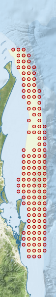
Region extents: 153° 11.8' E 27° 59.2' S to 153° 56.4' E 24° 29.9' S
Acknowledgements: Background map - Bright Earth e-Atlas Basemap v1.0 (AIMS, GBRMPA, JCU, DSITIA, GA, UCSD, NASA, OSM, ESRI) CC BY