Please login if you have access to particular applications.
Provider: All providers | |
Key Ecological Features | |
| Name: | Lord Howe seamount chain - view region report showing all data |
| Region: | Temperate east |
| Area: | 6,250.51 km2 |
| Gear type: | diver visual
|
| Layers used: |
Reef Life Survey (RLS) Sites (http://reeflifesurvey.com)
- link to layer metadata |
| Summary: | Records - 33 Deepest: db |
| Last updated: | 29-Apr-2024 13:11. |
| Buffer: | |
Time series plot (1930 to present) - Y axis is surveys per year
Region data
Show data list
| Year | Total inside region |
| 2013 | 33 |
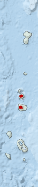
Region extents: 158° 16.0' E 32° 19.9' S to 159° 37.7' E 26° 33.4' S
Acknowledgements: Background map - Bright Earth e-Atlas Basemap v1.0 (AIMS, GBRMPA, JCU, DSITIA, GA, UCSD, NASA, OSM, ESRI) CC BY