Please login if you have access to particular applications.
Provider: All providers | |
Key Ecological Features | |
| Name: | Canyons on the eastern continental slope - view region report showing all data |
| Region: | Temperate east |
| Area: | 5,871.03 km2 |
| Gear type: | satellite tag
|
| Layers used: |
aatams sattag dm location map - link to layer metadata New Zealand Fur Seal CTD Profiles - link to layer metadata Australian Fur Seal CTD Profiles - link to layer metadata aatams sattag dm profile map - link to layer metadata aatams sattag dm dive profile map - link to layer metadata |
| Summary: | Records - 130 Deepest: db |
| Last updated: | 20-Oct-2025 15:24. |
| Buffer: | |
Time series plot (1930 to present) - Y axis is dive locations or haulout sites per year
Region data
Show data list
| Year | Total inside region |
| 2012 | 40 |
| 2013 | 90 |
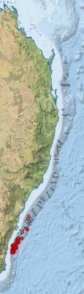
Region extents: 150° 24.4' E 36° 32.6' S to 154° 23.0' E 24° 41.6' S
Acknowledgements: Background map - Bright Earth e-Atlas Basemap v1.0 (AIMS, GBRMPA, JCU, DSITIA, GA, UCSD, NASA, OSM, ESRI) CC BY