Please login if you have access to particular applications.
Provider: All providers | |
Australian Marine Parks | |
| Name: | Great Australian Bight Special Purpose Zone (IUCN VI) - view region report showing all data |
| Region: | South-west |
| Comments: | This part of the reserve was formerly known as the Great Australian Bight Marine Park (Commonwealth Waters). Transitional management arrangements apply until the South-west CMR Network Management Plan comes into effect. Australia's network of Australian Marine Parks (revised 2014-03-28) http://www.environment.gov.au/fed/catalog/search/resource/details.page?uuid=%7B2E8DD19C-1B93-4D90-BD1C-128DDC4A2998%7D |
| Area: | 3,861.46 km2 |
| Gear type: | ocean based acoustic current meter
 |
| Layers used: |
CSIRO NCMI Acoustic Doppler Current Profiler data - link to layer metadata NOAA drifting buoys (map) |
| Summary: | Records - 130 Deepest: db |
| Last updated: | 17-Sep-2025 18:04. |
| Buffer: | |
Time series plot (1930 to present) - Y axis is ensembles per day per year
Region data
Show data list
| Year | Total inside region |
| 2000 | 130 |
| 2004 | 5 |
| 2007 | 3 |
| 2009 | 2 |
| 2011 | 3 |
| 2012 | 9 |
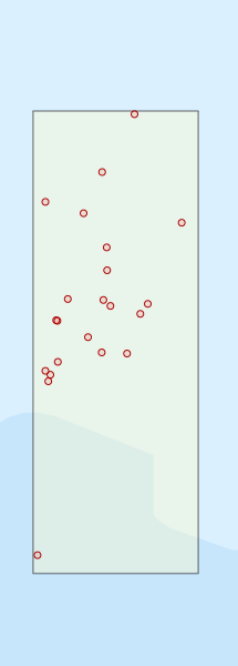
Region extents: 130° 28.0' E 33° 24.0' S to 130° 52.0' E 32° 28.0' S
Acknowledgements: Background map - Bright Earth e-Atlas Basemap v1.0 (AIMS, GBRMPA, JCU, DSITIA, GA, UCSD, NASA, OSM, ESRI) CC BY