
|
|
Online SST Service: More InformationMarine and Atmospheric Research Remote Sensing Facility |

|

|

|

|

|

|

|
Your own password protected web-page, from which you can view and download the most recent Sea Surface Temperature images of your chosen region of interest.
| >> Description of these three options. > Description of these three options. Description of these three options. |
|
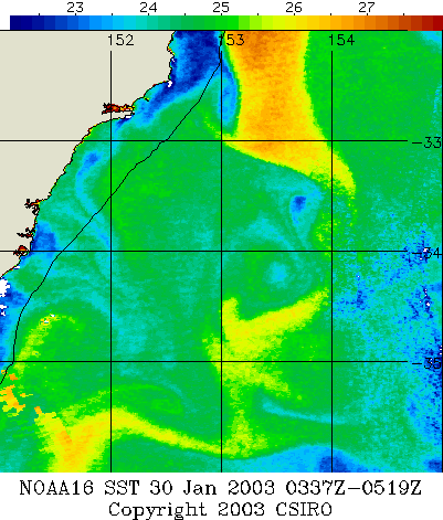
example of Sea Surface Temperature (SST) Imagery, produced from NOAA Satellite Data which was received at our Remote Sensing Facility in Hobart, Tasmania. |
| Sea Surface Temperature |
|
You get your own web page of custom prepared SST images. The images there are tailored to meet your needs with respect to scaling and region shown. A special page is provided from which you can change your service settings: region, temperature and so on. Up to four times each day, new images are uploaded to the web pages and images for the last seven days are available at any time. Detailed cloud cover estimates and quick-view thumbnail images are also provided.
Access your page at any time by using your username and password. There is no limit on the number of images you can download. The cost of your service is not based on the number of times you access it, or the size or number of downloads. It is based on the length of time you sign up for.
|
Enhanced service
,
with SST Image-Viewer software |
$1,300.00 per quarter
$120.00 per week |
| Standard service |
$1,128.40 per quarter
$108.50 per week |
Our normal billing period is quarterly, you may opt for any period you desire.
email: marine-remote-sensing@csiro.au
phone: DMR Remote Sensing on (03) 6232 5398
View a Sample Service
Note: Password protection has been disabled for this page. Your service will prompt you for a user-name and password.
Colour is used in the images to describe surface temperature. A scale bar shows the relationship between colour and temperature. SST values are usually accurate to one degree provided that clouds are not in the near vicinity. Geographic information such as; land mask, coastline, state borders, 200m depth contour and latitude-longitude grid are superimposed on the images.
The availability and usefulness of images depends on clear skies as the NOAA satellite's AVHRR satellite sensors are not able obtain surface data from beneath clouds. Contamination by cloud is shown by: white areas over the sea, warmer narrow strips at cloud edges and less obviously by reduced values (caused by thin cloud and sea fog). Occasionally, on clear calm sunny days, abnormally high temperatures will appear because of skin warming. This will disappear in the night time images.
Click here to learn more about how the facility process and apply satellite-derived estimates of sea surface temperature.
For more information contact
![]()
Use of this web site and information available from it is subject to our
Legal Notice and Disclaimer