THE IMPACT OF URBAN DEVELOPMENT
|
|||||||||||||||||||||||||||||||||||||||||||||||||||||||||||||||||||||||||||||||||||||||||||||||||||||||||||||||||||||
|
Scenario |
Transport |
Population |
Employment |
||
|
Changes |
% change public |
Ring |
% of added |
||
|
Base City 1991 |
(20) |
Inner |
(7) |
(22/53/32) |
|
|
Middle |
(58) |
(55/36/47) |
|||
|
Outer |
(35) |
(23/11/20) |
|||
|
Businessas Usual 2011 |
Increased density, congestion |
19 |
Inner |
7 |
22/53/32 |
|
Middle |
58 |
55/36/47 |
|||
|
Outer |
35 |
23/11/20 |
|||
|
Corridor City 2011 |
Radial roads, rail better |
32 |
Inner |
0 |
0/0/0 |
|
Middle |
0 |
0/0/0 |
|||
|
Outer |
100 |
100/100/100 |
|||
|
Compact City 2011 |
Improved public transport |
30 |
Inner |
100 |
0/100/0 |
|
Middle |
0 |
33/0/0 |
|||
|
Outer |
0 |
67/0/0 |
|||
|
Edge City 2011 |
Freeway ring road, radial rail |
16 |
Inner |
0 |
0/0/0 |
|
Middle |
86 |
33/83/83 |
|||
|
Outer |
14 |
67/17/17 |
|||
|
Fringe City 2011 |
Upgrade to radial rail, road links |
28 |
Inner |
0 |
0/0/0 |
|
Middle |
10 |
10/10/10 |
|||
|
Outer |
60 |
60/60/60 |
|||
|
Fringe |
30 |
30/30/30 |
|||
|
Ultra City 2011 |
Freeways, fast rail links |
31 |
Inner |
2 |
7/16/10 |
|
Middle |
17 |
17/11/14 |
|||
|
Outer |
11 |
7/3/6 |
|||
|
Regional |
70 |
70/70/70 |
|||
‡ Manufacture/Producer Services/Social Services
In the business as usual scenario, the new half million population is distributed across the 26 zones in the Melbourne metropolitan area in proportion to the 1991 base, as shown in Table 2.
|
Zone |
Land area |
Residential population |
Density |
|
Inner Melbourne |
81.7 |
227.4 |
27.8 |
|
Middle Melbourne |
1041.1 |
1831.8 |
17.4 |
|
Outer Melbourne |
6708.5 |
1109.1 |
1.7 |
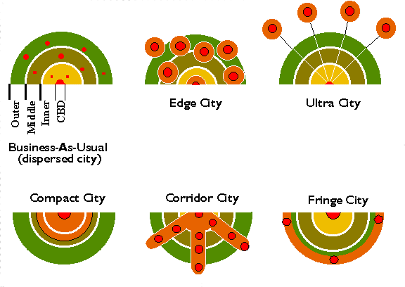
This essentially continues a dispersed pattern of constrained development with population increased proportionately in each ring shown in Figure 1. There is a significant amount of land which remains available for residential or commercial development on outer the fringes of Melbourne. Consolidation trends associated with dual occupancy and infill development would have some limited influence. As such, this scenario models many of the current trends operating in Melbourne, including a slight increase in density.
In this scenario, the new population is distributed to the eight statistical local areas that comprise inner Melbourne. The density of new residential development or redevelopment in these zones is 300 persons/ha — well above business as usual levels for the inner city. The effects of an expected increase in the use of ‘slow’modes of transport (walking, cycling) was not considered.
New population is allocated to six major district centres within Melbourne connected via a major ring road. The district centres are located in zones situated within or close to the middle ring of Melbourne, as shown in Figure 1.
A proposed ring road is the same as for the base case except that, in this scenario, improvements have been made in order to bring it to freeway status. The six nodes are also on radial rail networks centred on the CBD. These edge city zones are assigned medium density housing up to 80 persons/ha.
In this scenario, the new population is added to three corridor zones in the outer ring of the city. The three corridors receive transport infrastructure upgrades (of a radial nature) to both road and rail.
Here, 30% of new population is added to three development corridors in new green-field sites on the urban fringe. Of the remaining 70%, 10% is added to the middle ring of zones, 60% is added to the outer ring.
New manufacturing and service industries are also distributed to these same zones and in the same proportions, providing a balance between new homes and new jobs. The times of development of new homes and jobs will also be similar, increasing the opportunities for selection of a home and job in the same local area, thereby increasing self-containment of commuting, as well as of shopping, and other trips.
The new corridor development and distribution to existing middle and outer zones is another variation of present and recent trends, except that there is no addition to the inner city zones.
The new corridor fringe development is connected to the rest of the city with radial freeway/arterial links and with upgraded heavy rail links, thereby reducing travel times to these zones.
In this scenario, 70% of the new population is added to four provincial centres within a 100 km radius of Melbourne (Ballarat, Bendigo, Seymour, Warragul); the remaining 30% is dispersed throughout the 26 zones in proportion to the base-year distributions. Summarised in Table 1, it is almost business as usual, but represents a 21st century solution to the late-20th century problem of the future viability of many of Australia’s provincial cities. These centres are struggling to find a new economic base, yet they represent environments of high residential amenity and liveability much sought after by sections of the capital city’s population. The proposed solution (scenario) involves linking (selected) provincial centres with their capital city via high-speed rail, thereby making them part of the functional urban region of that city (functional urban being defined by patterns of daily commuting to work). In the scenario modelled, the four provincial centres are linked by fast train (150 km/h) and freeway to the centre of Melbourne.
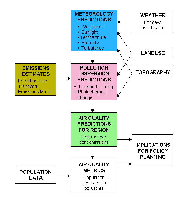
Within the stated limitations and assumptions associated with the landuse-transport-air quality modelling, we can advance the following conclusions related to air quality and urban form:
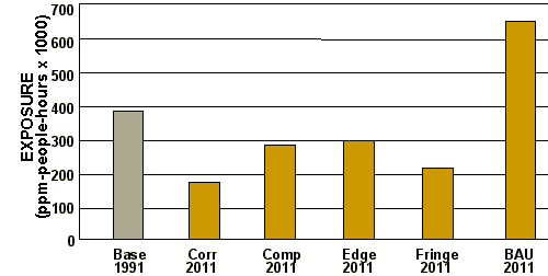
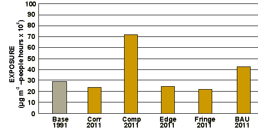
When supported by the simultaneous installation or upgrading of appropriate transport infrastructure, any one of several strategies designed to deliberately channel and concentrate additional population and industry into specific ‘zones’ within a large city such as Melbourne will deliver environmental and efficiency benefits that consistently outperform those associated with a ‘business as usual’ approach. In the case of photochemical smog, for example, a corridor model for Melbourne’s metropolitan development in 2011 on a summer day of adverse meteorological conditions delivers a 55% improvement over the base situation on the same day for that city in 1991. Where new development is primarily concentrated at nodes on the fringe, within the inner suburbs or at key nodes within the city, the air quality enhancements are also significant (respectively, 39, 24 and 21% reduction in population exposure to smog compared to the base case for the same adverse summer meteorological conditions). For business as usual development, the result is an increase by 71% in the population exposure to smog at levels above those considered appropriate by present air quality standards (see Figure 4). No analysis was made for the ultra city model but it is expected to be similar to or better than the fringe city.
In this study we set PM10 population-based emissions in winter to be equivalent to a summer week day in 1991, to reflect the expectation that domestic heating using solid fuels (the biggest cause of adverse winter particle pollution: EPAV, 1997) is likely to be severely controlled in the future. For the compact city scenario in winter the result is that PM10 emissions are little changed from the 1991 summer base model. However, since all the population increase proposed for Melbourne in this scenario is to be accommodated in the inner suburbs, more people will be exposed to the ‘umbrella’ of particle emissions. Hence the considerably higher levels of population exposure represented in Figure 5 on a winter day of adverse meteorological conditions for the compact city.
Indeed, on the modelled day of adverse meteorological conditions in 2011, the compact city delivers a 160% increase in population exposure to particle emissions compared to the Melbourne base case (1991). For business as usual development, the level of increased population exposure is 61%. Edge, corridor and fringe developments all deliver improvements as far as population exposure to PM10 particles is concerned. (The ultra city was not modelled but it is expected to give similar benefits to the fringe city.)
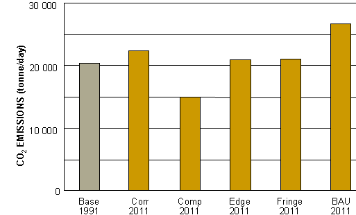
Here we focus on vehicle emissions for reducing CO2 from urban areas. Figure 6 illustrates that a compact city form delivers the lowest output of CO2 emissions, due to greater use of public transport and fewer vehicle hours (and kilometres) travelled compared to other forms of urban development. A shift by 2011 from business as usual urban development to a compact city form may give savings in CO2 emissions of the order of 11,500 tonnes each day — a 43% saving. Development of an ultra city would lead to a similar result to that shown for the corridor city — a 16% saving.
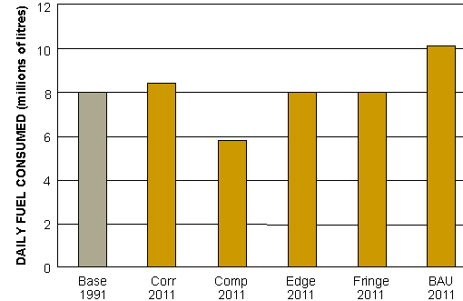
As one might expect from the results on CO2 emissions, the compact city emerges as the most fuel efficient of all urban forms (see Figure 7) with 43% less fuel consumption than a business as usual form of development. The fact that in the corridor city scenario infrastructure investment was primarily radial in nature is the reason why higher levels of daily travel were generated than in other scenarios (i.e. limited prospects for cross-town trips). The addition of a higher-grade ring or orbital transport network to the current corridor city infrastructure, however, could be expected to generate positive benefits in travel time and energy consumption outcomes.
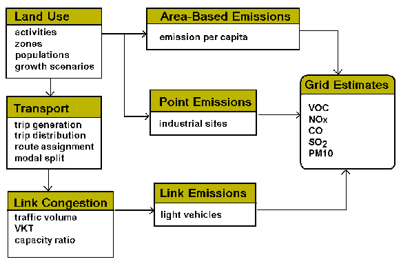
It is just this type of strategic planning and evaluation that is needed to chart the future infrastructure investments required for major metropolitan areas into the 21st century. In the United States, for example, the federal Clean Air Act is requiring a closer linking of funding in areas such as urban transport with a set of goals. These goals include air quality. Integrated landuse-transport-environment models provide the means by which impacts of proposed urban development can be evaluated across the spectrum of dimensions relevant to the key goals of economic efficiency, environmental sustainability and social equity.
5. Conclusion
Urban form does matter — and not just for urban air quality. In relation to indicators such as greenhouse gases and energy consumption, there appears to be universal concurrence from the landuse-transport-environment modelling that to maintain a business as usual model of urban development (viz, relatively laissez faire, low density, dispersed) is to condemn the population and industry of that city to a sub-optimal living and working environment into the future.
On most of the measures considered here, a trend to a compact city will lead to the greatest improvement compared with business as usual. However there is a sign that the situation is more complex: higher population density leads to higher concentrations of health-impairing fine particles, a factor of concern in winter in particular (Figure 5). Perhaps in the scenarios studied here this is just a consequence of the urban density not being high enough! But it is here that the social acceptability of different living arrangements enters into the debate. And it is one which is not readily resolved.
Acknowledgements
To Kevin Gu, Catherine Wilson, and Peter Newman for their help, facilitation and insights.
References
Brotchie, J.F., Dickey, J.W. and Sharpe, R. 1980, ‘TOPAZ planning technique and applications’, Lecture Notes in Economics and Mathematical Systems Series, 180, Springer–Verlag, Berlin.
Cope, M. 1997, ‘Mathematical modelling of photochemical smog in the Port Phillip Control Region’, PhD Thesis, Department of Earth Sciences, Melbourne University, May.
EPAV 1997, ‘Taking Stock, A background paper for the Port Phillip region air quality management plan’, Publication 535, Environment Protection Authority of Victoria
Gipps, P.G. et al. 1997, ‘Journey to Work, Employment and the Changing Structure of Australian Cities’, Australian Housing and Urban Research Institute,, Melbourne.
McRae, G.J., Goodin, W.R. and Seinfeld, J.H. 1992, ‘CIT Photochemical Airshed Model — Users Manual, Carnegie Mellon University, Pittsburg, PA, and California Institute of Technology, Pasadena, CA.
Manins, P.C. 1995, ‘Regional air pollution modelling for planners’, Terrestrial, Atmospheric & Oceanic Sciences, 6(3), 393–401.
Minnery, J.R. 1992. ‘Urban Form and Development Strategies: Equity, Environmental and Economic Implications’, The National Housing Strategy Background Paper 7, AGPS, Canberra.
NEPC 1997, ‘Draft National Environment Protection Measure and Impact Statement for Ambient Air Quality’, National Environment Protection Council Service Corporation, Adelaide, November.
Newton, P.W. (ed.) 1997. ‘Re-Shaping Cities for a More Sustainable Future’, Research Monograph 7, Australian Housing and Urban Research Institute, Melbourne.
Physick, W.L. and Manins, P.C. 1994, ‘Application of the air quality model LADM for regional planning purposes’, in J.M. Baldasano et al. (eds), Air Pollution II: Proc. 2nd Int. Conf. On Air Pollution, Barcelona, Spain, 1994, Computational Mechanics Publications, Southampton, pp 27–34.
Pressman, N. 1985. ‘Forces for spatial change’, in J.F. Brotchie et al. (eds), The Future of Urban Form, Croom Helm, London, pp 94–111.
![]()

Modified: April 3, 2008