Voyage details and related metadata, reports, events and data.
SS2012_T03
- is a Marine National Facility ![]() voyage
voyage
Period: 2012-06-06 22:00 to 2012-06-17 20:00 UTC
Duration: 10.92 days
From: Lautoka To: Hobart
Region: Pacfic, Tasman Sea
Ship: Southern Surveyor [details]
Description: MNF Southern Surveyor RV ss2012_t03. Predicting the sources, distribution and fate of floating marine debris. Scientific Objectives: Marine debris has become a major hazard to marine life through ingestion and entanglement and is also leading to aesthetic degradation, economic losses and human health hazards. The increase in amounts of marine debris can be attributed to at least three factors: (1) plastics replaced natural fibers in the manufacture of many everyday items; (2) plastics are often less expensive than the materials they replace,thereby decreasing incentives to reuse or recycle items; (3) there are simply more ships and coastal residents that can lose or discard materials. Monitoring studies are needed to assess the effectiveness of governments' actions in reducing the overall amount of marine debris as well as certain types of debris of particular concern, such as fishing gear and microplastics. For the first time, floating marine debris (FMD) will be systematically sampled in oceanic waters close to east coast of Australia. This voyage will provide us the opportunity to collect samples over a broad range of latitudes. These data will be useful to test a hypothesis recently proposed by marine researchers: FMD concentrations tend to be higher at subtropical latitudes. The general aim of this project is to estimate FMD composition and concentration (pieces/km2) at different locations around Australia. (Extract from the voyage plan, please see plan for full details.)
Leader: Julia Reisser (CMAR & UWA)
Project: Unknown (no details available) [details]
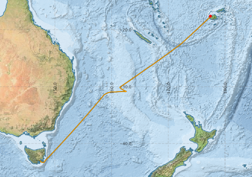
Voyage extents: 43° 18.5' S to 17° 36.0' S 147° 20.3' E to 177° 26.4' E Get voyage track shapefile Get CSV
Marlin Metadata:-
Participants - on ship:-
| Name | Role | Organisation |
|---|---|---|
| Brett Muir | MNF Electronics Support | CSIRO Marine and Atmospheric Research |
| Chris Wilcox | Marine Plastics Project | CSIRO Oceans & Atmosphere - Hobart |
| Dagmar Kubistin | Greenhouse gases study | University of Wollongong |
| Julia Reisser | Chief Scientist - Marine debris study | CMAR/UWA Facility |
| Luana Lins | Benthic Isopods Study | University of Sydney |
| Pamela Brodie | MNF Computing support | CSIRO Oceans & Atmosphere - Hobart |
| Stephen McCullum | MNF Voyage Manager | CSIRO Marine and Atmospheric Research |
This list includes those that may have only been on part of the voyage. See voyage reports on 'Reports and Maps' tab for details.
Marine National Facility Reports - plans, summaries and data processing
-
SS2012_T03 Voyage Plan
- includes objectives, investigator details, proposed data collection, voyage track and equipment to be used.
-
SS2012_T03 Underway Data Processing Report
- details of data processing steps, calibration information, instruments used and any issues with the data.
-
SS2012_T03 Voyage Summary
- includes preliminary results, voyage narrative, types of data collected with C77/ROSCOP codes.
-
SS2012_T03 Scientific Highlight
- report of the key outputs
-

Publications, reports and datasets from this voyage.
Dataset
- Bakker, Dorothee C E; Pfeil, Benjamin; Smith, Karl; Hankin, Steven; Olsen, Are; Alin, Simone R; Cosca, Catherine E; Harasawa, Sumiko; Kozyr, Alexander; Nojiri, Yukihiro; O'Brien, Kevin M; Schuster, Ute; Telszewski, Maciej; Tilbrook, Bronte; Wada, Chisato; Akl, John; Barbero, Leticia; Bates, Nicolas R; Boutin, Jacqueline; Bozec, Yann; Cai, Wei-Jun; Castle, Robert D; Chavez, Francisco P; Chen, Lei; Chierici, Melissa; Currie, Kim I; de Baar, Hein J W; Evans, Wiley; Feely, Richard A; Fransson, Agneta; Gao, Zhongyong; Hales, Burke; Hardman-Mountford, Nicolas J; Hoppema, Mario; Huang, Wei-Jen; Hunt, Christopher W; Huss, Betty; Ichikawa, Tadafumi; Johannessen, Truls; Jones, Elizabeth M; Jones, Steve D; Jutterstrøm, Sara; Kitidis, Vassilis; Körtzinger, Arne; Landschützer, Peter; Lauvset, Siv K; Lefèvre, Nathalie; Manke, Ansley; Mathis, Jeremy T; Merlivat, Liliane; Metzl, Nicolas; Murata, Akihiko; Newberger, Timothy; Omar, Abdirahman M; Ono, Tsuneo; Park, Geun-Ha; Paterson, Kristina; Pierrot, Denis; Ríos, Aida F; Sabine, Christopher L; Saito, Shu; Salisbury, Joe; Sarma, Vedula V S S; Schlitzer, Reiner; Sieger, Rainer; Skjelvan, Ingunn; Steinhoff, Tobias; Sullivan, Kevin; Sun, Heng; Sutton, Adrienne; Suzuki, Toru; Sweeney, Colm; Takahashi, Taro; Tjiputra, Jerry; Tsurushima, Nobuo; van Heuven, Steven; Vandemark, Doug; Vlahos, Penny; Wallace, Douglas WR; Wanninkhof, Rik; Watson, Andrew J (2014): Surface Ocean CO2 Atlas (SOCAT) V2. PANGAEA, 10.1594/PANGAEA.811776
Journal Article
- Bukosa, Beata,Deutscher, Nicholas M.,Fisher, Jenny A.,Kubistin, Dagmar,Paton-Walsh, Clare,Griffith, David W. T. (2019) Simultaneous shipborne measurements of CO2, CH4 and CO and their application to improving greenhouse-gas flux estimates in Australia. Atmospheric Chemistry and Physics 19 pp7055-7072. 10.5194/acp-19-7055-2019
- Reisser, Julia,Shaw, Jeremy,Wilcox, Chris,Hardesty, Britta Denise,Proietti, Maira,Thums, Michele,Pattiaratchi, Charitha,Hays, Graeme Clive (2013) Marine Plastic Pollution in Waters around Australia: Characteristics, Concentrations, and Pathways. PLoS ONE 8 ppe80466-. 10.1371/journal.pone.0080466
Search for publications, reports and datasets from this and other voyages
Data publishing
This is a list of online datasets hosted by CSIRO. Other processed datasets hosted by collaborating organisations may be found on the 'Metadata' or "Reports, Publications and Maps' tab.
Use the Get data link on the right to extract data using the NCMI Data Trawler.
| Data Stream | Data Summary | Get data | ||||||||||||||
|---|---|---|---|---|---|---|---|---|---|---|---|---|---|---|---|---|
| ADCP Data |
|
Get Data from Trawler Download NetCDFss2012_t03_ADCP_long_nc.zip Download NetCDFss2012_t03_ADCP_short_nc.zip Overview ADCP Dataset HTML Download Processing Report ss2012_t03ADCP.pdf |
||||||||||||||
| Multibeam echosounder |
|
Get Data from Trawler |
||||||||||||||
| pCO2 |
|
External link - download datafile at IMOS |
||||||||||||||
| SOOP Bio-acoustics |
|
External link - datafile at IMOS NetCDF Data Format: Manual Download |
||||||||||||||
| Underway |
|
Get Data from Trawler Download 5 sec NetCDF dataset ss2012_t03UWYnc.zip |
Deployments by start time:- Click on column header to sort. Use link on 'Deployment' to see full details. Use the CSV button at the bottom to export data (tab delimited).
Search for deployments from this voyage and others
| Deployment | Operation | Station | Cast | Gear | Project | Start and end times | Start Location | End Location | Depth | Description | |||
|---|---|---|---|---|---|---|---|---|---|---|---|---|---|
| Underway System [details] | Air Temperature Sensor-HMT333,Barometer,Doppler speed log,Fluorometer WS3S-443P,Gill Ultrasonic Wind Sensor,Gill Ultrasonic Wind Sensor,Humidity Sensor-HMT333,IMOS Port Pyranometer-SN 35122F3,IMOS Port Radiometer-SN 35111F3,IMOS Stbd Pyranometer-SN 35123F3,IMOS Stbd Radiometer-SN 35093F3,IMOS rain gauge,IMOS rain gauge,Licor-UWQ 3708,RM Young 05106 wind monitor-75621,RM Young 05106 wind monitor-75621,RM Young 05106 wind monitor-75621,RM Young Rain Gauge,Remote Temperature (T)-SN 2621,Seapath 200,Seapath 200,Seapath 200,Simrad EK60 echosounder,ThermoSalinoGraph (TSG)-SS-SN 1777 | 500 | 2012-06-06 22:03 | 2012-06-17 21:06 | -17.6031 | 177.4391 | -42.8863 | 147.3386 | |||||
| Multibeam echosounder [details] | EM300 Multibeam Echosounder | 2012-06-06 22:38 | 2012-06-17 20:57 | -17.6294 | 177.3775 | -42.8855 | 147.3386 | 5786.9 | |||||
| ADCP Data [details] | RDI Ocean Surveyor Acoustic Doppler current profiler | 500 | 2012-06-07 21:11 | 2012-06-18 16:04 | -17.6016 | 177.4394 | -43.1805 | 147.5362 | 589.5 | ||||