Voyage details and related metadata, reports, events and data.
SS2011_V01
- is a Marine National Facility ![]() voyage
voyage
Period: 2011-04-16 06:00 to 2011-04-21 22:00 UTC
Duration: 5.67 days
From: Hobart To: Hobart
Region: Southern Ocean-Indian sector. Subantarctic Zone southwest of Tasmania
Ship: Southern Surveyor [details]
Description: Southern Surveyor Research Voyage SS2011_v01. Integrated Marine Observing System (IMOS) Facility 3. Southern Ocean Time Series (SOTS) moorings for climate and carbon cycle studies south-west of Tasmania(47°S, hundred and 40°E). The overall scientific objective is to obtain frequent measurements of surface and deep ocean properties that control the transfer of CO2 from the atmosphere to the upper ocean, and then onwards to the ocean interior in the form of sinking particles. This "biological pump" drives carbon sequestration from the atmosphere, and writes the sedimentary record. The controls on its intensity are complex and involve processes that vary on daily, weekly, seasonal, and interannual timescales. Obtaining observations with the necessary frequency is not possible from ships. For this reason the NCRIS IMOS Southern Ocean Time Series Facility seeks to obtain this information using automated sensor measurements and sample collections. This voyage will recover the Southern Ocean Flux Station (SOFS-1) mooring to obtain in-air and in-sea measurements to better understand the exchange of heat, moisture, and gases between the ocean and atmosphere. It will also recover the Pulse-7 mooring that has been making measurements of temperature, salinity, mixed layer depth, photosynthetically available radiation, oxygen, total dissolved gases, and phytoplankton fluorescence and backscatter. The Pulse-7 mooring also collects 24 paired water samples, approximately weekly, for later measurement of dissolved nitrate, silicate, inorganic carbon, and total alkalinity.
Leader: E. Schulz (BOM)
Project: SOTS: Southern Ocean Time Series automated moorings for climate and carbon cycle studies southwest of Tasmania [details]
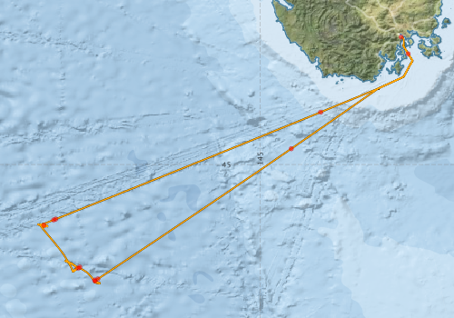
Voyage extents: 46° 58.3' S to 42° 53.1' S 141° 18.5' E to 147° 31.8' E Get voyage track shapefile Get CSV
Marlin Metadata:-
Participants - on ship:-
| Name | Role | Organisation |
|---|---|---|
| Andrew Tabor | Moorings ? deck lead | CSIRO Oceans & Atmosphere - Hobart |
| Dave Cherry | Moorings | CSIRO Oceans & Atmosphere - Hobart |
| Eric Schulz | Chief Investigator | Bureau of Meteorology |
| Hugh Barker | MNF Computing Support | CSIRO Oceans & Atmosphere - Hobart |
| Karl Forcey | MNF Electronics Support | CSIRO Oceans & Atmosphere - Hobart |
| Lindsay Pender | MNF Voyage Manager | CSIRO Oceans & Atmosphere - Hobart |
| Paul Durack | Camera/filming for BBC | CSIRO Oceans & Atmosphere - Hobart |
| Peter Jansen | Moorings and CTD | CSIRO Oceans & Atmosphere - Hobart |
| Rob Sherrington | Moorings | CSIRO Oceans & Atmosphere - Hobart |
| Rod Palmer | MNF Electronics Support | CSIRO Oceans & Atmosphere - Hobart |
| Tara Martin | MNF Swath Mapping | CSIRO Oceans & Atmosphere - Hobart |
This list includes those that may have only been on part of the voyage. See voyage reports on 'Reports and Maps' tab for details.
Marine National Facility Reports - plans, summaries and data processing
-
SS2011_V01 Voyage Plan
- includes objectives, investigator details, proposed data collection, voyage track and equipment to be used.
-
SS2011_V01 Scientific Highlight
- report of the key outputs
-
SS2011_V01_VOYAGE Voyage Plan
- includes objectives, investigator details, proposed data collection, voyage track and equipment to be used.
-
SS2011_V01 Underway Data Processing Report
- details of data processing steps, calibration information, instruments used and any issues with the data.
-
SS2011_V01 Voyage Summary
- includes preliminary results, voyage narrative, types of data collected with C77/ROSCOP codes.
-

Publications, reports and datasets from this voyage.
Dataset
- Bakker, Dorothee C E; Pfeil, Benjamin; Smith, Karl; Hankin, Steven; Olsen, Are; Alin, Simone R; Cosca, Catherine E; Harasawa, Sumiko; Kozyr, Alexander; Nojiri, Yukihiro; O'Brien, Kevin M; Schuster, Ute; Telszewski, Maciej; Tilbrook, Bronte; Wada, Chisato; Akl, John; Barbero, Leticia; Bates, Nicolas R; Boutin, Jacqueline; Bozec, Yann; Cai, Wei-Jun; Castle, Robert D; Chavez, Francisco P; Chen, Lei; Chierici, Melissa; Currie, Kim I; de Baar, Hein J W; Evans, Wiley; Feely, Richard A; Fransson, Agneta; Gao, Zhongyong; Hales, Burke; Hardman-Mountford, Nicolas J; Hoppema, Mario; Huang, Wei-Jen; Hunt, Christopher W; Huss, Betty; Ichikawa, Tadafumi; Johannessen, Truls; Jones, Elizabeth M; Jones, Steve D; Jutterstrøm, Sara; Kitidis, Vassilis; Körtzinger, Arne; Landschützer, Peter; Lauvset, Siv K; Lefèvre, Nathalie; Manke, Ansley; Mathis, Jeremy T; Merlivat, Liliane; Metzl, Nicolas; Murata, Akihiko; Newberger, Timothy; Omar, Abdirahman M; Ono, Tsuneo; Park, Geun-Ha; Paterson, Kristina; Pierrot, Denis; Ríos, Aida F; Sabine, Christopher L; Saito, Shu; Salisbury, Joe; Sarma, Vedula V S S; Schlitzer, Reiner; Sieger, Rainer; Skjelvan, Ingunn; Steinhoff, Tobias; Sullivan, Kevin; Sun, Heng; Sutton, Adrienne; Suzuki, Toru; Sweeney, Colm; Takahashi, Taro; Tjiputra, Jerry; Tsurushima, Nobuo; van Heuven, Steven; Vandemark, Doug; Vlahos, Penny; Wallace, Douglas WR; Wanninkhof, Rik; Watson, Andrew J (2014): Surface Ocean CO2 Atlas (SOCAT) V2. PANGAEA, 10.1594/PANGAEA.811776
Journal Article
- Eriksen, R., Trull, TW., Davies, D., Jansen, P., Davidson, A T., Westwood, K., van den Enden, R. (2018) 'Seasonal succession of phytoplankton community structure from autonomous sampling at the Australian Southern Ocean Time Series (SOTS) observatory', Marine Ecology Progress Series 589 pp 13-31. 10.3354/meps12420
- Schlitzer, Reiner,Anderson, Robert F.,Dodas, Elena Masferrer,Lohan, Maeve,Geibert, Walter,Tagliabue, Alessandro,Bowie, Andrew,Jeandel, Catherine,Maldonado, Maria T.,Landing, William M. (2018) The GEOTRACES Intermediate Data Product 2017. Chemical Geology 493 pp210-223. 10.1016/j.chemgeo.2018.05.040
Search for publications, reports and datasets from this and other voyages
Data publishing
This is a list of online datasets hosted by CSIRO. Other processed datasets hosted by collaborating organisations may be found on the 'Metadata' or "Reports, Publications and Maps' tab.
Use the Get data link on the right to extract data using the NCMI Data Trawler.
| Data Stream | Data Summary | Get data | ||||||||||||
|---|---|---|---|---|---|---|---|---|---|---|---|---|---|---|
| CTD profile |
|
Get Data from Trawler Download CTD Plots ss2011_v01_CTD_Plotspdf.zip Download NetCDF data ss2011_v01CTDnc.zip Processing report: ss2011_v01ctd.pdf |
||||||||||||
| Multibeam echosounder |
|
Get Data from Trawler |
||||||||||||
| pCO2 |
|
External link - download datafile at IMOS |
||||||||||||
| SOOP Bio-acoustics |
|
External link
Transect 2 - datafile at IMOS NetCDF Data Format: Manual Download |
||||||||||||
| Underway |
|
Get Data from Trawler Download 5 sec NetCDF dataset ss2011_v01UWYnc.zip |
||||||||||||
| XBT Profile |
|
Get Data from Trawler Download xbt_ascii_ma_2007_2012.zip (MEDS ASCII format ) Download xbt_nc_ss2007_2012.zip (NetCDF format) |
Search for events from this voyage and others
Events ordered by start time:- Click on column header to sort. Use link on 'When' to see full details. Use the CSV button at the bottom to export data.
| When (UTC) | Latitude | Longitude | Instrument | Identifier | Action | Log | Subject / Comments |
|---|---|---|---|---|---|---|---|
| 2011-04-19 01:35 [view ] | -46.7000 | 142.0100 | Argo float [view] | 6981 | deploy | Owner: Tom Trull FLBB CTD Type: SBE-41 CP IDO Serial number: 3028 | |
| 2011-04-19 02:08 [view ] | -46.7200 | 141.9800 | Argo float [view] | 6980 | deploy | Owner: Tom Trull FLBB CTD Type: SBE-41 CP IDO Serial number: 3027 |
Deployments by start time:- Click on column header to sort. Use link on 'Deployment' to see full details. Use the CSV button at the bottom to export data (tab delimited).
Search for deployments from this voyage and others
| Deployment | Operation | Station | Cast | Gear | Project | Start and end times | Start Location | End Location | Depth | Description | |||
|---|---|---|---|---|---|---|---|---|---|---|---|---|---|
| Underway System [details] | Air Temperature Sensor-HMT333,Barometer,Doppler speed log,Fluorometer WS3S-1203,Gill Ultrasonic Wind Sensor,Gill Ultrasonic Wind Sensor,Humidity Sensor-HMT333,IMOS Port Pyranometer-SN 35122F3,IMOS Port Radiometer-SN 35111F3,IMOS Stbd Pyranometer-SN 35123F3,IMOS Stbd Radiometer-SN 35093F3,IMOS rain gauge,IMOS rain gauge,Licor-UWQ 3708,RM Young 05106 wind monitor-75621,RM Young 05106 wind monitor-75621,RM Young 05106 wind monitor-75621,RM Young Rain Gauge,Remote Temperature (T)-SN 2621,Seapath 200,Seapath 200,Seapath 200,Simrad EK60 echosounder,ThermoSalinoGraph (TSG)-SS-SN 1777 | 2365 | 2011-04-16 05:56 | 2011-04-21 20:53 | -42.8863 | 147.3385 | -43.0036 | 147.3767 | |||||
| Multibeam echosounder [details] | EM300 Multibeam Echosounder | 2011-04-16 08:13 | 2011-04-21 17:41 | -43.1660 | 147.4549 | -43.3455 | 147.4881 | 5624.3 | |||||
| XBT Cast [details] | Sippican Deep Blue | 2391 | 2011-04-17 00:16 | -44.7374 | 145.5166 | 1100.3 | |||||||
| XBT Cast [details] | Sippican Deep Blue | 2391 | 2011-04-17 21:50 | -46.8966 | 142.3091 | 1100.3 | |||||||
| XBT Cast [details] | Sippican Deep Blue | 2391 | 2011-04-17 22:01 | -46.9311 | 142.2626 | 1100.3 | |||||||
| CTD Cast [details] | 2 | Cast 2 | CTD 21,Conductivity CTD 21-SN 2312,Fluorometer-CTD 21 -Chelsea-06-5941-001,Licor - CTD 21 - SN 70111,Oxygen CTD 21-SBE 43-SN 1794,Pressure CTD 21,Temperature CTD 21 - SN 4718,Transmissometer - CTD 21 -CST-1016DR | 2365 | 2011-04-18 08:16 | 2011-04-18 09:10 | -46.9152 | 142.2562 | -46.9198 | 142.2572 | 1502 | ||
| ARGO float [details] | 6981 | 2394 | 2011-04-19 01:35 | -46.7000 | 142.0100 | Owner: Tom Trull FLBB CTD Type: SBE-41 CP IDO Serial number: 3028 | |||||||
| ARGO float [details] | 6980 | 2394 | 2011-04-19 02:08 | -46.7200 | 141.9800 | Owner: Tom Trull FLBB CTD Type: SBE-41 CP IDO Serial number: 3027 | |||||||
| CTD Cast [details] | 5 | Cast 5 | CTD 21,Conductivity CTD 21-SN 2312,Fluorometer-CTD 21 -Chelsea-06-5941-001,Licor - CTD 21 - SN 70111,Oxygen CTD 21-SBE 43-SN 1794,Pressure CTD 21,Temperature CTD 21 - SN 4718,Transmissometer - CTD 21 -CST-1016DR | 2365 | 2011-04-20 04:49 | 2011-04-20 05:55 | -46.0062 | 141.4147 | -46.0050 | 141.4105 | 1502 | ||
| XBT Cast [details] | Sippican Deep Blue | 2391 | 2011-04-20 10:52 | -45.9186 | 141.5757 | 1100.3 | |||||||
| XBT Cast [details] | Sippican Deep Blue | 2391 | 2011-04-20 11:03 | -45.9046 | 141.6108 | 1100.3 | |||||||
| XBT Cast [details] | Sippican Deep Blue | 2391 | 2011-04-21 08:37 | -44.1323 | 146.0031 | 1100.3 | |||||||