Voyage details and related metadata, reports, events and data.
SS2010_V07
- is a Marine National Facility ![]() voyage
voyage
Period: 2010-09-07 00:00 to 2010-09-15 00:00 UTC
Duration: 8.00 days
From: Hobart To: Hobart
Region: Sothern Ccean-Indian sector. Subantarctic Zone southwest of Tasmania
Ship: Southern Surveyor [details]
Description: Southern Surveyor Research Voyage SS2010_V07. Integrated Marine Observing System (IMOS) Facility 3. Southern Ocean Time Series (SOTS) moorings for climate and carbon cycle studies south-west of Tasmania(47°S, hundred and 40°E). Scientific Objectives The overall scientific objective is to obtain frequent measurements of surface and deep ocean properties that control the transfer of CO2 from the atmosphere to the upper ocean, and then onwards to the ocean interior in the form of sinking particles. This "biological pump" drives carbon sequestration from the atmosphere, and writes the sedimentary record. The controls on its intensity are complex and involve processes that vary on daily, weekly, seasonal, and interannual timescales. Obtaining observations with the necessary frequency is not possible from ships. For this reason the NCRIS IMOS Southern Ocean Time Series Facility seeks to obtain this information using automated sensor measurements and sample collections. This Voyage will: i) deploy the Pulse-7 mooring ii) recover the SAZ-12 (and redeploy as SAZ-13) deep ocean sediment trap mooring iii) service the Southern Ocean Flux Station (SOFS-1) mooring deployed on SS1002 in April 2010 iv) carry out underway and CTD based measurements v) deploy autonomous profiling floats and an ocean glider Taken from ss2010_v07 Voyage plan.
Leader: T Trull (ACE CRC)
Project: SOTS: Southern Ocean Time Series automated moorings for climate and carbon cycle studies southwest of Tasmania [details]
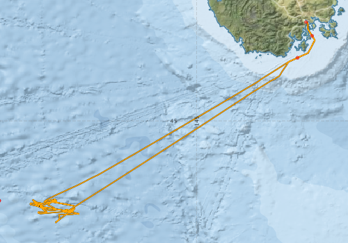
Voyage extents: 47° 11.2' S to 42° 53.2' S 141° 26.7' E to 147° 31.5' E Get voyage track shapefile Get CSV
Marlin Metadata:-
Participants - on ship:-
| Name | Role | Organisation |
|---|---|---|
| Adam Stephens | Moorings | University of Tasmania - Hobart |
| Eric Schulz | Moorings, meteorology | Bureau of Meteorology |
| Mark Rosenberg | Moorings, CTD, glider, floats | Antarctic Cooperative Research Centre |
| Pamela Brodie | Voyage Manager / Computing support | CSIRO Oceans & Atmosphere - Hobart |
| Peter Dunn | MNF Electronics Support | CSIRO Oceans & Atmosphere - Hobart |
| Peter Jansen | Moorings, electronics | Antarctic Cooperative Research Centre |
| Pier van der Merwe | Moorings | Antarctic Cooperative Research Centre |
| Stephen Bray | Moorings, sediment traps | Antarctic Cooperative Research Centre |
| Stephen McCullum | Observer | CSIRO Oceans & Atmosphere - Hobart |
| Tom Trull | Chief Investigator | Antarctic Cooperative Research Centre |
This list includes those that may have only been on part of the voyage. See voyage reports on 'Reports and Maps' tab for details.
Marine National Facility Reports - plans, summaries and data processing
-
SS2010_V07 Voyage Plan
- includes objectives, investigator details, proposed data collection, voyage track and equipment to be used.
-
SS2010_V07 Underway Data Processing Report
- details of data processing steps, calibration information, instruments used and any issues with the data.
-
SS2010_V07 Scientific Highlight
- report of the key outputs
-
SS2010_V07 Voyage Summary
- includes preliminary results, voyage narrative, types of data collected with C77/ROSCOP codes.
-

Publications, reports and datasets from this voyage.
Dataset
- Bakker, Dorothee C E; Pfeil, Benjamin; Smith, Karl; Hankin, Steven; Olsen, Are; Alin, Simone R; Cosca, Catherine E; Harasawa, Sumiko; Kozyr, Alexander; Nojiri, Yukihiro; O'Brien, Kevin M; Schuster, Ute; Telszewski, Maciej; Tilbrook, Bronte; Wada, Chisato; Akl, John; Barbero, Leticia; Bates, Nicolas R; Boutin, Jacqueline; Bozec, Yann; Cai, Wei-Jun; Castle, Robert D; Chavez, Francisco P; Chen, Lei; Chierici, Melissa; Currie, Kim I; de Baar, Hein J W; Evans, Wiley; Feely, Richard A; Fransson, Agneta; Gao, Zhongyong; Hales, Burke; Hardman-Mountford, Nicolas J; Hoppema, Mario; Huang, Wei-Jen; Hunt, Christopher W; Huss, Betty; Ichikawa, Tadafumi; Johannessen, Truls; Jones, Elizabeth M; Jones, Steve D; Jutterstrøm, Sara; Kitidis, Vassilis; Körtzinger, Arne; Landschützer, Peter; Lauvset, Siv K; Lefèvre, Nathalie; Manke, Ansley; Mathis, Jeremy T; Merlivat, Liliane; Metzl, Nicolas; Murata, Akihiko; Newberger, Timothy; Omar, Abdirahman M; Ono, Tsuneo; Park, Geun-Ha; Paterson, Kristina; Pierrot, Denis; Ríos, Aida F; Sabine, Christopher L; Saito, Shu; Salisbury, Joe; Sarma, Vedula V S S; Schlitzer, Reiner; Sieger, Rainer; Skjelvan, Ingunn; Steinhoff, Tobias; Sullivan, Kevin; Sun, Heng; Sutton, Adrienne; Suzuki, Toru; Sweeney, Colm; Takahashi, Taro; Tjiputra, Jerry; Tsurushima, Nobuo; van Heuven, Steven; Vandemark, Doug; Vlahos, Penny; Wallace, Douglas WR; Wanninkhof, Rik; Watson, Andrew J (2014): Surface Ocean CO2 Atlas (SOCAT) V2. PANGAEA, 10.1594/PANGAEA.811776
Journal Article
- Eriksen, R., Trull, TW., Davies, D., Jansen, P., Davidson, A T., Westwood, K., van den Enden, R. (2018) 'Seasonal succession of phytoplankton community structure from autonomous sampling at the Australian Southern Ocean Time Series (SOTS) observatory', Marine Ecology Progress Series 589 pp 13-31. 10.3354/meps12420
- Weeding, Ben,Trull, Thomas W. (2014) Hourly oxygen and total gas tension measurements at the Southern Ocean Time Series site reveal winter ventilation and spring net community production. Journal of Geophysical Research: Oceans 119 pp348-358. 10.1002/2013JC009302
Search for publications, reports and datasets from this and other voyages
Data publishing
This is a list of online datasets hosted by CSIRO. Other processed datasets hosted by collaborating organisations may be found on the 'Metadata' or "Reports, Publications and Maps' tab.
Use the Get data link on the right to extract data using the NCMI Data Trawler.
| Data Stream | Data Summary | Get data | ||||||||||||||
|---|---|---|---|---|---|---|---|---|---|---|---|---|---|---|---|---|
| ADCP Data |
|
Get Data from Trawler Download NetCDF ss2010_v07_adcp_nc.zip Overview ADCP Dataset HTML Download Processing Report ss2010_v07ADCP.pdf |
||||||||||||||
| Multibeam echosounder |
|
Get Data from Trawler |
||||||||||||||
| pCO2 |
|
External link - download datafile at IMOS |
||||||||||||||
| Underway |
|
Get Data from Trawler Download NetCDF dataset ss2010_v07UWYnc.zip |
Search for events from this voyage and others
Events ordered by start time:- Click on column header to sort. Use link on 'When' to see full details. Use the CSV button at the bottom to export data.
| When (UTC) | Latitude | Longitude | Instrument | Identifier | Action | Log | Subject / Comments |
|---|---|---|---|---|---|---|---|
| 2010-09-09 00:00 [view ] | -46.9347 | 142.2583 | Pulse | Pulse 7 | deploy | ||
| 2010-09-09 00:00 [view ] | -46.8335 | 141.6570 | SAZ | SAZ47-12 | recover | ||
| 2010-09-12 00:00 [view ] | -46.7072 | 141.7762 | Glider | SG521 iRobot | deploy | SOTS group. Deployed with Argo floats | |
| 2010-09-12 00:00 [view ] | -46.8304 | 141.6497 | SAZ | SAZ47-13 | deploy | ||
| 2010-09-13 07:53 [view ] | -46.7100 | 140.7800 | Argo float [view] | 6957 | deploy | Owner: Tom Trull CTD Type: SBE41 Serial number: 3018 | |
| 2010-09-13 07:54 [view ] | -46.7100 | 140.7800 | Argo float [view] | 6958 | deploy | Owner: Tom Trull CTD Type: SBE41 Serial number: 3019 |
Deployments by start time:- Click on column header to sort. Use link on 'Deployment' to see full details. Use the CSV button at the bottom to export data (tab delimited).
Search for deployments from this voyage and others
| Deployment | Operation | Station | Cast | Gear | Project | Start and end times | Start Location | End Location | Depth | Description | |||
|---|---|---|---|---|---|---|---|---|---|---|---|---|---|
| Underway System [details] | Air Temperature Sensor-HMT333,Barometer,Doppler speed log,Fluorometer WS3S-443P,Humidity Sensor-HMT333,IMOS Port Pyranometer-SN 35122F3,IMOS Port Radiometer-SN 35111F3,IMOS Stbd Pyranometer-SN 35123F3,IMOS Stbd Radiometer-SN 35093F3,IMOS rain gauge,IMOS rain gauge,IMOS wind monitor,IMOS wind monitor,Licor-UWQ 3708,RM Young 05106 wind monitor-75621,RM Young 05106 wind monitor-75621,RM Young 05106 wind monitor-75621,RM Young Rain Gauge,Remote Temperature (T)-SN 2621,Seapath 200,Seapath 200,Seapath 200,Simrad EK60 echosounder,ThermoSalinoGraph (TSG)-SS-SN 1777 | 2365 | 2010-09-06 21:50 | 2010-09-14 21:52 | -42.8863 | 147.3385 | -42.9164 | 147.3767 | |||||
| Multibeam echosounder [details] | EM300 Multibeam Echosounder | 2010-09-06 23:53 | 2010-09-15 02:52 | -43.1811 | 147.4651 | -42.8864 | 147.3387 | 5947.7 | |||||
| ADCP Data [details] | RDI Ocean Surveyor Acoustic Doppler current profiler | 2365 | 2010-09-07 02:11 | 2010-09-14 20:56 | -43.6504 | 147.1540 | -42.9090 | 147.3717 | 813 | ||||
| ARGO float [details] | 6957 | 2394 | 2010-09-13 07:53 | -46.7100 | 140.7800 | Owner: Tom Trull CTD Type: SBE41 Serial number: 3018 | |||||||
| ARGO float [details] | 6958 | 2394 | 2010-09-13 07:54 | -46.7100 | 140.7800 | Owner: Tom Trull CTD Type: SBE41 Serial number: 3019 | |||||||