Voyage details and related metadata, reports, events and data.
IN2017_E03
- is a Marine National Facility ![]() voyage
voyage
Title: Brisbane Port Period Sea Trials
Voyage details on MNF site: https://mnf.csiro.au/en/Voyages/IN2017_E03
Period: 2017-08-20 07:00 to 2017-08-23 08:30 UTC
Duration: 3.06 days
From: Brisbane To: Brisbane
Region: Queensland coast central
Ship: Investigator (RV) [details]
Description: RV Investigator research voyage in2017_e03, titled "Brisbane Port Period Sea Trials." The primary objective was to complete sea trials of onboard equipment as described in the Voyage Plan.
Leader: Stephen McCullum (voyage manager)
Project: Investigator - general vessel operations, gear trials, etc. [details] Primary
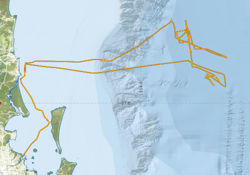
Voyage extents: 27° 23.0' S to 26° 24.4' S 153° 08.9' E to 154° 36.8' E Get voyage track shapefile Get CSV
Marlin Metadata:-
Cruise Summary Report at SeaDataNet:-
Participants - on ship:-
| Name | Role | Organisation | Project |
|---|---|---|---|
| Mark Scanlon | Deputy Voyage Manager | Marine National Facility | Voyage Management on RV Investigator |
| Stephen McCullum | Voyage Manager | Marine National Facility | Voyage Management on RV Investigator |
This list includes those that may have only been on part of the voyage. See voyage reports on 'Reports and Maps' tab for details.
Marine National Facility Reports - plans, summaries and data processing
-
IN2017_E03 Voyage Plan
- includes objectives, investigator details, proposed data collection, voyage track and equipment to be used.
- View Survey map
Search for publications, reports and datasets from this and other voyages
Data publishing
This is a list of online datasets hosted by CSIRO. Other processed datasets hosted by collaborating organisations may be found on the 'Metadata' or "Reports, Publications and Maps' tab.
Use the Get data link on the right to extract data using the NCMI Data Trawler.
| Data Stream | Data Summary | Get data | ||||||||||
|---|---|---|---|---|---|---|---|---|---|---|---|---|
| Multibeam echosounder |
|
Get Data from Trawler |
||||||||||
| Radon measurements |
|
Get Data from Trawler Download RV Investigator Radon dataset (XLSX) |
||||||||||
| Singlebeam echosounder |
|
Get Data from Trawler Geophysical Survey and Mapping acquisition report |
||||||||||
| Underway | No data | |||||||||||
| XBT Profile |
|
Get Data from Trawler |
Caveat: this event log was authored on the voyage using either a standalone logging system called ELOG or more recently an inhouse event logging tool called Everlog. For this reason, some positions are unknown and may be resolved using the logged time and the underway dataset for the voyage.
Search for events from this voyage and others
Events ordered by start time:- Click on column header to sort. Use link on 'When' to see full details. Use the CSV button at the bottom to export data.
| When (UTC) | Latitude | Longitude | Instrument | Identifier | Action | Log | Subject / Comments |
|---|---|---|---|---|---|---|---|
| 2017-08-21 02:43 [view ] | -26.8308 | 154.5965 | EM122 [view] | SVP | GSM_in2017_e03 | New SVP applied in2017_e03.asvp SST= 23.3 (in SVP builder, actual SST =23C) | |
| 2017-08-21 02:44 [view ] | -26.8317 | 154.5965 | ME70 [view] | Start | GSM_in2017_e03 | ME70 testing various configurations for interference | |
| 2017-08-21 05:32 [view ] | -26.7900 | 154.4657 | EM122 [view] | Stop | GSM_in2017_e03 | ||
| 2017-08-21 06:18 [view ] | -26.7905 | 154.4653 | EM122 [view] | Start | GSM_in2017_e03 | ||
| 2017-08-21 14:59 [view ] | -26.8335 | 154.4900 | XBT [view] | Drop | GSM_in2017_e03 | XBT drop 1 SST= 23.017 | |
| 2017-08-21 15:00 [view ] | -26.8328 | 154.4890 | EM122 [view] | SVP | GSM_in2017_e03 | New SVP applied in2017_e03_xbt_001a.asvp | |
| 2017-08-21 15:06 [view ] | -26.8385 | 154.4905 | EM122 [view] | Start | GSM_in2017_e03 | Start roll cal line 1 Heading 114 | |
| 2017-08-21 15:42 [view ] | -26.8668 | 154.5123 | EM122 [view] | Start | GSM_in2017_e03 | Start roll cal line 2 Heading 323 | |
| 2017-08-21 16:37 [view ] | -26.8073 | 154.5253 | EM122 [view] | Start | GSM_in2017_e03 | Start cal line 3 HDG 114 Beam angles 60/60 | |
| 2017-08-21 17:13 [view ] | -26.8418 | 154.5542 | EM122 [view] | Start | GSM_in2017_e03 | Start cal line 3 HDG 322 | |
| 2017-08-21 19:58 [view ] | -26.7437 | 154.3887 | EM122 [view] | Stop | GSM_in2017_e03 | Stop on CTD station | |
| 2017-08-22 09:37 [view ] | -26.4440 | 154.3242 | EM122 [view] | Start | GSM_in2017_e03 | ||
| 2017-08-22 14:28 [view ] | -26.5610 | 154.3378 | XBT [view] | GSM_in2017_e03 | XBT drop 2 | ||
| 2017-08-22 14:28 [view ] | -26.5613 | 154.3375 | EM122 [view] | SVP | GSM_in2017_e03 | New SVP applied in2017_e03_xbt002.asvp | |
| 2017-08-22 14:35 [view ] | -26.5632 | 154.3275 | EM122 [view] | Start | GSM_in2017_e03 | Offset values zeroed in SIS | |
| 2017-08-22 14:38 [view ] | -26.5648 | 154.3200 | EM122 [view] | Start | GSM_in2017_e03 | Start yaw calibration line 1 HDG 257 Max beam angles 60/60 Speed 6 kts Beam spacing HDEQUDST | |
| 2017-08-22 15:04 [view ] | -26.5697 | 154.2740 | EM122 [view] | Other | GSM_in2017_e03 | Pitch stabliization off | |
| 2017-08-22 15:17 [view ] | -26.5455 | 154.2667 | EM122 [view] | Start | GSM_in2017_e03 | Start pitch line 1 HDG 345 | |
| 2017-08-22 15:47 [view ] | -26.4968 | 154.2537 | EM122 [view] | GSM_in2017_e03 | Pitch stabilization on | ||
| 2017-08-22 15:54 [view ] | -26.4927 | 154.2655 | EM122 [view] | GSM_in2017_e03 | Start yaw calibration line 2 HDG 64 | ||
| 2017-08-22 16:29 [view ] | -26.4833 | 154.3132 | EM122 [view] | Start | GSM_in2017_e03 | Start yaw calibration line 2 HDG 266 | |
| 2017-08-22 16:57 [view ] | -26.4938 | 154.2597 | EM122 [view] | GSM_in2017_e03 | Pitch stabliization off | ||
| 2017-08-22 17:04 [view ] | -26.5048 | 154.2542 | EM122 [view] | GSM_in2017_e03 | Start pitch line 2/yaw line 3 HDG 169 | ||
| 2017-08-22 18:06 [view ] | -26.4845 | 154.3415 | EM122 [view] | Start | GSM_in2017_e03 | Start yaw calibration line 4 HDG 168 | |
| 2017-08-22 23:20 [view ] | -26.6652 | 154.5700 | Techsas1 [view] | in2017_e03 | Reset after GUI freeze | ||
| 2017-08-22 23:20 [view ] | -26.6650 | 154.5697 | Techsas2 [view] | restarted | in2017_e03 | Reset after GUI freeze | |
| 2017-08-23 05:16 [view ] | -26.5409 | 154.2558 | EM122 [view] | Start | GSM_in2017_e03 | ||
| 2017-08-23 14:33 [view ] | -26.6388 | 153.9030 | EM710 [view] | Other | GSM_in2017_e03 | Offset values zeroed in SIS, pitch stabliization off | |
| 2017-08-23 15:15 [view ] | -26.7006 | 153.7734 | XBT [view] | GSM_in2017_e03 | XBT drop 3, one failed | ||
| 2017-08-23 15:15 [view ] | -26.7006 | 153.7699 | EM710 [view] | SVP | GSM_in2017_e03 | New SVP applied in2017_e03_xbt003.asvp | |
| 2017-08-23 15:15 [view ] | -26.7006 | 153.7699 | EM122 [view] | SVP | GSM_in2017_e03 | New SVP applied in2017_e03_xbt003.asvp | |
| 2017-08-23 15:19 [view ] | -26.7007 | 153.7568 | EM122 [view] | Stop | GSM_in2017_e03 | Stop for EM710 calibration | |
| 2017-08-23 15:21 [view ] | -26.7007 | 153.7521 | EM710 [view] | Start | GSM_in2017_e03 | At calibration site | |
| 2017-08-23 15:43 [view ] | -26.7008 | 153.7215 | EM710 [view] | GSM_in2017_e03 | Dual swath mode off | ||
| 2017-08-23 15:46 [view ] | -26.7010 | 153.7260 | EM710 [view] | Start | GSM_in2017_e03 | Start Cal line 1 (pitch1/roll1/yaw1) HDG 92 Beam angles 60/60 HD EQUDST Dual swath off, pitch stabilization off 40-100kHz | |
| 2017-08-23 16:11 [view ] | -26.7008 | 153.7494 | EM710 [view] | Start | GSM_in2017_e03 | Start Cal line 2 (pitch2/roll2) HDG 268 | |
| 2017-08-23 16:33 [view ] | -26.6901 | 153.7331 | EM710 [view] | Start | GSM_in2017_e03 | Start cal line 3 (yaw2) HDG 93 | |
| 2017-08-23 16:54 [view ] | -26.6898 | 153.7461 | EM710 [view] | Start | GSM_in2017_e03 | Start Cal line 4- additional line HDG 271 | |
| 2017-08-23 22:42 [view ] | -27.0414 | 153.2586 | EM710 [view] | GSM_in2017_e03 | Stop logging | ||
| 2017-08-23 22:43 [view ] | -27.0429 | 153.2625 | EK60 [view] | Stop | GSM_in2017_e03 | Stop pinging |
Deployments by start time:- Click on column header to sort. Use link on 'Deployment' to see full details. Use the CSV button at the bottom to export data (tab delimited).
Search for deployments from this voyage and others
| Deployment | Operation | Station | Cast | Gear | Project | Start and end times | Start Location | End Location | Depth | Description | |||
|---|---|---|---|---|---|---|---|---|---|---|---|---|---|
| XBT Cast [details] | Sippican Deep Blue | 2548 | 2017-08-22 00:49 | 1100.3 | |||||||||
| XBT Cast [details] | Sippican Deep Blue | 2548 | 2017-08-23 00:22 | 1100.3 | |||||||||
| XBT Cast [details] | Sippican Deep Blue | 2548 | 2017-08-24 01:04 | 875 | |||||||||
| XBT Cast [details] | Sippican Deep Blue | 2548 | 2017-08-24 01:06 | 66 | |||||||||
| XBT Cast [details] | Sippican Deep Blue | 2548 | 2017-08-24 01:07 | 23.4 | |||||||||
| XBT Cast [details] | Sippican Deep Blue | 2548 | 2017-08-24 01:09 | 1100.3 | |||||||||