Voyage details and related metadata, reports, events and data.
IN2016_E01
- is a Marine National Facility ![]() voyage
voyage
Title: East Tasman Plateau – key to unravelling the onset of the Antarctic Circumpolar Current, MNF Equipment Sea Trials
Voyage details on MNF site: https://mnf.csiro.au/en/Voyages/IN2016_E01
Period: 2016-08-17 08:00 to 2016-08-21 22:00 UTC
Duration: 4.58 days
From: Hobart To: Hobart
Region: East Tasman Plateau, Storm Bay,
Ship: Investigator (RV) [details]
Description: Scientific Objectives: 1) Dredge volcanic and sedimentary rocks to obtain new, rigorous age and paleo-depth constraints for the Cascade Seamount. Underway bathymetric data will be used to refine dredge targets. 2) Collect sediment cores across a depth transect to enable work investigating paleo-oceanographic conditions using proxies. Preferably at least a multicore proximal to IODP site 1172, and piston cores at the mid- and shallow-depth sites. 3) Collect high resolution swath bathymetry and sub-bottom profile data to see how far recent sediment flows extend from the Cascade Seamount towards IODP site 1172, to test the hypothesis that downslope transport resulted in the observed sediment patterns in core 1172. Existing coverage and resolution of bathymetry across the East Tasman Plateau is insufficient to resolve this question. 4) CTD to complement the sediment core data if possible. Alternative is for clean underway surface supply samples to be taken where CTD not possible.
Leader: Joanne Whittaker (IMAS)
Projects:
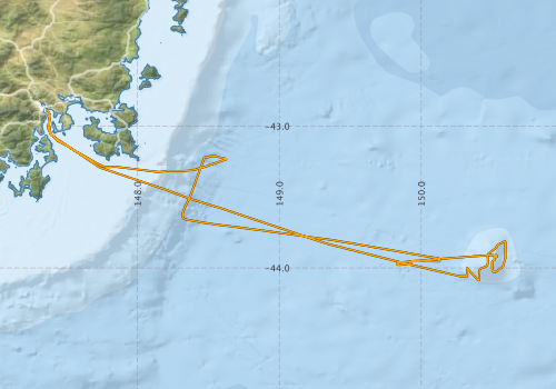
Voyage extents: 44° 05.3' S to 42° 53.3' S 147° 21.3' E to 150° 35.6' E Get voyage track shapefile Get CSV
Marlin Metadata:-
Cruise Summary Report at SeaDataNet:-
Participants - on ship:-
| Name | Role | Organisation | Project |
|---|---|---|---|
| Don McKenzie | Deputy Voyage Manager | Marine National Facility | Voyage Management on RV Investigator |
| Doug Thost | Voyage Manager | Marine National Facility | Voyage Management on RV Investigator |
| Jo Whittaker | Chief Scientist | University of Tasmania | East Tasman Plateau –key to unravelling the onset of the Antarctic Circumpolar Current |
| Simon Williams | Alternate Chief Scientist | University of Sydney | East Tasman Plateau –key to unravelling the onset of the Antarctic Circumpolar Current |
This list includes those that may have only been on part of the voyage. See voyage reports on 'Reports and Maps' tab for details.
Marine National Facility Reports - plans, summaries and data processing
-
IN2016_E01 Voyage Plan
- includes objectives, investigator details, proposed data collection, voyage track and equipment to be used.
-
IN2016_E01 Voyage Summary
- includes preliminary results, voyage narrative, types of data collected with C77/ROSCOP codes.
-
IN2016_E01 Scientific Highlights
- report of the key outputs
- View Survey map
Publications, reports and datasets from this voyage.
Conference abstract
- Mundana, R and Johnson, SC and Whittaker, JM and Carey, R and Sauermilch, I and Fox, JM, Rocks from the Cascade Seamount: an archive of the unzipping of Gondwana and the initiation of the ACC?, AGU Chapman Conference 2017 Abstracts, 29 January-03 February, Hobart, Tasmania (2017) [Non Refereed Conference Paper] External link to reference
Dataset
- Whittaker, Joanne. and Carey, Rebecca (2016) Dredge Samples from IN2016_E01. IMAS Metadata External link to reference
- Whittaker, Joanne; Boyd, Matt; Nau, Amy; Frances Cooke; Navidad, Cisco; Taylor, Charlie; Plunkett, Tom (2022): IN2016_E01 East Tasman Plateau Bathymetry 10m - 210m Multi-resolution AusSeabed products. v1. CSIRO. Data Collection 10.25919/xj7q-dp39
Journal Article
- Vorsanger, S. L., Scher, H., Johnson, S., Mundana, R., Sauermilch, I., Duggan, B., & Whittaker, J. M. (2017). Resolving the subsidence anomaly of the East Tasman plateau using new insights from the Cascade Seamount, southwest Tasman Sea . American Geophysical Union Fall Meeting, Vol. 2017 External link to reference
Thesis
- Mabee, A. (2018) Plume volcanism controls Site 1172 sediment provenance and deposition pre-Antarctic Circumpolar Current. Masters Thesis at Macquarie University
- Mundana, R. (2018) The geological evolution of the Cascade Seamount, Tasman Sea. Honours Thesis at the University of Tasmania
- Vorsanger, S. (2018) Determining the subsidence rate of the Cascade Seamount using Strontium Isotope Stratigraphy. Masters Thesis at the University of South Carolina
Search for publications, reports and datasets from this and other voyages
Data publishing
This is a list of online datasets hosted by CSIRO. Other processed datasets hosted by collaborating organisations may be found on the 'Metadata' or "Reports, Publications and Maps' tab.
Use the Get data link on the right to extract data using the NCMI Data Trawler.
| Data Stream | Data Summary | Get data | ||||||||||
|---|---|---|---|---|---|---|---|---|---|---|---|---|
| Gravity Measurements |
|
Get Data from Trawler Geophysical Survey and Mapping acquisition report |
||||||||||
| Multibeam echosounder |
|
Get Data from Trawler |
||||||||||
| pCO2 |
|
External link - download datafile at IMOS Data fields and units document (.pdf) |
||||||||||
| Sub-bottom profiler |
|
Get Data from Trawler Geophysical Survey and Mapping data acquisition and processing report |
||||||||||
| XBT Profile |
|
Get Data from Trawler |
Caveat: this event log was authored on the voyage using either a standalone logging system called ELOG or more recently an inhouse event logging tool called Everlog. For this reason, some positions are unknown and may be resolved using the logged time and the underway dataset for the voyage.
Search for events from this voyage and others
Events ordered by start time:- Click on column header to sort. Use link on 'When' to see full details. Use the CSV button at the bottom to export data.
| When (UTC) | Latitude | Longitude | Instrument | Identifier | Action | Log | Subject / Comments |
|---|---|---|---|---|---|---|---|
| 2016-08-17 09:58 [view ] | -42.9730 | 147.3794 | Underway Seawater Data | in2016_e01 | Pumps on | ||
| 2016-08-17 13:36 [view ] | -42.9733 | 147.3473 | EK60 [view] | Start | GSM_in2016_e01 | Calibrate 333kHz Full Beam Map power 40W Pulse length: 1.024 | |
| 2016-08-17 14:23 [view ] | -42.9733 | 147.3473 | EK60 [view] | Start | GSM_in2016_e01 | Calibrate 200kHz Full Beam Map power 105W Pulse length: 1.024 | |
| 2016-08-17 15:01 [view ] | -42.9733 | 147.3473 | EK60 [view] | Start | GSM_in2016_e01 | Calibrate 200kHz On Axis power 105db Pulse length: 1.024 | |
| 2016-08-17 15:21 [view ] | -42.9733 | 147.3473 | EK60 [view] | Start | GSM_in2016_e01 | Calibrate 120kHz Full Beam Map power 250db Pulse length: 1.024 | |
| 2016-08-17 15:44 [view ] | -42.9733 | 147.3473 | EK60 [view] | Start | GSM_in2016_e01 | Calibrate 120kHz On Axis Map power 250db Pulse length: 1.024 | |
| 2016-08-17 17:29 [view ] | -42.9733 | 147.3473 | EK60 [view] | Start | GSM_in2016_e01 | Calibrate 70kHz Full Beam Map power 750W Pulse length: 2.048 | |
| 2016-08-17 17:49 [view ] | -42.9733 | 147.3473 | EK60 [view] | Start | GSM_in2016_e01 | Calibrate 70kHz On Axis Map power 750W Pulse length: 2.048 | |
| 2016-08-17 17:54 [view ] | -42.9733 | 147.3473 | EK60 [view] | Start | GSM_in2016_e01 | Calibrate 70kHz On Axis Map power 750W Pulse length: 1.024 | |
| 2016-08-17 17:57 [view ] | -42.9733 | 147.3473 | EK60 [view] | Start | GSM_in2016_e01 | Calibrate 70kHz On Axis Map power 750W Pulse length: 0.512 | |
| 2016-08-17 18:04 [view ] | -42.9733 | 147.3473 | EK60 [view] | Start | GSM_in2016_e01 | Calibrate 38kHz Full Beam Map power 2000W Pulse length: 2.048 | |
| 2016-08-17 18:27 [view ] | -42.9733 | 147.3473 | EK60 [view] | Start | GSM_in2016_e01 | Calibrate 38kHz On Axis Map power 2000W Pulse length: 2.048 | |
| 2016-08-17 18:27 [view ] | -42.9733 | 147.3473 | EK60 [view] | Start | GSM_in2016_e01 | Calibrate 38kHz On Axis Map power 2000W Pulse length: 4.096 | |
| 2016-08-17 18:34 [view ] | -42.9733 | 147.3473 | EK60 [view] | Start | GSM_in2016_e01 | Calibrate 38kHz On Axis Map power 2000W Pulse length: 1.024 | |
| 2016-08-17 18:36 [view ] | -42.9733 | 147.3473 | EK60 [view] | Start | GSM_in2016_e01 | Calibrate 38kHz On Axis Map power 2000W Pulse length: 0.512 | |
| 2016-08-17 18:36 [view ] | -42.9733 | 147.3473 | EK60 [view] | Start | GSM_in2016_e01 | Calibrate 18kHz Full Beam Map power 2000W Pulse length: 2.048 | |
| 2016-08-17 19:17 [view ] | -42.9733 | 147.3473 | EK60 [view] | Start | GSM_in2016_e01 | Calibrate 18kHz On Axis Map power 2000W Pulse length: 2.048 | |
| 2016-08-17 19:22 [view ] | -42.9733 | 147.3473 | EK60 [view] | Start | GSM_in2016_e01 | Calibrate 18kHz On Axis Map power 2000W Pulse length: 4.096 | |
| 2016-08-17 19:25 [view ] | -42.9733 | 147.3473 | EK60 [view] | Start | GSM_in2016_e01 | Calibrate 18kHz On Axis Map power 2000W Pulse length: 8.192 | |
| 2016-08-17 19:25 [view ] | -42.9733 | 147.3473 | EK60 [view] | Start | GSM_in2016_e01 | Calibrate 18kHz On Axis Map power 2000W Pulse length: 1.024 | |
| 2016-08-17 19:27 [view ] | -42.9733 | 147.3473 | EK60 [view] | Start | GSM_in2016_e01 | Calibrate 18kHz On Axis Map power 2000W Pulse length: 0.512 | |
| 2016-08-17 20:49 [view ] | -43.0235 | 147.3734 | EK60 [view] | Start | GSM_in2016_e01 | Start Logging EK60 | |
| 2016-08-17 21:13 [view ] | -43.0897 | 147.4240 | EM710 [view] | Start | GSM_in2016_e01 | Start Logging EM710 | |
| 2016-08-18 00:15 [view ] | -43.4160 | 148.1038 | EM122 [view] | Start | GSM_in2016_e01 | ||
| 2016-08-18 00:32 [view ] | -43.4402 | 148.1743 | EM710 [view] | Stop | GSM_in2016_e01 | Stop Logging EM710 | |
| 2016-08-18 02:59 [view ] | -43.6410 | 148.7724 | Aerodyne [view] | Reboot | in2016_e01 | Restarted for network change | |
| 2016-08-18 03:01 [view ] | -43.6438 | 148.7808 | Piccaro [view] | Reboot | in2016_e01 | Restarted for network change | |
| 2016-08-18 03:02 [view ] | -43.6452 | 148.7850 | Oxygen Analyser [view] | Reboot | in2016_e01 | Restarted for network change | |
| 2016-08-18 04:32 [view ] | -43.7740 | 149.1694 | Radiometer - Met | Stop | in2016_e01 | Port PIR/PSP started Hardware fault on interface for port PIR/PSP. Replaced with spare from stock, now running. | |
| 2016-08-19 04:50 [view ] | -43.8097 | 150.5881 | CCN [view] | maintenance | in2016_e01 | Extended milli-Q intake tube for instrument Requested by Aspendale folks | |
| 2016-08-19 05:21 [view ] | -43.8097 | 150.5882 | SMPS [view] | Start | in2016_e01 | Restarted scheduler Noted that this instrument was not running despite being started at the beginning of the voyage. | |
| 2016-08-19 05:36 [view ] | -43.8096 | 150.5877 | Ozone Detector [view] | Start | in2016_e01 | Turned power on This had been running but had been turned off | |
| 2016-08-20 11:49 [view ] | -43.9297 | 150.1066 | SBP [view] | Other | GSM_in2016_e01 | SBP restarted to update time to UTC | |
| 2016-08-20 18:31 [view ] | -43.7194 | 148.7668 | Gravity Meter [view] | Stop | GSM_in2016_e01 | Gravity meter clamped due to rough weather | |
| 2016-08-20 22:21 [view ] | -43.3635 | 148.4197 | EK60 [view] | Other | GSM_in2016_e01 | EK60 turned to passive All EK60 frequencies were turned to passive and the 75kHz ADCP turned off in order to test noise interference | |
| 2016-08-20 22:21 [view ] | -43.3699 | 148.4173 | Other [view] | Stop | GSM_in2016_e01 | 75kHz ADCP turned off 75kHz ADCP stopped pinging for Ek60 interference testing | |
| 2016-08-20 22:25 [view ] | -43.3571 | 148.4220 | Other [view] | Stop | GSM_in2016_e01 | 150Hz ADCP turned off 150kHz ADCP stopped pinging for Ek60 interference testing | |
| 2016-08-20 22:27 [view ] | -43.3506 | 148.4244 | Other [view] | Start | GSM_in2016_e01 | 150kHz ADCP start pinging | |
| 2016-08-20 22:43 [view ] | -43.2989 | 148.4435 | EK60 [view] | Start | GSM_in2016_e01 | EK60 turned back to active mode | |
| 2016-08-20 22:43 [view ] | -43.2989 | 148.4435 | Other [view] | Start | GSM_in2016_e01 | 75 kHz ADCP start pinging | |
| 2016-08-20 23:31 [view ] | -43.2223 | 148.4926 | EK60 [view] | Other | GSM_in2016_e01 | Changed Environment setting to 1500m/s Previously set at 1496.5 for Ek60 calibration on 17/08/16 | |
| 2016-08-21 02:00 [view ] | -43.2328 | 148.6312 | Gravity Meter [view] | Start | GSM_in2016_e01 | Gravity meter turned back on First time booting up the gravity meter would not unclamp. The computer was rebooted, and then the meter unclamped and started normal. | |
| 2016-08-21 03:44 [view ] | -43.2333 | 148.6312 | Other [view] | GSM_in2016_e01 | Piston core at bottom 3236m | ||
| 2016-08-21 05:10 [view ] | -43.2337 | 148.6315 | Other [view] | GSM_in2016_e01 | Piston core retrieved 3238m | ||
| 2016-08-21 12:49 [view ] | -43.3170 | 148.2472 | EM710 [view] | Start | GSM_in2016_e01 | Start Logging EM710 | |
| 2016-08-21 13:54 [view ] | -43.3030 | 147.9838 | EM710 [view] | SVP | GSM_in2016_e01 | New SVP applied in2016_e01_sst003 | |
| 2016-08-21 13:54 [view ] | -43.3030 | 147.9838 | EM122 [view] | SVP | GSM_in2016_e01 | New SVP applied in2016_e01_sst003 | |
| 2016-08-21 14:05 [view ] | -43.2978 | 147.9347 | EM710 [view] | Start | GSM_in2016_e01 | Dual swath mode turned on | |
| 2016-08-21 14:37 [view ] | -43.2848 | 147.8383 | EM710 [view] | Stop | GSM_in2016_e01 | Dual swath turned off | |
| 2016-08-21 14:37 [view ] | -43.2848 | 147.8383 | EM710 [view] | Start | GSM_in2016_e01 | Logging stationary data on shallow mode | |
| 2016-08-21 14:45 [view ] | -43.2848 | 147.8383 | EM710 [view] | Start | GSM_in2016_e01 | Logging stationary data on very shallow mode | |
| 2016-08-21 14:58 [view ] | -43.2848 | 147.8383 | EM710 [view] | Start | GSM_in2016_e01 | Logging stationary data on medium mode | |
| 2016-08-21 15:02 [view ] | -43.2848 | 147.8383 | EM122 [view] | Start | GSM_in2016_e01 | Logging stationary data on medium mode | |
| 2016-08-21 15:08 [view ] | -43.2848 | 147.8383 | EM710 [view] | Start | GSM_in2016_e01 | Logging stationary data on deep mode | |
| 2016-08-21 15:10 [view ] | -43.2848 | 147.8383 | EM122 [view] | Start | GSM_in2016_e01 | Logging stationary data on shallow mode | |
| 2016-08-21 15:16 [view ] | -43.2848 | 147.8383 | EM710 [view] | Start | GSM_in2016_e01 | Logging stationary data on very deep mode | |
| 2016-08-21 15:23 [view ] | -43.2848 | 147.8383 | EM710 [view] | Start | GSM_in2016_e01 | Logging stationary data on extra deep mode | |
| 2016-08-21 15:26 [view ] | -43.2848 | 147.8383 | EM710 [view] | Start | GSM_in2016_e01 | Logging stationary data on very shallow mode | |
| 2016-08-21 17:05 [view ] | -43.2457 | 147.6850 | EM122 [view] | Stop | GSM_in2016_e01 | Stop Logging EM122 | |
| 2016-08-21 18:01 [view ] | -43.1543 | 147.5287 | EM710 [view] | SVP | GSM_in2016_e01 | New SVP applied in2016_e01_sst004 | |
| 2016-08-21 18:01 [view ] | -43.1543 | 147.5287 | EM122 [view] | SVP | GSM_in2016_e01 | New SVP applied in2016_e01_sst004 |
Deployments by start time:- Click on column header to sort. Use link on 'Deployment' to see full details. Use the CSV button at the bottom to export data (tab delimited).
Search for deployments from this voyage and others
| Deployment | Operation | Station | Cast | Gear | Project | Start and end times | Start Location | End Location | Depth | Description | |||
|---|---|---|---|---|---|---|---|---|---|---|---|---|---|
| XBT Cast [details] | Sippican Deep Blue | 2548 | 2016-08-17 22:58 | 1100.3 | |||||||||