Voyage details and related metadata, reports, events and data.
FR 06/88
(alternative identifier: FR198806)
- is a Marine National Facility  voyage
Period: 1988-08-19 00:00 to 1988-08-26 00:00 Local
Duration: 7.00 days
From: Cairns To: Townsville
Region: NE slope, Coral Sea
Ship: Franklin [details]
Description: Cruise FR 06/88 was undertaken to sample benthic invertebrates from the continental slope off north eastern Australia (Murray Island to Cape Sidmouth) in the Coral Sea. Survey methods included beam trawls and sled (at depths from 472 m to 2510 m) and underway instrumentation. A diverse range of fauna were collected including pteropods, small molluscs, echinoderms, fish, solitary corals and deep water plankton these will be returned to the Australian Museum and distributed to the relevant specialists. All sediment, pumice and wood collected were also retained for examination.
Leader: P. Hutchings (Australian Museum)
Project: National Facility External Users: P. Hutchings (Australian Museum) [details]
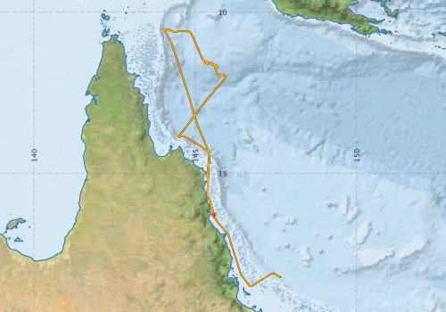
- Franklin Voyage FR 06/88 Underway Data [details]
- Global benthic biogeographical regions and macroecological drivers for ophiuroids [Data set]
- Download from OBIS Australia IPT
- View at - Ocean Biodiversity Information System (OBIS)
Participants - on ship:-
| Name | Role | Organisation |
|---|---|---|
| Angus McEwan | CSIRO Division of Oceanography | |
| Bob Edwards | CSIRO Division of Oceanography | |
| Erik Madsen | CSIRO Division of Oceanography | |
| Ian Loch | Australian Museum | |
| Jan Peterson | Cruise Manager | CSIRO Division of Oceanography |
| Len McKenzie | Queensland Museum | |
| Margaret Atkinson | Australian Museum | |
| Pat Hutchings | Chief Scientist | Australian Museum |
| Robert Paterson | Australian Museum |
This list includes those that may have only been on part of the voyage. See voyage reports on 'Reports and Maps' tab for details.
Marine National Facility Reports - plans, summaries and data processing
- FR198806 Voyage Summary - includes preliminary results, voyage narrative, types of data collected with C77/ROSCOP codes.
- FR198806 Voyage Plan - includes objectives, investigator details, proposed data collection, voyage track and equipment to be used.
-

Publications, reports and datasets from this voyage.
DwC Archive
- Global benthic biogeographical regions and macroecological drivers for ophiuroids [Data set] (Darwin Core Archive) External link to reference
Search for publications, reports and datasets from this and other voyages
Data publishing
This is a list of online datasets hosted by CSIRO. Other processed datasets hosted by collaborating organisations may be found on the 'Metadata' or "Reports, Publications and Maps' tab.
Use the Get data link on the right to extract data using the NCMI Data Trawler.
| Data Stream | Data Summary | Get data | ||||||||||||
|---|---|---|---|---|---|---|---|---|---|---|---|---|---|---|
| Marine biodiversity observations and/or samples |
|
|||||||||||||
| Underway |
|
Deployments by start time:- Click on column header to sort. Use link on 'Deployment' to see full details. Use the CSV button at the bottom to export data (tab delimited).
Search for deployments from this voyage and others
| Deployment | Operation | Station | Cast | Gear | Project | Datetime | Start Location | End Location | Depth range | Max Depth | Description | |||
|---|---|---|---|---|---|---|---|---|---|---|---|---|---|---|
| Start | End | Lat | Lon | Lat | Lon | |||||||||
| Underway System [details] | Simrad EA500 Echosounder | 129 | 1988-08-18 00:00 | 1988-08-26 23:55 | -16.2842 | 145.5770 | -18.2018 | 147.5720 | ||||||