CSIRO Marine Research
CSIRO / MARINE RESEARCH / MARMION LAB / OCEANOGRAPHY
Regional Oceanography Fisheries Satellite Remote Sensing Bibliography
Regional
Oceanography
Fisheries Satellite Remote
Sensing
Bibliography
Regional Oceanography - Coastal Ocean Temperatures Off WA
Site: Rat Island -- Houtman Abrolhos Islands mini-map  | region map | main map

Site
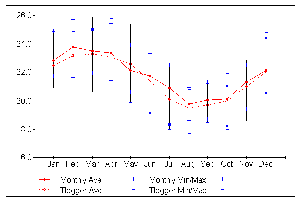
At the Fisheries WA puerulus collection site about 2 km northwest of Rat Island in the Easter Group, some 80 km offshore. Being near the edge of the continental shelf, the site experiences the influence of the warm southward-flowing Leeuwin Current.

Data
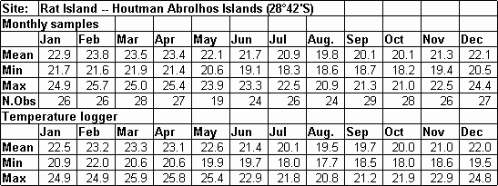
(1) Measured by mercury thermometer on monthly visits to the puerulus collectors; estimated accuracy 0.3°C. Period of data analysis 1970 to 1976 and 1984 to 1995. Sampling is ongoing.

(2) Recorded at 15-minute intervals by a Wesdata Model 389 Temperature Logger mounted in a concrete cradle on the seabed in about 5 m water depth. Rated accuracy 0.1°C. Period of data analysis 1990 to 1994. Sampling is ongoing.

Acknowledgement
Mark Rossbach, Michael Byrne, Jim Christianopoulos, Chris Chubb (Fisheries WA)

Publications
Pearce, A.F., M.Rossbach, M.Tait & R.Brown (1999). Sea temperature variability off Western Australia 1990 to 1994. Fisheries WA Research Report 111: 45pp.

Pearce,A.F. (1997). The Leeuwin Current and the Houtman Abrolhos Islands. In: Wells F. E. (editor), The marine flora and fauna of the Houtman Abrolhos Islands, Western Australia. Proceedings of the 7th International Marine Biology Workshop, Western Australian Museum, Volume 1,11-46.

Regional
Oceanography
| Fisheries | Satellite Remote
Sensing
| Bibliography | Home | Contact

Updated 23rd May 2003 - web@per.marine.csiro.au

Website established Nov 99 by Rabi Rivett and Alan Pearce.
© Copyright 2003, CSIRO Australia.
Use of this web site and information available from it is subject to our
Legal Notice and Disclaimer.