Fact Sheet: Discovering Seamounts
"There is very strong evidence that these seamounts are virtual
islands in a deep ocean where creatures have been effectively marooned
for millions of years and have evolved independently," Dr Tony Koslow,
senior ecologist at CSIRO Marine and Atmospheric Research,
Introduction
Seamounts — extinct submarine volcanoes — are virtual oases
on a comparatively barren sea floor. Orange roughy and oreos swarm in
the water above them and the sea floor may be largely covered by corals
and other species adapted to the strong currents typical of this unique
deep sea environment.
There are an estimated 30,000 undersea mountains in the world, mostly
at depths of 1,500 metres or more.
While comparatively few have been studied, recent international research
initiatives in the Tasman and Coral Seas between Australia and France
have shed considerable light on the world of seamounts and deep ocean
ecosystems.

Mapping by the Australian Geological Survey
Organisation clearly illustrates the layout of seamounts on the
Continental slope, 170 km south of Hobart. |
Seamounts in Australia’s oceans
Interest — and concern — about seamounts, their resources
and their conservation stems back to the 1980’s when substantial
orange roughy fisheries developed in the south-west Pacific around New
Zealand and Australia, primarily on seamounts between 650 metres and
1500 metres in depth.
In the 1990’s, many of Australia’s seamounts — predominantly
found on the slope that descends from the continental shelf to the deep
ocean — were mapped by the Australian Geological Survey Organisation.
Prominent among these are seamounts south of Tasmania, north west of Australia,
and on the Lord Howe Island and Norfolk Island plateaus in the Tasman
and Coral Seas.
The most intensively fished seamounts rise an average height of 400 metres
from the seafloor and are between 650 and 1,000 metres below the sea surface.
Elsewhere, there are much deeper seamounts at between 1150 and 1700 metres
below the sea surface.
[top]
Deep discoveries
Oceanographers, biologists, taxonomists, and geoscientists have been
applying new technologies to evaluate life forms supported by the seamount
ecosystems. Deep ocean video camera systems towed by research vessels
provide the most graphic evidence of life and environmental conditions
at these depths while nets, corers and dredges are deployed to obtain
hard evidence.
Since 1984, French scientists have mounted 24 expeditions to explore
seamounts ridges and the adjacent seafloor along the Lord Howe and Norfolk
Ridges. The French research program involved collaboration with approximately
200 researchers worldwide to identify the little-known seamount fauna.
Australia’s seamount research is based on a 1997 voyage to the seamounts
south of Tasmania on the CSIRO research vessel, Southern Surveyor, and
was funded by Environment Australia and the Fisheries Research and Development
Corporation.
Although the combined French and Australian studies have sampled fewer
than 25 seamounts in the Tasman and Coral Sea region, they uncovered more
than 850 species, 42% more than previously reported from all studies of
seamounts in the past 125 years. Several of the species are ‘living
fossils,’ relict species from groups believed extinct since the Mesozoic,
the time of the dinosaurs.
About a third of these species are new to science and are likely to be
restricted to the seamount environment. Collaboration between French and
Australian researchers has shown very little overlap in the species occurring
on seamounts between one ridge system and another, even those at the same
latitude and separated only by as much as 1000 km.
The unique biological communities on seamounts are dominated by corals
adapted to life in the deep sea, as well as sponges, sea fans and other
organisms that filter their prey from the strong currents.
[top]
The environment
The seamount ecosystem is sustained by food resources carried by passing
currents. Orange roughy, for example, feed on prawns, squid and small
fish that drift past the seamounts or migrate down onto them during the
day. The corals and other creatures on the sea floor consume mostly plankton
that drifts along near the bottom. The system thus draws on food resources
generated ‘upstream’ in the previous weeks or months before
it is swept in among the seamounts, perhaps from hundreds of kilometres
distant. Current speeds in the vicinity of seamounts are greatly enhanced,
similar to accelerating winds on mountain slopes and peaks, as the relatively
slow deepwater currents are forced to pass around these obstructions.
Seamounts in Marine Parks
As a result of this research, Environment Australia has initiated, with
the support of the fishing industry and conservation groups, a range of
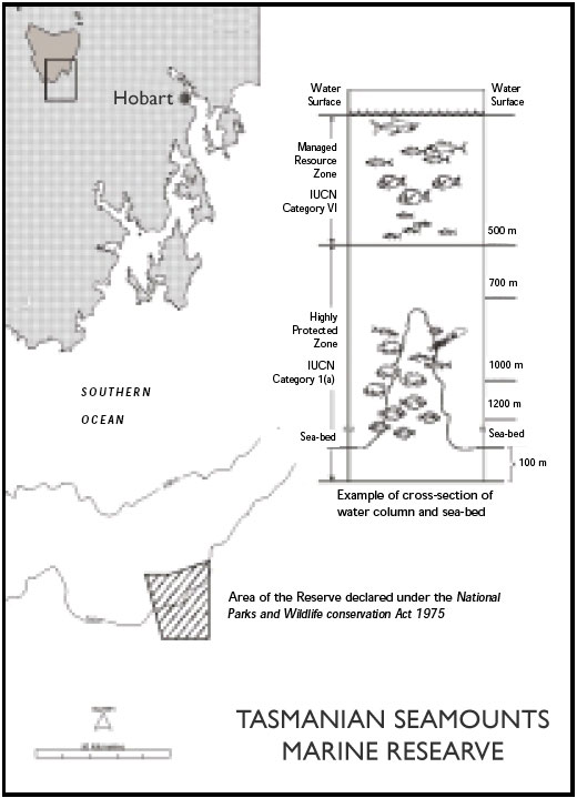
conservation measures on seamounts in Australia’s EEZ.In 1999 Australia
declared its first deep-sea marine reserve on the Continental slope 170
km south of Hobart. The Tasmanian Seamounts Marine Reserve has an area
of about 370 square kilometres. The seamount region off Tasmania is a
distinct geological feature not found elsewhere on the continental margin
of Australia. It includes 70 submerged and extinct volcanoes in water
between 1000 and 2000 metres deep on the continental slope. Some 20 per
cent of the seamounts have been placed within the Reserve. The area of
the Reserve has not been trawled and is therefore in pristine condition.
The seamounts support a distinct benthic (bottom dwelling) community
of animals, many of which are native to the Tasmanian seamounts and do
not occur anywhere else on earth.
The declaration of the reserve by the Australian Government followed
extensive consultations with the community including the fishing industry
and conservation groups. The Reserve is divided into two management zones
—
[top]
Acknowledgements:
CSIRO Marine and Atmospheric Research, Centre IRD de Noumea, Environment Australia
Fisheries Research and Development Corporation, Australian Geological,
Survey Organisation, National Oceans Office, Australian Fisheries Management
Authority, Dr Tony Koslow, CSIRO Marine and Atmospheric Research
Dr Gary Poore, Museum Victoria, Dr Bertrand Richer de Forges, Centre
IRD de Noumea, Marine and Coastal Community Network
Produced September 2000.
[top]
Last modified:
12/11/08

|