Modelling climate
CSIRO Atmospheric Research Greenhouse Information
Paper
What is a climate model?
Climate models are complex, lengthy computer programs based upon the
physical laws and equations of motion that govern the Earth’s climate
system. It takes the most powerful super-computers in the world to carry
out the necessary computations.
Climate models attempt to mimic (or reproduce) the way in which the Earth's
climate behaves from day to day, and also over the seasons (spring, summer,
autumn, winter). They have to do this for all parts of the globe: the
surface, throughout the atmosphere, and for the depths of the oceans.
Quite a task!
What does a climate model contain?
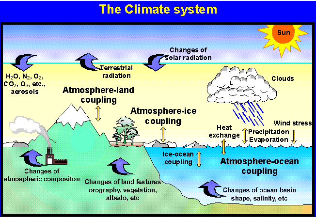
Global climate models contain four main components:
- the atmosphere
- the oceans
- the ice and snow covered regions
- the land surfaces with vegetation cover
- In the real world, all of these components interact with each other
in complicated ways. A climate model is designed to include all of these
interacting parts.
What are climate models used for?
Climate models are primarily used to help us understand how the climate
of the world behaves.
The models are also being used to see if we can predict when major variations
in climate, such as a severe drought over a part of Australia, are going
to occur.
Another important use of climate models is to assess possible global
warming due to increasing levels of carbon dioxide in the atmosphere (the
greenhouse effect). Other uses include testing the climatic effects of
changing land usage such as tropical deforestation.
The CSIRO climate model
There are only a small number of models of the complete climate system
in the world. This is due to the complexity of the work involved. CSIRO’s
climate model is capable of reproducing the world’s average climate,
and has been used in a range of studies.
Today, the CSIRO model is being used to obtain more detailed information
on the climate over Australia by means of a "nested model".
The climate model computes information about climate at points around
the globe set in a grid pattern a few hundred kilometres apart. This is
done throughout the depth of the atmosphere and the oceans, as well as
at the surface.
The nested model is very similar to the global model except that it has
much closer spaced points over a limited region, say, Australia. Information
from the global climate model drives the nested model, providing far more
detailed information about the climate over a particular region. This
can be very useful for investigating the cause of local climatic patterns,
such as rainfall occurrence.
Hal Gordon
October, 1996
|