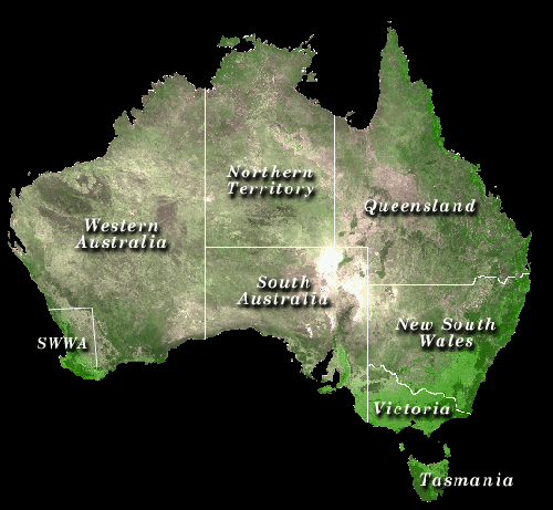
Australian rainfall trendsParts of Australia have become wetter, with more days of rain (raindays) and increases in heavy rainfall amounts. This is the conclusion of a study of daily rainfall at over 300 Australian sites from 1910 to 1995 by Hennessy et al. (1999) using data from the Bureau of Meteorology. See a map of rainfall stations used in this study. Choose your area of interest by clicking on the map below, or select all of Australia. (Check the necessary computer requirements here).
GlossarySummary of regional trendsAnnual total rainfall has risen by about 15% in New South Wales, South Australia, Victoria and the Northern Territory, with little change in the other states. South-west Western Australia has become 25% drier in winter, largely due to a decline between 1960 and 1972. There has also been a significant 10% rise in the Australian-average number of raindays. The Northern Territory and New South Wales have experienced the greatest increase in raindays, while Tasmania and south-west Western Australia now have fewer raindays than in the past. One of the most interesting findings is an increase in heavy rainfall, defined as the 99th percentile of daily rainfall - this is the largest daily rainfall amount in each season, or the 4th largest daily rainfall amount each year. Increases of 10-45% were found in many regions but few were statistically significant. Significant increases in heavy rainfall of 20-30% have occurred in New South Wales in autumn and summer, in the Northern Territory in autumn, and in Western Australia in summer. South-west Western Australia experienced a 15% decrease in heavy rainfall in winter. Following the sequence of wet La Niña years during 1973-75, there has been a tendency for more El Niños than La Niñas up to 1995. El Niños are normally associated with relatively dry conditions in Australia, but since 1975 annual rainfall shows:
See diagrams of annual total rainfall from 1900-1998 in north-west, north-east, south-west and south-east Australia (produced by the Bureau of Meteorology’s National Climate Centre). Many climate models indicate that global warming may lead to more storms. Although the observations over Australia during the past century are consistent with the model results, there may be other factors causing the observed changes, such as land-use change, burning of vegetation, ozone depletion, sunspot activity and long-term natural variability. ReferenceHennessy, K.J., Suppiah, R. and Page, C.M. (1999): Australian rainfall changes, 1910-1995. Aust. Met. Mag. 48, 1-13. For more information please contact: Kevin Hennessy, Ph: +61 3 9239 4536; Fax: +61 3 9239 4444; E-mail: kevin.hennessy@csiro.au This work is a contribution of the Climate Impact Group to CSIRO's Climate Change Research Program. The Australian rainfall trends pages require a full implementation of the java libraries. We recommend that you view them with Microsoft Internet Explorer 4.0. or Netscape Navigator 4.5x. It will not run on earlier versions or other browsers that do not implement the full suite of java routines. |
|
|
Modified: April 3, 2008 |
