Voyage details and related metadata, reports, events and data.
SS2013_V06
- is a Marine National Facility ![]() voyage
voyage
Period: 2013-10-05 21:00 to 2013-10-16 21:00 UTC
Duration: 11.00 days
From: Hobart To: Hobart
Region: Southern Ocean-Indian sector. Subantarctic Zone southwest of Tasmania
Ship: Southern Surveyor [details]
Description: MNF Southern Surveyor research voyage SS2013_v06. Integrated Marine Observing System (IMOS) Facility 3. Southern Ocean Time Series (SOTS) moorings for climate and carbon cycle studies southwest of Tasmania (47ºS, 140º E). Scientific Objectives: The overall scientific objective is to obtain frequent measurements of surface and deep ocean properties that control the transfer of CO2 from the atmosphere to the upper ocean, and then onwards to the ocean interior in the form of sinking particles. This "biological pump" drives carbon sequestration from the atmosphere, and writes the sedimentary record. The controls on its intensity are complex and involve processes that vary on daily, weekly, seasonal, and inter-annual timescales. Obtaining observations with the necessary frequency is not possible from ships. For this reason the IMOS Southern Ocean Time Series Facility seeks to obtain this information using automated sensor measurements and sample collections. Recovery and Deployments: Recovery of: SOFS-4 mooring, Pulse-10 mooring, SAZ-15 mooring. Ancillary work includes underway and CTD sensor measurements and sample collections, and potentially zooplankton net sampling and towing of a continuous plankton recorder (CPR).
Leader: E. Schulz (BOM)
Project: SOTS: Southern Ocean Time Series automated moorings for climate and carbon cycle studies southwest of Tasmania [details]
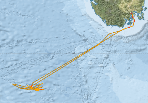
Voyage extents: 46° 57.9' S to 42° 53.0' S 141° 04.7' E to 147° 30.0' E Get voyage track shapefile Get CSV
Marlin Metadata:-
Participants - on ship:-
| Name | Role | Organisation |
|---|---|---|
| Don McKenzie | MNF Voyage Manager | CSIRO Marine and Atmospheric Research |
| Eric Schulz | Moorings, meteor. | Bureau of Meteorology |
| Mark Lewis | Moorings | CSIRO Marine and Atmospheric Research |
| Max McGuire | MNF Observer | CSIRO Marine and Atmospheric Research |
| Nicole Morgan | MNF Electronics support | CSIRO Marine and Atmospheric Research |
| Pamela Brodie | MNF Computing support / Deputy Voyage Manager | CSIRO Marine and Atmospheric Research |
| Peter Dunne | MNF Electronics support | CSIRO Marine and Atmospheric Research |
| Peter Jansen | Moorings, electronics | Antarctic Cooperative Research Centre |
| Stephen Bray | Moorings, sediment traps | Antarctic Cooperative Research Centre |
| Tegan Sime | MNF Observer | CSIRO Marine and Atmospheric Research |
This list includes those that may have only been on part of the voyage. See voyage reports on 'Reports and Maps' tab for details.
Marine National Facility Reports - plans, summaries and data processing
-
SS2013_V06 Scientific Highlight
- report of the key outputs
-
SS2013_V06 Underway Data Processing Report
- details of data processing steps, calibration information, instruments used and any issues with the data.
-
SS2013_V06 Voyage Summary
- includes preliminary results, voyage narrative, types of data collected with C77/ROSCOP codes.
-
SS2013_V06 Voyage Plan
- includes objectives, investigator details, proposed data collection, voyage track and equipment to be used.
-

Publications, reports and datasets from this voyage.
Dataset
- Bakker, Dorothee C E; Pfeil, Benjamin; Smith, Karl; Hankin, Steven; Olsen, Are; Alin, Simone R; Cosca, Catherine E; Harasawa, Sumiko; Kozyr, Alexander; Nojiri, Yukihiro; O'Brien, Kevin M; Schuster, Ute; Telszewski, Maciej; Tilbrook, Bronte; Wada, Chisato; Akl, John; Barbero, Leticia; Bates, Nicolas R; Boutin, Jacqueline; Bozec, Yann; Cai, Wei-Jun; Castle, Robert D; Chavez, Francisco P; Chen, Lei; Chierici, Melissa; Currie, Kim I; de Baar, Hein J W; Evans, Wiley; Feely, Richard A; Fransson, Agneta; Gao, Zhongyong; Hales, Burke; Hardman-Mountford, Nicolas J; Hoppema, Mario; Huang, Wei-Jen; Hunt, Christopher W; Huss, Betty; Ichikawa, Tadafumi; Johannessen, Truls; Jones, Elizabeth M; Jones, Steve D; Jutterstrøm, Sara; Kitidis, Vassilis; Körtzinger, Arne; Landschützer, Peter; Lauvset, Siv K; Lefèvre, Nathalie; Manke, Ansley; Mathis, Jeremy T; Merlivat, Liliane; Metzl, Nicolas; Murata, Akihiko; Newberger, Timothy; Omar, Abdirahman M; Ono, Tsuneo; Park, Geun-Ha; Paterson, Kristina; Pierrot, Denis; Ríos, Aida F; Sabine, Christopher L; Saito, Shu; Salisbury, Joe; Sarma, Vedula V S S; Schlitzer, Reiner; Sieger, Rainer; Skjelvan, Ingunn; Steinhoff, Tobias; Sullivan, Kevin; Sun, Heng; Sutton, Adrienne; Suzuki, Toru; Sweeney, Colm; Takahashi, Taro; Tjiputra, Jerry; Tsurushima, Nobuo; van Heuven, Steven; Vandemark, Doug; Vlahos, Penny; Wallace, Douglas WR; Wanninkhof, Rik; Watson, Andrew J (2014): Surface Ocean CO2 Atlas (SOCAT) V2. PANGAEA, 10.1594/PANGAEA.811776
- Smith, S. R.,Lopez, N.,Bourassa, M. A. (2016) SAMOS air‐sea fluxes: 2005–2014. Geoscience Data Journal 3 pp9-19. 10.1002/gdj3.34
Journal Article
- Rapizo H., A. V. Babanin , E. Schulz , M. Hemer, and T. Durrant (2015) Observation of wind-waves from a floating buoy in the Southern Ocean, Ocean Dynamics, 75 (9), 1275-1288, 10.1007/s10236-015-0873-3
- Shadwick, E. H., T. W. Trull, B. Tilbrook, A. J. Sutton, E. Schulz, and C. L. Sabine (2015) Seasonality of biological and physical controls on surface ocean CO2 from hourly observations at the Southern Ocean Time Series site south of Australia, Global Biogeochemical Cycles, 29, 223-238, 10.1002/2014GB004906
- Traill, Christopher D.,Rohr, Tyler,Shadwick, Elizabeth,Schallenberg, Christina,Ellwood, Michael,Bowie, Andrew (2025) Coupling Between the Subantarctic Seasonal Iron Cycle and Productivity at the Southern Ocean Time Series (SOTS). AGU Advances 6 pp-. 10.1029/2024av001599
- Yang, Xiang,Wynn‐Edwards, Cathryn A.,Strutton, Peter G.,Shadwick, Elizabeth H. (2024) Carbon Export in the Subantarctic Zone Revealed by Multi‐Year Observations From Biogeochemical‐Argo Floats and Sediment Traps. Global Biogeochemical Cycles 38 pp-. 10.1029/2024GB008135
Search for publications, reports and datasets from this and other voyages
Data publishing
This is a list of online datasets hosted by CSIRO. Other processed datasets hosted by collaborating organisations may be found on the 'Metadata' or "Reports, Publications and Maps' tab.
Use the Get data link on the right to extract data using the NCMI Data Trawler.
| Data Stream | Data Summary | Get data | ||||||||||||||
|---|---|---|---|---|---|---|---|---|---|---|---|---|---|---|---|---|
| ADCP Data |
|
Get Data from Trawler Download NetCDF ss2013_v06_ADCP_nc.zip Download Processing Report ss2013_v06ADCP.pdf Overview ADCP Dataset HTML |
||||||||||||||
| CTD profile |
|
Get Data from Trawler Download NetCDF data ss2013_v06_CTD_avg_nc.zip Download Processing report ss2013_v06CTD.pdf Download CTD plots ss2013_v06_CTD_plots_png.zip |
||||||||||||||
| Hydrology |
|
Get Data from Trawler Download CSV format - ss2013_v06_HYD_csv.zip Download Processing report Download NetCDF format - ss2013_v06_HYD_nc.zip |
||||||||||||||
| Multibeam echosounder |
|
Get Data from Trawler |
||||||||||||||
| SOOP Bio-acoustics |
|
External link
Transect 2 - datafile at IMOS NetCDF Data Format: Manual Download |
||||||||||||||
| Underway |
|
Get Data from Trawler Download 5 sec NetCDF dataset ss2013_v06UWYnc.zip |
Deployments by start time:- Click on column header to sort. Use link on 'Deployment' to see full details. Use the CSV button at the bottom to export data (tab delimited).
Search for deployments from this voyage and others
| Deployment | Operation | Station | Cast | Gear | Project | Start and end times | Start Location | End Location | Depth range | Max Depth | Description | |||
|---|---|---|---|---|---|---|---|---|---|---|---|---|---|---|
| Underway System [details] | Air Temperature Sensor-HMP230,Barometer,Doppler speed log,Fluorometer WS3S-443P,Gill Ultrasonic Wind Sensor,Gill Ultrasonic Wind Sensor,Humidity Sensor-HMP230,IMOS Port Pyranometer-SN 35122F3,IMOS Port Radiometer-SN 35111F3,IMOS Stbd Pyranometer-SN 35123F3,IMOS Stbd Radiometer-SN 35093F3,IMOS rain gauge,IMOS rain gauge,Licor - LI-190SL Q46072,RM Young 05106 wind monitor-75621,RM Young 05106 wind monitor-75621,RM Young 05106 wind monitor-75621,RM Young Rain Gauge,Seapath 200,Seapath 200,Seapath 200,Simrad EK60 echosounder,ThermoSalinoGraph (TSG)-SN 2753,ThermoSalinoGraph (TSG)-SN 2753 | 2365 | 2013-10-06 21:03 | 2013-10-16 21:26 | -42.8863 | 147.3386 | -42.8864 | 147.3386 | ||||||
| Multibeam echosounder [details] | EM300 Multibeam Echosounder | 2013-10-06 22:27 | 2013-10-16 18:28 | -43.0867 | 147.4059 | -42.9604 | 147.3758 | 4319.5 | ||||||
| ADCP Data [details] | RDI Ocean Surveyor Acoustic Doppler current profiler | 2365 | 2013-10-06 23:44 | 2013-10-16 16:09 | -43.2974 | 147.4863 | -43.1558 | 147.4483 | 813.5 | |||||
| CTD Cast [details] | 1 | Cast 1 | CTD 21,Conductivity CTD 21 - SN 3309,Fluorometer-CTD 21 -Chelsea-06-5941-001,Licor - CTD 21 - SN 70371,Oxygen-CTD 21-SBE 43-SN 1239,Pressure CTD 21,Temperature CTD 21 - SN 5422,Transmissometer - CTD 22 -CST-1421DR | 2365 | 2013-10-07 03:16 | 2013-10-07 03:31 | -43.6277 | 147.2130 | -43.6283 | 147.2134 | 79 | |||
| CTD Cast / Hydrology [details] | 2 | Cast 2 | CTD 21,Conductivity CTD 21 - SN 3309,Fluorometer-CTD 21 -Chelsea-06-5941-001,Licor - CTD 21 - SN 70371,Oxygen-CTD 21-SBE 43-SN 1239,Pressure CTD 21,Temperature CTD 21 - SN 5422,Transmissometer - CTD 22 -CST-1421DR | 2365 | 2013-10-14 05:32 | 2013-10-14 06:32 | -46.9140 | 142.5983 | -46.9139 | 142.5983 | 1001.2 | |||
| CTD Cast / Hydrology [details] | 3 | Cast 3 | CTD 21,Conductivity CTD 21 - SN 3309,Fluorometer-CTD 21 -Chelsea-06-5941-001,Licor - CTD 21 - SN 70371,Oxygen-CTD 21-SBE 43-SN 1239,Pressure CTD 21,Temperature CTD 21 - SN 5422,Transmissometer - CTD 22 -CST-1421DR | 2365 | 2013-10-15 04:20 | 2013-10-15 05:14 | -46.7316 | 142.0912 | -46.7336 | 142.0919 | 1002.8 | |||