Voyage details and related metadata, reports, events and data.
SS 03/2008
(alternative identifier: SS200803)
- is a Marine National Facility ![]() voyage
voyage
Period: 2008-02-28 00:00 to 2008-03-17 00:00 UTC
Duration: 18.00 days
From: Port Adelaide To: Hobart
Region: Great Australian Bight; South Australian and Tasmanian continental slope
Ship: Southern Surveyor [details]
Description:
Title: "Estimating the effectiveness of spatial closures for deepwater gulper sharks and associated fishery species"
Scientific Objectives
Areas of seabed in Commonwealth waters off temperate Australia are being closed to fishing as marine reserves are developed by the DEHA, and as spatial closures are increasingly used by AFMA to manage fishery stocks. One current focus for both conservation and fishery closures is the protection of gulper sharks which are under consideration for endangered species listing. Other species and habitats................
Voyage Objectives
1. Map and characterize the benthic ecosystem of the 60-mile closure in the GAB using the EM300 multibeam and quantitative towed camera surveys
2. Quantify the abundance of gulper sharks and associated species, inside and outside the closure by non-extractive quantitative towed camera surveys.
3. Estimate species relative abundances inside and outside the 60-mile closure using non-extractive underwater baited video cameras (BRUVs).
4. Assess the survivorship by gulper sharks and other species following tagging. This will use a specially designed trap with (1) a surveillance camera to monitor behaviour during descent, on the bottom, and during ascent, and (2) an acoustic receiver to track fish movements away from the trap after release.
5. Evaluate movement in and out of the 60-mile closure using two curtains of acoustic VR2 listening stations to detect fish tagged with acoustic V16 tags.
6. Acquire additional deepwater camera calibration data with scalebar and rotating 16-laser array......
Taken from SS200803 Voyage Plan (see link above).
Leader: A. Williams (CSIRO/DEH)
Project: Determining the ecological basis for spatial management of deep water fishes with a focus on pink ling, gulper sharks and ribaldo [details]
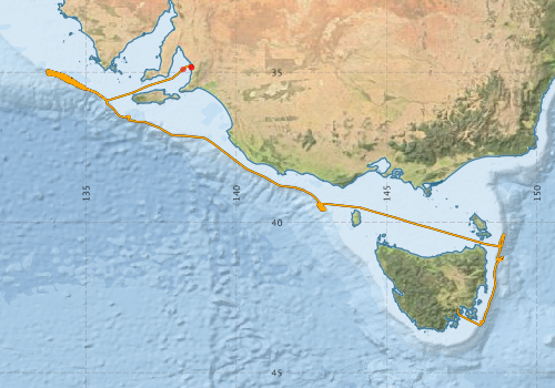
Voyage extents: 43° 25.8' S to 34° 45.7' S 133° 40.1' E to 148° 55.2' E Get voyage track shapefile Get CSV
Marlin Metadata:-
Metadata from OBIS Australia datasets:- biological data is published via the OBIS-AU IPT server and delivered to one or more of OBIS, ALA and GBIF
Download from OBIS Australia IPT View at - Ocean Biodiversity Information System (OBIS) Atlas of Living Australia (ALA) GBIF
Download from OBIS Australia IPT View at - Ocean Biodiversity Information System (OBIS) Atlas of Living Australia (ALA) GBIF
Download from OBIS Australia IPT View at - Ocean Biodiversity Information System (OBIS) Atlas of Living Australia (ALA) GBIF
Download from OBIS Australia IPT View at - Ocean Biodiversity Information System (OBIS)
Participants - on ship:-
| Name | Role | Organisation |
|---|---|---|
| Alan Williams | Chief Scientist | CSIRO Oceans & Atmosphere - Hobart |
| Bruce Barker | Watch Leader/ Camera systems | CSIRO Oceans & Atmosphere - Hobart |
| Jeff Cordell | Camera systems | CSIRO Oceans & Atmosphere - Hobart |
| Karen Gowlett-Holmes | Invertebrate biology | CSIRO Oceans & Atmosphere - Hobart |
| Karl Forcey | NF electronics support | CSIRO Oceans & Atmosphere - Hobart |
| Mark Green | Tagging & vessel coordination | CSIRO Oceans & Atmosphere - Hobart |
| Mark Lewis | Gear operations | CSIRO Oceans & Atmosphere - Hobart |
| Matt Sherlock | Camera electronics | CSIRO Oceans & Atmosphere - Hobart |
| Pamela Brodie | NF Computing | CSIRO Oceans & Atmosphere - Hobart |
| Rick Smith | NF Swath mapping | CSIRO Oceans & Atmosphere - Hobart |
| Ross Daley | Shark biology & tagging | CSIRO Oceans & Atmosphere - Hobart |
| Tony Smith | Data synthesis | CSIRO Oceans & Atmosphere - Hobart |
This list includes those that may have only been on part of the voyage. See voyage reports on 'Reports and Maps' tab for details.
Marine National Facility Reports - plans, summaries and data processing
-
SS200803 Voyage Plan
- includes objectives, investigator details, proposed data collection, voyage track and equipment to be used.
-
SS200803 Underway Data Processing Report
- details of data processing steps, calibration information, instruments used and any issues with the data.
-
SS200803 Voyage Summary
- includes preliminary results, voyage narrative, types of data collected with C77/ROSCOP codes.
-
SS200803 Scientific Highlight
- report of the key outputs
-

Publications, reports and datasets from this voyage.
Dataset
- Bakker, Dorothee C E; Pfeil, Benjamin; Smith, Karl; Hankin, Steven; Olsen, Are; Alin, Simone R; Cosca, Catherine E; Harasawa, Sumiko; Kozyr, Alexander; Nojiri, Yukihiro; O'Brien, Kevin M; Schuster, Ute; Telszewski, Maciej; Tilbrook, Bronte; Wada, Chisato; Akl, John; Barbero, Leticia; Bates, Nicolas R; Boutin, Jacqueline; Bozec, Yann; Cai, Wei-Jun; Castle, Robert D; Chavez, Francisco P; Chen, Lei; Chierici, Melissa; Currie, Kim I; de Baar, Hein J W; Evans, Wiley; Feely, Richard A; Fransson, Agneta; Gao, Zhongyong; Hales, Burke; Hardman-Mountford, Nicolas J; Hoppema, Mario; Huang, Wei-Jen; Hunt, Christopher W; Huss, Betty; Ichikawa, Tadafumi; Johannessen, Truls; Jones, Elizabeth M; Jones, Steve D; Jutterstrøm, Sara; Kitidis, Vassilis; Körtzinger, Arne; Landschützer, Peter; Lauvset, Siv K; Lefèvre, Nathalie; Manke, Ansley; Mathis, Jeremy T; Merlivat, Liliane; Metzl, Nicolas; Murata, Akihiko; Newberger, Timothy; Omar, Abdirahman M; Ono, Tsuneo; Park, Geun-Ha; Paterson, Kristina; Pierrot, Denis; Ríos, Aida F; Sabine, Christopher L; Saito, Shu; Salisbury, Joe; Sarma, Vedula V S S; Schlitzer, Reiner; Sieger, Rainer; Skjelvan, Ingunn; Steinhoff, Tobias; Sullivan, Kevin; Sun, Heng; Sutton, Adrienne; Suzuki, Toru; Sweeney, Colm; Takahashi, Taro; Tjiputra, Jerry; Tsurushima, Nobuo; van Heuven, Steven; Vandemark, Doug; Vlahos, Penny; Wallace, Douglas WR; Wanninkhof, Rik; Watson, Andrew J (2014): Surface Ocean CO2 Atlas (SOCAT) V2. PANGAEA, 10.1594/PANGAEA.811776
IPT Resource
- Australian National Fish Collection (ANFC) (Darwin Core Archive) External link to reference
- CSIRO Marine Invertebrate Image Collection (MIIC) (Darwin Core Archive) External link to reference
- CSIRO, Cruise SS200803, Marine Biological Survey, Great Australian Bight; South Australian and Tasmanian continental slope, 2008 (Darwin Core Archive) External link to reference
- Global benthic biogeographical regions and macroecological drivers for ophiuroids [Data set] (Darwin Core Archive) External link to reference
Journal Article
- O'Hara, T. D. and Harding, C. (2014) A new species of Sigsbeia and additional records of ophiuroids from the Great Australian Bight. Memoirs of Museum of Victoria 72 131-140 10.24199/j.mmv.2014.72.08
- Waite, Anya M.,Raes, Eric,Beckley, Lynnath E.,Thompson, Peter A.,Griffin, David,Saunders, Megan,Säwström, Christin,O'Rorke, Richard,Wang, Miao,Landrum, Jason P. (2019) Production and ecosystem structure in cold-core vs. warm-core eddies: Implications for the zooplankton isoscape and rock lobster larvae. Limnology and Oceanography 64 pp2405-2423. 10.1002/lno.11192
Search for publications, reports and datasets from this and other voyages
Data publishing
This is a list of online datasets hosted by CSIRO. Other processed datasets hosted by collaborating organisations may be found on the 'Metadata' or "Reports, Publications and Maps' tab.
Use the Get data link on the right to extract data using the NCMI Data Trawler.
| Data Stream | Data Summary | Get data | ||||||||||||||
|---|---|---|---|---|---|---|---|---|---|---|---|---|---|---|---|---|
| ADCP Data |
|
Get Data from Trawler Download netCDF dataset ss200803ADCP_nc.zip Processing report for this dataset - SS200803_UWY_ADCP_Report.pdf |
||||||||||||||
| Marine biodiversity observations and/or samples |
|
Get Data from Trawler |
||||||||||||||
| Multibeam echosounder |
|
Get Data from Trawler |
||||||||||||||
| pCO2 |
|
External link - download datafile at IMOS |
||||||||||||||
| Underway |
|
Get Data from Trawler Download NetCDF dataset ss200803UWYnc.zip (Note TSG high) |
Deployments by start time:- Click on column header to sort. Use link on 'Deployment' to see full details. Use the CSV button at the bottom to export data (tab delimited).
Search for deployments from this voyage and others
| Deployment | Operation | Station | Cast | Gear | Project | Start and end times | Start Location | End Location | Depth | Description | |||
|---|---|---|---|---|---|---|---|---|---|---|---|---|---|
| Underway System [details] | Air Temperature Sensor-HMP233,Barometer,Fluorometer WS3S-443P,Humidity Sensor-HMP233,Licor-UWQ 3708,RM Young 05106 wind monitor-75621,RM Young 05106 wind monitor-75621,RM Young 05106 wind monitor-75621,RM Young 05106 wind monitor-75621,RM Young Rain Gauge,Remote Temperature (T)-SN 2621,Seapath 200,Seapath 200,Seapath 200,Simrad EA500 Echosounder,ThermoSalinoGraph (TSG)-SS-SN 1777 | 2190 | 2008-02-28 00:45 | 2008-03-17 04:04 | -34.8372 | 138.5096 | -42.8863 | 147.3385 | |||||
| Multibeam echosounder [details] | EM300 Multibeam Echosounder | 2008-02-28 01:35 | 2008-03-17 03:02 | -34.8372 | 138.5096 | -42.9688 | 147.3544 | 1980.8 | |||||
| ADCP Data [details] | RDI Ocean Surveyor Acoustic Doppler current profiler | 2190 | 2008-02-28 04:02 | 2008-03-17 01:26 | -34.9028 | 138.2327 | -43.1105 | 147.4850 | 639 | ||||
| Video [details] | 2 | Shallow Video System | 2008-02-29 22:50 | 2008-02-29 23:55 | -35.1408 | 134.3554 | -35.1588 | 134.3863 | |||||
| Video [details] | 3 | Shallow Video System | 2008-03-01 00:08 | 2008-03-01 01:05 | -35.1622 | 134.3924 | -35.1779 | 134.4290 | |||||
| Video [details] | 4 | Shallow Video System | 2008-03-01 03:06 | 2008-03-01 04:36 | -35.2119 | 134.4251 | -35.2334 | 134.4620 | |||||
| Video [details] | 7 | Shallow Video System | 2008-03-01 17:26 | 2008-03-01 18:45 | -35.3886 | 134.7304 | -35.4276 | 134.7158 | |||||
| Video [details] | 8 | Shallow Video System | 2008-03-01 19:53 | 2008-03-01 21:06 | -35.3127 | 134.6244 | -35.3412 | 134.5883 | |||||
| Video [details] | 9 | Shallow Video System | 2008-03-01 21:58 | 2008-03-01 23:26 | -35.2940 | 134.6031 | -35.2962 | 134.5473 | |||||
| Video [details] | 10 | Shallow Video System | 2008-03-01 23:55 | 2008-03-02 01:10 | -35.2574 | 134.5487 | -35.2881 | 134.5151 | |||||
| Photos [details] | 11 | Photosea 1000 Camera | 2008-03-02 07:19 | 2008-03-02 07:35 | -35.1465 | 134.2989 | -35.1450 | 134.2968 | |||||
| Photos [details] | 12 | Photosea 1000 Camera | 2008-03-02 07:36 | -35.1447 | 134.2965 | ||||||||
| Photos [details] | 13 | 2008-03-02 08:07 | -35.1381 | 134.2983 | |||||||||
| Photos [details] | 14 | Photosea 1000 Camera | 2008-03-02 08:40 | -35.1529 | 134.3074 | ||||||||
| Video [details] | 15 | Shallow Video System | 2008-03-02 16:47 | 2008-03-02 18:27 | -35.1379 | 134.3307 | -35.1806 | 134.2920 | |||||
| Video [details] | 16 | Shallow Video System | 2008-03-02 19:13 | 2008-03-02 20:14 | -35.1403 | 134.2675 | -35.1732 | 134.2804 | |||||
| Video [details] | 17 | Shallow Video System | 2008-03-02 21:19 | -35.1986 | 134.4348 | ||||||||
| CTD Cast [details] | 18 | Cast | CTD (Southern Surveyor) | 2008-03-02 23:17 | 2008-03-02 23:40 | -35.2180 | 134.4312 | -35.2197 | 134.4312 | ||||
| Video [details] | 20 | Shallow Video System | 2008-03-03 01:11 | -35.1988 | 134.4356 | ||||||||
| Photos [details] | 22 | Photosea 1000 Camera | 2008-03-03 06:15 | -35.2205 | 134.4324 | ||||||||
| Photos [details] | 23 | 2008-03-03 06:38 | -35.2173 | 134.4304 | |||||||||
| Photos [details] | 24 | Photosea 1000 Camera | 2008-03-03 06:56 | -35.2140 | 134.4280 | ||||||||
| Photos [details] | 25 | 2008-03-03 07:17 | -35.2108 | 134.4261 | |||||||||
| Photos [details] | 26 | Photosea 1000 Camera | 2008-03-03 08:00 | -35.2185 | 134.4374 | ||||||||
| Photos [details] | 27 | Photosea 1000 Camera | 2008-03-03 08:33 | -35.2164 | 134.4351 | ||||||||
| CTD Cast [details] | 28 | Cast | CTD (Southern Surveyor) | 2008-03-03 20:41 | 2008-03-03 20:54 | -35.1888 | 134.4448 | -35.1877 | 134.4454 | ||||
| CTD Cast [details] | 29 | Cast | CTD (Southern Surveyor) | 2008-03-03 21:16 | 2008-03-03 21:38 | -35.1870 | 134.4309 | ||||||
| CTD Cast [details] | 30 | Cast | CTD (Southern Surveyor) | 2008-03-03 22:39 | 2008-03-03 23:11 | -35.2102 | 134.4507 | -35.2101 | 134.4499 | ||||
| CTD Cast [details] | 31 | Cast | CTD (Southern Surveyor) | 2008-03-03 23:32 | 2008-03-04 00:05 | -35.2214 | 134.4425 | ||||||
| CTD Cast [details] | 32 | Cast | CTD (Southern Surveyor) | 2008-03-04 02:34 | 2008-03-04 03:06 | -35.2221 | 134.4427 | -35.2215 | 134.4423 | ||||
| Photos [details] | 33 | Photosea 1000 Camera | 2008-03-04 04:15 | -35.2858 | 134.5630 | ||||||||
| Photos [details] | 34 | Photosea 1000 Camera | 2008-03-04 04:42 | -35.2817 | 134.5611 | ||||||||
| Photos [details] | 35 | Photosea 1000 Camera | 2008-03-04 05:38 | -35.2889 | 134.5729 | ||||||||
| Photos [details] | 36 | Photosea 1000 Camera | 2008-03-04 05:54 | -35.2837 | 134.5762 | ||||||||
| Photos [details] | 37 | Photosea 1000 Camera | 2008-03-04 06:28 | -35.2798 | 134.5728 | ||||||||
| Catch [details] | 38 | CTD (Southern Surveyor) | 2008-03-04 10:40 | -35.2945 | 134.5788 | ||||||||
| Catch [details] | 39 | Smith-McIntyre Grab 0.1cu.m. | 2008-03-04 10:55 | -35.2949 | 134.5778 | ||||||||
| Catch [details] | 47 | Smith-McIntyre Grab 0.1cu.m. | 2008-03-05 12:02 | -35.2094 | 134.4507 | ||||||||
| Catch [details] | 48 | Smith-McIntyre Grab 0.1cu.m. | 2008-03-05 12:30 | -35.2089 | 134.4508 | ||||||||
| Catch [details] | 49 | Smith-McIntyre Grab 0.1cu.m. | 2008-03-05 12:43 | -35.2096 | 134.4510 | ||||||||
| Catch [details] | 50 | Smith-McIntyre Grab 0.1cu.m. | 2008-03-05 13:22 | -35.2214 | 134.4416 | ||||||||
| Catch [details] | 51 | 2008-03-05 13:46 | -35.2216 | 134.4416 | |||||||||
| CTD Cast [details] | 52 | Cast | CTD (Southern Surveyor) | 2008-03-05 17:33 | 2008-03-05 18:39 | -35.2725 | 134.4397 | -35.2721 | 134.4386 | ||||
| CTD Cast [details] | 53 | Cast | CTD (Southern Surveyor) | 2008-03-05 19:02 | 2008-03-05 19:59 | -35.2673 | 134.4258 | -35.2672 | 134.4269 | ||||
| CTD Cast [details] | 54 | Cast | CTD (Southern Surveyor) | 2008-03-05 20:20 | 2008-03-05 21:15 | -35.2495 | 134.4386 | -35.2462 | 134.4383 | ||||
| Photos [details] | 64 | Photosea 1000 Camera | 2008-03-06 04:53 | -35.1786 | 134.3753 | ||||||||
| Photos [details] | 65 | Photosea 1000 Camera | 2008-03-06 05:00 | -35.1779 | 134.3744 | ||||||||
| Photos [details] | 66 | Photosea 1000 Camera | 2008-03-06 05:40 | -35.1691 | 134.3686 | ||||||||
| Photos [details] | 67 | Photosea 1000 Camera | 2008-03-06 05:56 | -35.1663 | 134.3661 | ||||||||
| Photos [details] | 68 | 2008-03-06 06:13 | -35.1625 | 134.3636 | |||||||||
| Catch [details] | 69 | Benthic sled | 2008-03-06 10:57 | 2008-03-06 11:53 | -35.1378 | 134.2734 | -35.1657 | 134.2852 | |||||
| Video [details] | 70 | Shallow Video System | 2008-03-06 16:45 | 2008-03-06 17:37 | -35.0437 | 133.9128 | -35.0463 | 133.9386 | |||||
| Video [details] | 71 | Shallow Video System | 2008-03-06 18:10 | 2008-03-06 18:50 | -35.0550 | 133.9591 | -35.0676 | 133.9816 | |||||
| CTD Cast [details] | 75 | Cast | CTD (Southern Surveyor) | 2008-03-07 00:39 | 2008-03-07 01:10 | -35.2093 | 134.4489 | -35.2095 | 134.4491 | ||||
| CTD Cast [details] | 76 | Cast | CTD (Southern Surveyor) | 2008-03-07 01:50 | 2008-03-07 02:22 | -35.2205 | 134.4419 | -35.2199 | 134.4417 | ||||
| Photos [details] | 77 | Photosea 1000 Camera | 2008-03-07 04:48 | -35.2389 | 134.5074 | ||||||||
| Photos [details] | 78 | Photosea 1000 Camera | 2008-03-07 05:19 | -35.2342 | 134.5028 | ||||||||
| Photos [details] | 79 | Photosea 1000 Camera | 2008-03-07 05:22 | -35.2333 | 134.5014 | ||||||||
| Photos [details] | 80 | Photosea 1000 Camera | 2008-03-07 05:57 | -35.2285 | 134.4959 | ||||||||
| Photos [details] | 81 | Photosea 1000 Camera | 2008-03-07 06:18 | -35.2251 | 134.4912 | ||||||||
| Catch [details] | 82 | Benthic sled | 2008-03-07 10:46 | 2008-03-07 14:19 | -35.2948 | 134.6040 | -35.1831 | 134.1403 | |||||
| Video [details] | 83 | Shallow Video System | 2008-03-07 16:10 | 2008-03-07 17:17 | -35.0478 | 133.9079 | -35.0153 | 133.9084 | |||||
| Video [details] | 84 | Shallow Video System | 2008-03-07 18:05 | 2008-03-07 18:55 | -35.0470 | 133.9170 | -35.0211 | 133.9234 | |||||
| Video [details] | 85 | Shallow Video System | 2008-03-07 20:31 | 2008-03-07 21:53 | -35.0843 | 134.1236 | -35.1251 | 134.0996 | |||||
| Catch [details] | 87 | Smith-McIntyre Grab 0.1cu.m. | 2008-03-08 11:25 | 2008-03-08 11:44 | -35.2035 | 134.4314 | -35.2028 | 134.4326 | |||||
| Catch [details] | 88 | Smith-McIntyre Grab 0.1cu.m. | 2008-03-08 11:45 | -35.2028 | 134.4327 | ||||||||
| Catch [details] | 89 | Smith-McIntyre Grab 0.1cu.m. | 2008-03-08 12:08 | -35.2113 | 134.4388 | ||||||||
| Catch [details] | 90 | Smith-McIntyre Grab 0.1cu.m. | 2008-03-08 12:25 | -35.2118 | 134.4390 | ||||||||
| CTD Cast [details] | 92 | Cast | CTD (Southern Surveyor) | 2008-03-08 17:29 | 2008-03-08 18:20 | -35.2487 | 134.4468 | -35.2496 | 134.4480 | ||||
| CTD Cast [details] | 93 | Cast | 2008-03-08 18:53 | 2008-03-08 19:23 | -35.2210 | 134.4426 | |||||||
| CTD Cast [details] | 94 | Cast | CTD (Southern Surveyor) | 2008-03-08 19:42 | 2008-03-08 20:11 | -35.2101 | 134.4501 | -35.2102 | 134.4506 | ||||
| Video [details] | 95 | Shallow Video System | 2008-03-09 02:23 | 2008-03-09 03:17 | -35.1202 | 134.1630 | -35.0959 | 134.1505 | |||||
| Photos [details] | 96 | Photosea 1000 Camera | 2008-03-09 04:30 | -35.0483 | 133.9175 | ||||||||
| Photos [details] | 97 | Photosea 1000 Camera | 2008-03-09 05:06 | -35.0404 | 133.9156 | ||||||||
| Photos [details] | 98 | Photosea 1000 Camera | 2008-03-09 05:30 | -35.0357 | 133.9144 | ||||||||
| Photos [details] | 99 | Photosea 1000 Camera | 2008-03-09 05:55 | -35.0317 | 133.9143 | ||||||||
| Photos [details] | 100 | Photosea 1000 Camera | 2008-03-09 06:32 | -35.0228 | 133.9126 | ||||||||
| Catch [details] | 102 | Benthic sled | 2008-03-09 11:34 | 2008-03-09 12:36 | -100.0000 | -1000.0000 | -35.0485 | 133.9094 | |||||
| Photos [details] | 103 | Photosea 1000 Camera | 2008-03-09 12:58 | -35.0439 | 133.9166 | ||||||||
| Photos [details] | 104 | Photosea 1000 Camera | 2008-03-09 13:45 | -35.0389 | 133.9151 | ||||||||
| Photos [details] | 105 | Photosea 1000 Camera | 2008-03-09 14:27 | -35.0327 | 133.9134 | ||||||||
| Photos [details] | 106 | Photosea 1000 Camera | 2008-03-09 14:47 | -35.0265 | 133.9127 | ||||||||
| Photos [details] | 107 | Photosea 1000 Camera | 2008-03-09 15:11 | -35.0187 | 133.9118 | ||||||||
| Video [details] | 108 | Shallow Video System | 2008-03-09 18:32 | 2008-03-09 19:30 | -35.1214 | 133.7845 | -35.1428 | 133.7943 | |||||
| Video [details] | 120 | Shallow Video System | 2008-03-10 23:14 | 2008-03-11 01:00 | -35.2643 | 134.5364 | -35.3141 | 134.5077 | |||||
| Catch [details] | 124 | Smith-McIntyre Grab 0.1cu.m. | 2008-03-11 08:47 | -35.2294 | 134.4440 | ||||||||
| Catch [details] | 125 | Smith-McIntyre Grab 0.1cu.m. | 2008-03-11 09:29 | -35.2292 | 134.4444 | ||||||||
| Catch [details] | 126 | Benthic sled | 2008-03-11 10:44 | -35.2299 | 134.5137 | ||||||||
| Video [details] | 127 | Shallow Video System | 2008-03-12 00:35 | 2008-03-12 01:40 | -36.4620 | 136.3881 | -36.4918 | 136.4151 | |||||
| Video [details] | 128 | Shallow Video System | 2008-03-12 02:45 | 2008-03-12 04:05 | -36.4771 | 136.4724 | -36.4592 | 136.4246 | |||||
| Video [details] | 129 | Shallow Video System | 2008-03-12 04:46 | -36.5031 | 136.4124 | ||||||||
| Video [details] | 130 | Shallow Video System | 2008-03-12 07:45 | -36.5739 | 136.4074 | ||||||||
| Video [details] | 131 | Shallow Video System | 2008-03-14 01:44 | 2008-03-14 02:59 | -39.4354 | 142.7605 | -39.4131 | 142.7388 | |||||
| Video [details] | 132 | Shallow Video System | 2008-03-14 03:26 | 2008-03-14 05:23 | -39.4044 | 142.7220 | -39.3702 | 142.7152 | |||||
| Video [details] | 133 | Shallow Video System | 2008-03-15 16:04 | -41.2307 | 148.7502 | ||||||||
| Video [details] | 135 | Shallow Video System | 2008-03-15 19:31 | 2008-03-15 21:07 | -41.2415 | 148.8151 | -41.2326 | 148.8878 | |||||
| Video [details] | 137 | Shallow Video System | 2008-03-15 23:55 | 2008-03-16 01:27 | -41.2528 | 148.6488 | -41.2495 | 148.6713 | |||||
| Video [details] | 138 | Shallow Video System | 2008-03-16 02:27 | -41.2476 | 148.6579 | ||||||||
| Catch [details] | 139 | Benthic sled | 2008-03-16 08:05 | 2008-03-16 09:02 | -41.2452 | 148.8257 | -41.2155 | 148.8331 | |||||
| Video [details] | 134 | Shallow Video System | 2008-03-15 18:50 | -41.2242 | 148.8768 | ||||||||