Survey details and related metadata, reports, events and data.
SS 01/91 (alternative identifier: SS199101)
Period: 1991-01-21 00:00 to 1991-02-19 00:00 UTC
Duration: 29.00 days
From: Port Hedland To: Albany
Region: Western Australia
Ship: Southern Surveyor [details]
Description: Southern Surveyor cruise SS 01/91 was undertaken to carry out a fish survey in the Western Deepwater Trawl Fishery (WDWTF) off the west coast of Western Australia between North West Cape and Cape Leeuwin and out to the 200 m isobath and the AFZ boundary. Cruise objectives included to identify the distributions of fish, squid and crustaceans by latitude and depth; map the distribution of fishing grounds; provide information on catch rates, abundance and catch composition of dominant fish species in relation to depth and locality; to provide a description of the WA slope fish community; to obtain taxonomic specimens and photographic records of slope fish species.
Leader: J.A. Koslow (CSIRO)
Project: Deepwater Invertebrate Studies 1991-1995 [details]
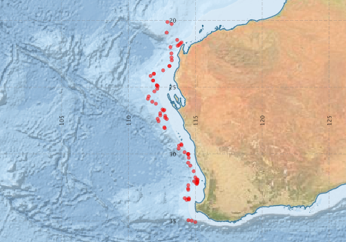
Voyage extents: 35° 04.9' S to 20° 07.8' S 111° 27.2' E to 115° 10.2' E
Marlin Metadata:-
Metadata from OBIS Australia datasets:- biological data is published via the OBIS-AU IPT server and delivered to one or more of OBIS, ALA and GBIF
Download from OBIS Australia IPT View at - Ocean Biodiversity Information System (OBIS) Atlas of Living Australia (ALA) GBIF
Download from OBIS Australia IPT View at - Ocean Biodiversity Information System (OBIS) Atlas of Living Australia (ALA) GBIF
Participants - on ship:-
| Name | Leg | Role | Organisation |
|---|---|---|---|
| Alan Williams | 1 2 | (Former) CSIRO Division of Fisheries/Fisheries Research - Hobart | |
| C Liron | 1 2 | (Former) CSIRO Division of Fisheries/Fisheries Research - Hobart | |
| C Stanley | 1 2 | (Former) CSIRO Division of Fisheries/Fisheries Research - Hobart | |
| Cathy Bulman | 1 2 | (Former) CSIRO Division of Fisheries/Fisheries Research - Hobart | |
| D Evans | 2 | (Former) CSIRO Division of Fisheries/Fisheries Research - Marmion | |
| G Johnson | 1 | (Former) CSIRO Division of Fisheries/Fisheries Research - Hobart | |
| J Paxton | 1 | Australian Museum | |
| M Gomon | 2 | Museum Victoria | |
| Matt Sherlock | 1 2 | (Former) CSIRO Division of Fisheries/Fisheries Research - Hobart | |
| P Jernakoff | 2 | (Former) CSIRO Division of Fisheries/Fisheries Research - Marmion | |
| Peter Last | 1 2 | (Former) CSIRO Division of Fisheries/Fisheries Research - Hobart | |
| Rudy Kloser | 1 2 | (Former) CSIRO Division of Fisheries/Fisheries Research - Hobart | |
| S Braine | 2 | (Former) CSIRO Division of Fisheries/Fisheries Research - Hobart | |
| S Rainer | 1 | (Former) CSIRO Division of Fisheries/Fisheries Research - Marmion | |
| Tony Koslow | 1 2 | Cruise Leader | (Former) CSIRO Division of Fisheries/Fisheries Research - Hobart |
| Victoria Wadley | 1 | (Former) CSIRO Division of Oceanography - Marmion |
This list includes those that may have only been on part of the voyage. See voyage reports on 'Reports and Maps' tab for details.
Marine National Facility Reports - plans, summaries and data processing
-
SS199101 Voyage Summary
- includes preliminary results, voyage narrative, types of data collected with C77/ROSCOP codes.
-
SS199101 Voyage Plan
- includes objectives, investigator details, proposed data collection, voyage track and equipment to be used.
-

Publications, reports and datasets from this voyage.
DwC Archive
- Australian National Fish Collection (ANFC) (Darwin Core Archive) External link to reference
- CSIRO, Cruise SS199101, Marine Biology Data, Western Australia, 1991
(Darwin Core Archive) External link to reference
Journal Article
- Evans, S.R., and J.F. Middleton, 1998: A Regional Model of Shelf Circulation near Bass Strait: A new upwelling mechanism. J. Phys. Oceanogr., 28, 1439-1457. 10.1175/1520-0485(1998)028%3C1439:ARMOSC%3E2.0.CO;2
- Moore, K. M., Alderslade, P. and Miller, K. J. (2017), A taxonomic revision of Antothela (Octocorallia: Scleraxonia: Antothelidae) and related genera, with the addition of new taxa, using morphological and molecular data. Zootaxa, 4304: pp. 001-212. 10.11646/zootaxa.4304.1.1
- Nakayama, Naohide,Prokofiev, Artem M.,Kawai, Toshio (2020) Coelorinchus posteromaculatus (Actinopterygii, Gadiformes, Macrouridae), a new species of grenadier from the eastern Indian Ocean. Ichthyological Research 67 pp465-472. 10.1007/s10228-020-00741-x
- Sazonov, Y. I. and Williams, A. (2001) A review of the Alepocephalid fishes (Argentiniformes, Alepocephalidae) from the continental slope of Australia: Part 1. Journal of Ichthyology 41 1-36
- Staples, David A. (2007), A new species of Colossendeis (Pycnogonida : Colossendeidae) together with records from Australian and New Zealand waters. Memoirs of Museum Victoria, 64: pp. 79-94. 10.24199/j.mmv.2007.64.8
- Williams, A., Koslow, J. A. and Last, P. R. (2001) Diversity, Density and Community Structure of the Demersal Fish Fauna of the Continental Slope Off Western Australia (20 to 35 Degrees S). Marine Ecology Progress Series 212 247-263 10.3354/meps212247
- Woods, Briannyn L.,Van de Putte, Anton P.,Hindell, Mark A.,Raymond, Ben,Saunders, Ryan A.,Walters, Andrea,Trebilco, Rowan (2023) Species distribution models describe spatial variability in mesopelagic fish abundance in the Southern Ocean. Frontiers in Marine Science 9 pp-. 10.3389/fmars.2022.981434
Search for publications, reports and datasets from this and other voyages
Data publishing
This is a list of online datasets hosted by CSIRO. Other processed datasets hosted by collaborating organisations may be found on the 'Metadata' or "Reports, Publications and Maps' tab.
Use the Get data link on the right to extract data using the NCMI Data Trawler.
| Data Stream | Data Summary | Get data | ||||||||||||
|---|---|---|---|---|---|---|---|---|---|---|---|---|---|---|
| Marine biodiversity observations and/or samples |
|
Get Data from Trawler |
||||||||||||
| Catch Details (deprecated - now bio) |
|
Get Data from Trawler |
Deployments by start time:- Click on column header to sort. Use link on 'Deployment' to see full details. Use the CSV button at the bottom to export data (tab delimited).
Search for deployments from this voyage and others
| Deployment | Operation | Station | Cast | Gear | Project | Start and end times | Start Location | End Location | Depth range | Max Depth | Description | |||
|---|---|---|---|---|---|---|---|---|---|---|---|---|---|---|
| Catch [details] | 2 | 70 | 1991-01-23 06:05 | 1991-01-23 06:35 | -20.2750 | 113.2250 | -20.2967 | 113.2050 | 913 to 914 | 914 | Area WA_Slope | |||
| Catch [details] | 3 | 70 | 1991-01-23 10:25 | 1991-01-23 10:55 | -20.1300 | 112.9183 | 868 to 854 | 868 | Area WA_Slope | |||||
| Catch [details] | 4 | 70 | 1991-01-23 20:10 | 1991-01-23 21:00 | -20.9233 | 112.8583 | -20.8867 | 112.8717 | 1139 to 1128 | 1139 | Area WA_Slope | |||
| Catch [details] | 11 | 70 | 1991-01-24 00:15 | 1991-01-24 00:45 | -21.9017 | 113.6783 | -21.8583 | 113.6950 | 1158 to 1100 | 1158 | Area WA_Slope | |||
| Catch [details] | 5 | 70 | 1991-01-24 05:30 | 1991-01-24 06:05 | -21.4700 | 113.6433 | -21.4817 | 113.6700 | 1022 to 1023 | 1023 | Area WA_Slope | |||
| Catch [details] | 7 | 70 | 1991-01-24 11:00 | 1991-01-24 11:30 | -21.6550 | 113.9700 | -21.6317 | 113.9883 | 209 to 215 | 215 | Area WA_Slope | |||
| Catch [details] | 8 | 70 | 1991-01-24 14:36 | 1991-01-24 14:52 | -21.7450 | 113.8717 | -21.7417 | 113.8750 | 320 to 290 | 320 | Area WA_Slope | |||
| Catch [details] | 10 | 70 | 1991-01-24 20:15 | 1991-01-24 21:00 | -21.8433 | 113.7783 | -21.8183 | 113.7933 | 685 to 650 | 685 | Area WA_Slope | |||
| Catch [details] | 12 | 70 | 1991-01-25 07:40 | 1991-01-25 08:10 | -22.0083 | 113.1400 | -21.9783 | 113.1450 | 1460 to 1700 | 1700 | Area WA_Slope | |||
| Catch [details] | 13 | 70 | 1991-01-25 13:55 | 1991-01-25 14:40 | -22.4767 | 113.2067 | -22.4367 | 113.2050 | 1258 to 1305 | 1305 | Area WA_Slope | |||
| Catch [details] | 14 | 70 | 1991-01-25 19:38 | 1991-01-25 20:10 | -22.7900 | 113.2200 | -22.7633 | 113.2267 | 880 to 910 | 910 | Area WA_Slope | |||
| Catch [details] | 15 | 70 | 1991-01-26 01:10 | 1991-01-26 01:40 | -22.9983 | 113.2383 | -22.9600 | 113.2400 | 482 to 544 | 544 | Area WA_Slope | |||
| Catch [details] | 16 | 70 | 1991-01-26 06:30 | 1991-01-26 07:00 | -23.4233 | 113.0650 | -23.3950 | 113.0917 | 297 to 311 | 311 | Area WA_Slope | |||
| Catch [details] | 17 | 70 | 1991-01-26 08:25 | 1991-01-26 09:00 | -23.4233 | 113.0650 | -23.3933 | 113.0850 | 300 to 302 | 302 | Area WA_Slope | |||
| Catch [details] | 19 | 70 | 1991-01-26 20:10 | 1991-01-26 20:40 | -23.7433 | 112.5917 | -23.7150 | 112.5983 | 612 to 620 | 620 | Area WA_Slope | |||
| Catch [details] | 21 | 70 | 1991-01-27 05:50 | 1991-01-27 06:30 | -24.0067 | 111.9017 | -23.9783 | 111.9067 | 1060 to 1064 | 1064 | Area WA_Slope | |||
| Catch [details] | 22 | 70 | 1991-01-27 08:55 | 1991-01-27 09:25 | -23.9917 | 111.9017 | -23.9600 | 111.9050 | 1061 to 1071 | 1071 | Area WA_Slope | |||
| Catch [details] | 23 | 70 | 1991-01-27 15:00 | 1991-01-27 15:45 | -24.1600 | 111.6583 | -24.1250 | 111.6567 | 1293 to 1320 | 1320 | Area WA_Slope | |||
| Catch [details] | 24 | 70 | 1991-01-28 00:50 | 1991-01-28 01:30 | -24.5033 | 111.8483 | -24.4683 | 111.8567 | 892 to 905 | 905 | Area WA_Slope | |||
| Catch [details] | 25 | 70 | 1991-01-28 02:45 | 1991-01-28 03:30 | -24.5100 | 111.8400 | -24.5367 | 111.8083 | 895 to 901 | 901 | Area WA_Slope | |||
| Catch [details] | 26 | 70 | 1991-01-28 08:40 | 1991-01-28 09:05 | -24.8550 | 112.1183 | -24.8317 | 112.1183 | 467 to 478 | 478 | Area WA_Slope | |||
| Catch [details] | 27 | 70 | 1991-01-28 12:05 | 1991-01-28 12:35 | -24.8817 | 112.1300 | -24.8600 | 112.1150 | 444 to 468 | 468 | Area WA_Slope | |||
| Catch [details] | 28 | 70 | 1991-01-28 14:33 | 1991-01-28 15:25 | -24.9283 | 112.1900 | -24.8900 | 112.1867 | 318 to 344 | 344 | Area WA_Slope | |||
| Catch [details] | 30 | 70 | 1991-01-28 21:00 | 1991-01-28 21:35 | -25.1250 | 112.1550 | -25.1500 | 112.1583 | 312 to 312 | 312 | Area WA_Slope | |||
| Catch [details] | 31 | 70 | 1991-01-29 01:40 | 1991-01-29 02:15 | -25.3183 | 111.9417 | -25.2867 | 111.9383 | 612 to 610 | 612 | Area WA_Slope | |||
| Catch [details] | 32 | 70 | 1991-01-29 07:10 | 1991-01-29 07:40 | -25.6867 | 111.5150 | -25.7067 | 111.5050 | 1115 to 1125 | 1125 | Area WA_Slope | |||
| Catch [details] | 33 | 70 | 1991-01-29 12:25 | 1991-01-29 13:00 | -25.8683 | 111.4533 | -25.8250 | 111.4417 | 1254 to 1277 | 1277 | Area WA_Slope | |||
| Catch [details] | 35 | 70 | 1991-01-30 00:20 | 1991-01-30 00:45 | -26.0883 | 111.7783 | -26.0733 | 111.7850 | 882 to 874 | 882 | Area WA_Slope | |||
| Catch [details] | 36 | 70 | 1991-01-30 04:35 | 1991-01-30 05:10 | -26.2417 | 112.0533 | -26.2133 | 112.0400 | 690 to 691 | 691 | Area WA_Slope | |||
| Catch [details] | 38 | 70 | 1991-01-30 16:30 | 1991-01-30 17:10 | -26.6733 | 112.5450 | -26.7150 | 112.5583 | 478 to 456 | 478 | Area WA_Slope | |||
| Catch [details] | 39 | 70 | 1991-01-30 19:10 | 1991-01-30 19:40 | -26.7100 | 112.6850 | -26.6800 | 112.6750 | 200 to 194 | 200 | Area WA_Slope | |||
| Catch [details] | 41 | 70 | 1991-01-31 03:12 | 1991-01-31 03:55 | -26.7500 | 112.6100 | -26.7883 | 112.5983 | 346 to 367 | 367 | Area WA_Slope | |||
| Catch [details] | 42 | 70 | 1991-01-31 06:28 | 1991-01-31 06:58 | -26.9500 | 112.3717 | -26.9700 | 112.3567 | 666 to 688 | 688 | Area WA_Slope | |||
| Catch [details] | 43 | 70 | 1991-01-31 10:05 | 1991-01-31 10:35 | -27.1133 | 112.3817 | -27.0833 | 112.3717 | 714 to 713 | 714 | Area WA_Slope | |||
| Catch [details] | 44 | 70 | 1991-01-31 15:00 | 1991-01-31 15:30 | -27.3683 | 112.1800 | -27.3433 | 112.1733 | 1009 to 996 | 1009 | Area WA_Slope | |||
| Catch [details] | 47 | 70 | 1991-02-01 00:15 | 1991-02-01 00:40 | -27.5467 | 112.2533 | -27.5567 | 112.2667 | 1104 to 1110 | 1110 | Area WA_Slope | |||
| Catch [details] | 48 | 70 | 1991-02-01 09:50 | 1991-02-01 10:20 | -28.0000 | 112.6833 | -27.9667 | 112.7017 | 945 to 946 | 946 | Area WA_Slope | |||
| Catch [details] | 49 | 70 | 1991-02-01 12:35 | 1991-02-01 13:15 | -28.0683 | 112.7100 | -28.0100 | 112.6983 | 854 to 853 | 854 | Area WA_Slope | |||
| Catch [details] | 51 | 70 | 1991-02-02 16:10 | 1991-02-02 16:40 | -27.2867 | 112.7533 | -27.2633 | 112.7417 | 510 to 520 | 520 | Area WA_Slope | |||
| Catch [details] | 52 | 70 | 1991-02-02 19:30 | 1991-02-02 20:15 | -27.1467 | 112.7467 | -27.1067 | 112.7350 | 438 to 370 | 438 | Area WA_Slope | |||
| Catch [details] | 54 | 70 | 1991-02-03 06:15 | 1991-02-03 06:50 | -27.3833 | 112.8650 | -27.3467 | 112.8633 | 306 to 279 | 306 | Area WA_Slope | |||
| Catch [details] | 56 | 70 | 1991-02-06 09:55 | 1991-02-06 10:30 | -29.2633 | 113.9467 | 0.0000 | 0.0000 | 320 to 325 | 325 | Area WA_Slope | |||
| Catch [details] | 57 | 70 | 1991-02-06 14:00 | 1991-02-06 14:45 | -29.3417 | 113.9717 | -29.3100 | 113.9467 | 490 to 505 | 505 | Area WA_Slope | |||
| Catch [details] | 58 | 70 | 1991-02-06 18:40 | 1991-02-06 19:10 | -29.3633 | 113.7767 | -29.3400 | 113.7650 | 942 to 970 | 970 | Area WA_Slope | |||
| Catch [details] | 61 | 70 | 1991-02-07 15:35 | 1991-02-07 16:05 | -29.5900 | 113.7483 | -29.5667 | 113.7450 | 1132 to 1136 | 1136 | Area WA_Slope | |||
| Catch [details] | 62 | 70 | 1991-02-07 22:30 | 1991-02-07 23:00 | -29.8650 | 114.1933 | -29.8383 | 114.1817 | 770 to 760 | 770 | Area WA_Slope | |||
| Catch [details] | 63 | 70 | 1991-02-08 09:40 | 1991-02-08 10:10 | -30.0200 | 114.4867 | -29.9950 | 114.4733 | 255 to 265 | 265 | Area WA_Slope | |||
| Catch [details] | 64 | 70 | 1991-02-08 11:35 | 1991-02-08 12:10 | -30.0017 | 114.4633 | -29.9683 | 114.4517 | 380 to 380 | 380 | Area WA_Slope | |||
| Catch [details] | 65 | 70 | 1991-02-08 14:30 | 1991-02-08 15:00 | -30.0000 | 114.4517 | -29.9767 | 114.4417 | 480 to 490 | 490 | Area WA_Slope | |||
| Catch [details] | 66 | 70 | 1991-02-08 21:45 | 1991-02-08 22:15 | -30.2783 | 114.5033 | -30.2533 | 114.4950 | 684 to 684 | 684 | Area WA_Slope | |||
| Catch [details] | 67 | 70 | 1991-02-09 07:10 | 1991-02-09 07:35 | -30.6517 | 114.4617 | -30.6500 | 114.4600 | 1058 to 1080 | 1080 | Area WA_Slope | |||
| Catch [details] | 68 | 70 | 1991-02-09 13:36 | 1991-02-09 14:07 | -30.8650 | 114.6217 | -30.8417 | 114.6150 | 893 to 887 | 893 | Area WA_Slope | |||
| Catch [details] | 70 | 70 | 1991-02-09 22:40 | 1991-02-09 23:20 | -31.2833 | 114.8767 | -31.2483 | 114.8717 | 475 to 512 | 512 | Area WA_Slope | |||
| Catch [details] | 71 | 70 | 1991-02-10 08:23 | 1991-02-10 08:55 | -31.7450 | 114.9950 | -31.7167 | 114.9783 | 390 to 485 | 485 | Area WA_Slope | |||
| Catch [details] | 72 | 70 | 1991-02-10 12:40 | 1991-02-10 13:10 | -32.0383 | 114.9083 | -32.0133 | 114.9167 | 670 to 640 | 670 | Area WA_Slope | |||
| Catch [details] | 73 | 70 | 1991-02-10 19:43 | 1991-02-10 20:26 | -31.8867 | 115.0950 | -31.9017 | 115.0767 | 411 to 550 | 550 | Area WA_Slope | |||
| Catch [details] | 74 | 70 | 1991-02-11 09:15 | 1991-02-11 10:15 | -31.9200 | 115.1700 | -31.9567 | 115.1417 | 320 to 850 | 850 | Area WA_Slope | |||
| Catch [details] | 75 | 70 | 1991-02-11 17:00 | 1991-02-11 17:35 | -32.1633 | 115.0467 | -32.1317 | 115.0633 | 484 to 470 | 484 | Area WA_Slope | |||
| Catch [details] | 76 | 70 | 1991-02-12 07:15 | 1991-02-12 07:50 | -32.1317 | 115.1117 | -32.1017 | 115.1350 | 308 to 295 | 308 | Area WA_Slope | |||
| Catch [details] | 77 | 70 | 1991-02-12 09:55 | 1991-02-12 10:20 | -32.0817 | 115.1567 | -32.0567 | 115.1700 | 270 to 285 | 285 | Area WA_Slope | |||
| Catch [details] | 78 | 70 | 1991-02-12 13:10 | 1991-02-12 13:40 | -32.0383 | 115.1483 | -32.0100 | 115.1617 | 510 to 510 | 510 | Area WA_Slope | |||
| Catch [details] | 80 | 70 | 1991-02-13 09:30 | 1991-02-13 10:10 | -32.2400 | 115.1067 | -32.2067 | 115.0917 | 286 to 287 | 287 | Area WA_Slope | |||
| Catch [details] | 81 | 70 | 1991-02-13 12:30 | 1991-02-13 13:08 | -32.1700 | 115.1367 | -32.1400 | 115.1500 | 225 to 230 | 230 | Area WA_Slope | |||
| Catch [details] | 82 | 70 | 1991-02-13 19:35 | 1991-02-13 20:05 | -32.3300 | 114.4767 | -32.3050 | 114.4833 | 1280 to 1310 | 1310 | Area WA_Slope | |||
| Catch [details] | 83 | 70 | 1991-02-14 07:35 | 1991-02-14 08:05 | -32.5767 | 114.4533 | -32.5500 | 114.4300 | 1030 to 1140 | 1140 | Area WA_Slope | |||
| Catch [details] | 84 | 70 | 1991-02-14 11:48 | 1991-02-14 12:30 | -32.6733 | 114.4700 | -32.6467 | 114.4400 | 880 to 960 | 960 | Area WA_Slope | |||
| Catch [details] | 85 | 70 | 1991-02-14 22:45 | 1991-02-14 23:20 | -33.2983 | 114.2100 | -33.2633 | 114.1850 | 982 to 982 | 982 | Area WA_Slope | |||
| Catch [details] | 87 | 70 | 1991-02-15 23:00 | 1991-02-15 23:25 | -33.2983 | 114.5133 | -33.3183 | 114.5100 | 468 to 430 | 468 | Area WA_Slope | |||
| Catch [details] | 88 | 70 | 1991-02-16 08:20 | 1991-02-16 09:50 | -33.4017 | 114.5233 | -33.3750 | 114.5300 | 203 to 204 | 204 | Area WA_Slope | |||
| Catch [details] | 89 | 70 | 1991-02-16 10:55 | 1991-02-16 11:25 | -33.3817 | 114.4933 | -33.3567 | 114.5100 | 399 to 350 | 399 | Area WA_Slope | |||
| Catch [details] | 90 | 70 | 1991-02-16 13:55 | 1991-02-16 14:25 | -33.4250 | 114.3500 | -33.4100 | 114.3750 | 817 to 780 | 817 | Area WA_Slope | |||
| Catch [details] | 94 | 70 | 1991-02-18 10:50 | 1991-02-18 11:20 | -34.9483 | 114.4883 | -34.9550 | 114.4833 | 900 to 958 | 958 | Area WA_Slope | |||
| Catch [details] | 95 | 70 | 1991-02-18 16:15 | 1991-02-18 16:40 | -34.9867 | 114.7267 | -35.0033 | 114.7150 | 738 to 750 | 750 | Area WA_Slope | |||
| Catch [details] | 96 | 70 | 1991-02-18 21:40 | 1991-02-18 22:05 | -35.0817 | 114.9950 | -35.0983 | 114.9733 | 870 to 920 | 920 | Area WA_Slope | |||