Survey details and related metadata, reports, events and data.
SS 03/90 (alternative identifier: SS199003)
Period: 1990-11-19 00:00 to 1990-12-17 00:00 UTC
Duration: 28.00 days
Region: Gulf of Carpentaria, W Torres Strait
Ship: Southern Surveyor [details]
Description: Southern Surveyor cruise SS 03/90 was undertaken to carry out the first fisheries survey, and benthic sampling in the Gulf of Carpentaria, the south eastern Arafura Sea and western Torres Strait Protection Zone. The primary aim of the cruise was to determine the commercial fin fish recources and the distribution of the demersal fish fauna in relation to: the distribution of the benthos, sediments and depth in these areas. Secondary aim was to determine which species of fish feed on penaeid prawns in selected prawn-trawl areas of the GOC; to describe the bycatch and determine the fate of bycatch of commercial fish trawls and differences in the fish communities of areas of high and low prawn trawl effort.
Leader: I. Poiner & S. Blaber (CSIRO)
Project: The fish resources of tropical north-eastern Australian waters (FIRDC project no. 88/77) 1989-1992 [details]
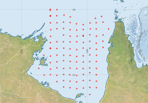
Voyage extents: 17° 00.0' S to 8° 00.0' S 135° 00.0' E to 144° 00.0' E
Marlin Metadata:-
Metadata from OBIS Australia datasets:- biological data is published via the OBIS-AU IPT server and delivered to one or more of OBIS, ALA and GBIF
Download from OBIS Australia IPT View at - Ocean Biodiversity Information System (OBIS) Atlas of Living Australia (ALA) GBIF
Download from OBIS Australia IPT View at - Ocean Biodiversity Information System (OBIS) Atlas of Living Australia (ALA) GBIF
Download from OBIS Australia IPT View at - Ocean Biodiversity Information System (OBIS) Atlas of Living Australia (ALA) GBIF
Participants:- no records
Marine National Facility Reports - plans, summaries and data processing
-
SS199003 Voyage Plan
- includes objectives, investigator details, proposed data collection, voyage track and equipment to be used.
-
SS199003 Voyage Report
- includes preliminary results, voyage narrative, types of data collected with C77/ROSCOP codes.
-

Publications, reports and datasets from this voyage.
DwC Archive
- Australian National Fish Collection (ANFC) (Darwin Core Archive) External link to reference
- Distribution of seabirds at sea in the Gulf of Carpentaria, Australia (1990-1991) (Darwin Core Archive) External link to reference
- North Marine Region demersal fish and invertebrate collection records (DEW collation), Australia (1980 - 1997) (Darwin Core Archive) External link to reference
Journal Article
- Dunning, M,McKinnon, S,Lu, CC,Yeatman, J,Cameron, D (1994) Demersal cephalopods of the Gulf of Carpentaria, Australia. Marine and Freshwater Research 45 pp351-. 10.1071/MF9940351
- Martin, TJ,Brewer, DT,Blaber, SJM (1995) Factors affecting distribution and abundance of small demersal fishes in the Gulf of Carpentaria, Australia. Marine and Freshwater Research 46 pp909-. 10.1071/MF9950909
- Staunton-Smith, J.,Blaber, S. J. M.,Greenwood, J. G. (1999) Interspecific differences in the distribution of adult and juvenile ponyfish (Leiognathidae) in the Gulf of Carpentaria, Australia. Marine and Freshwater Research 50 pp643-. 10.1071/MF99007
Search for publications, reports and datasets from this and other voyages
Data publishing
This is a list of online datasets hosted by CSIRO. Other processed datasets hosted by collaborating organisations may be found on the 'Metadata' or "Reports, Publications and Maps' tab.
Use the Get data link on the right to extract data using the NCMI Data Trawler.
| Data Stream | Data Summary | Get data | ||||||||||||
|---|---|---|---|---|---|---|---|---|---|---|---|---|---|---|
| Marine biodiversity observations and/or samples |
|
Get Data from Trawler |
Deployments by start time:- Click on column header to sort. Use link on 'Deployment' to see full details. Use the CSV button at the bottom to export data (tab delimited).
Search for deployments from this voyage and others
| Deployment | Operation | Station | Cast | Gear | Project | Start and end times | Start Location | End Location | Depth range | Max Depth | Description | |||
|---|---|---|---|---|---|---|---|---|---|---|---|---|---|---|
| Sediment Sampling [details] | 100GB100 | 543 | -12.9793 | 137.6905 | ||||||||||
| Sediment Sampling [details] | 101GB101 | 543 | -12.4618 | 137.6925 | ||||||||||
| Sediment Sampling [details] | 102GB102 | 543 | -11.9839 | 139.6965 | ||||||||||
| Sediment Sampling [details] | 103GB103 | 543 | -11.4649 | 137.6957 | ||||||||||
| Sediment Sampling [details] | 104GB104 | 543 | -11.0069 | 137.7003 | ||||||||||
| Sediment Sampling [details] | 105GB105 | 543 | -10.4684 | 137.6808 | ||||||||||
| Sediment Sampling [details] | 106GB106 | 543 | -10.0044 | 137.7005 | ||||||||||
| Sediment Sampling [details] | 107GB107 | 543 | -9.9832 | 137.1952 | ||||||||||
| Sediment Sampling [details] | 108GB108 | 543 | -10.4668 | 137.2007 | ||||||||||
| Sediment Sampling [details] | 10GB010 | 543 | -13.5617 | 137.2067 | ||||||||||
| Sediment Sampling [details] | 11GB011 | 543 | -14.0573 | 137.1873 | ||||||||||
| Sediment Sampling [details] | 12GB012 | 543 | -14.5562 | 137.2118 | ||||||||||
| Sediment Sampling [details] | 14GB014 | 543 | -14.4967 | 136.3167 | ||||||||||
| Sediment Sampling [details] | 15GB015 | 543 | -15.0121 | 136.7285 | ||||||||||
| Sediment Sampling [details] | 16GB016 | 543 | -14.9835 | 137.1963 | ||||||||||
| Sediment Sampling [details] | 17GB017 | 543 | -15.9283 | 138.2092 | ||||||||||
| Sediment Sampling [details] | 18GB018 | 543 | -15.4397 | 138.2023 | ||||||||||
| Sediment Sampling [details] | 19GB019 | 543 | -14.9668 | 138.2078 | ||||||||||
| Sediment Sampling [details] | 1GB001 | 543 | -10.0533 | 137.1867 | ||||||||||
| Sediment Sampling [details] | 20GB020 | 543 | -14.5102 | 138.2050 | ||||||||||
| Sediment Sampling [details] | 21GB021 | 543 | -13.9104 | 138.2007 | ||||||||||
| Sediment Sampling [details] | 22GB022 | 543 | -13.4954 | 138.2122 | ||||||||||
| Sediment Sampling [details] | 23GB023 | 543 | -12.9540 | 138.2105 | ||||||||||
| Sediment Sampling [details] | 24GB024 | 543 | -12.4654 | 138.1893 | ||||||||||
| Sediment Sampling [details] | 25GB025 | 543 | -11.9484 | 138.1958 | ||||||||||
| Sediment Sampling [details] | 26GB026 | 543 | -11.4409 | 138.2035 | ||||||||||
| Sediment Sampling [details] | 27GB027 | 543 | -10.9588 | 138.1935 | ||||||||||
| Sediment Sampling [details] | 28GB028 | 543 | -10.4237 | 138.2402 | ||||||||||
| Sediment Sampling [details] | 29GB029 | 543 | -11.0861 | 139.1850 | ||||||||||
| Sediment Sampling [details] | 2GB002 | 543 | -10.5020 | 137.2005 | ||||||||||
| Sediment Sampling [details] | 30GB030 | 543 | -11.5704 | 139.1975 | ||||||||||
| Sediment Sampling [details] | 31GB031 | 543 | -12.0338 | 139.2343 | ||||||||||
| Sediment Sampling [details] | 32GB032 | 543 | -12.4663 | 139.2000 | ||||||||||
| Sediment Sampling [details] | 33GB033 | 543 | -13.0646 | 139.2082 | ||||||||||
| Sediment Sampling [details] | 34GB034 | 543 | -13.5852 | 139.1955 | ||||||||||
| Sediment Sampling [details] | 35GB035 | 543 | -13.9990 | 139.1927 | ||||||||||
| Sediment Sampling [details] | 36GB036 | 543 | -14.5097 | 139.2015 | ||||||||||
| Sediment Sampling [details] | 37GB037 | 543 | -15.0487 | 139.2040 | ||||||||||
| Sediment Sampling [details] | 38GB038 | 543 | -15.5398 | 139.1948 | ||||||||||
| Sediment Sampling [details] | 39GB039 | 543 | -16.0483 | 139.2093 | ||||||||||
| Sediment Sampling [details] | 3GB003 | 543 | -11.0117 | 137.1967 | ||||||||||
| Sediment Sampling [details] | 40GB040 | 543 | -16.4987 | 140.1972 | ||||||||||
| Sediment Sampling [details] | 41GB041 | 543 | -15.9556 | 140.2052 | ||||||||||
| Sediment Sampling [details] | 42GB042 | 543 | -15.4214 | 140.1990 | ||||||||||
| Sediment Sampling [details] | 43GB043 | 543 | -14.8341 | 140.1983 | ||||||||||
| Sediment Sampling [details] | 44GB044 | 543 | -14.4663 | 140.1920 | ||||||||||
| Sediment Sampling [details] | 45GB045 | 543 | -13.9788 | 140.1898 | ||||||||||
| Sediment Sampling [details] | 46GB046 | 543 | -13.4670 | 140.1990 | ||||||||||
| Sediment Sampling [details] | 47GB047 | 543 | -12.9616 | 140.2133 | ||||||||||
| Sediment Sampling [details] | 48GB048 | 543 | -12.4339 | 140.1960 | ||||||||||
| Sediment Sampling [details] | 49GB049 | 543 | -11.9290 | 140.2025 | ||||||||||
| Sediment Sampling [details] | 4GB004 | 543 | -11.5450 | 137.2300 | ||||||||||
| Sediment Sampling [details] | 50GB050 | 543 | -11.4751 | 140.2393 | ||||||||||
| Sediment Sampling [details] | 51GB051 | 543 | -12.0280 | 140.7077 | ||||||||||
| Sediment Sampling [details] | 52GB052 | 543 | -12.4220 | 141.1927 | ||||||||||
| Sediment Sampling [details] | 53GB053 | 543 | -11.9406 | 141.2137 | ||||||||||
| Sediment Sampling [details] | 54GB054 | 543 | -11.4849 | 141.6233 | ||||||||||
| Sediment Sampling [details] | 56GB056 | 543 | -10.9617 | 141.2020 | ||||||||||
| Sediment Sampling [details] | 57GB057 | 543 | -10.5243 | 141.1027 | ||||||||||
| Sediment Sampling [details] | 58GB058 | 543 | -10.6633 | 140.6233 | ||||||||||
| Sediment Sampling [details] | 59GB059 | 543 | -11.0237 | 140.2185 | ||||||||||
| Sediment Sampling [details] | 5GB005 | 543 | -12.0490 | 137.2078 | ||||||||||
| Sediment Sampling [details] | 60GB060 | 543 | -11.0039 | 140.6867 | ||||||||||
| Sediment Sampling [details] | 61GB061 | 543 | -11.4820 | 140.6917 | ||||||||||
| Sediment Sampling [details] | 62GB062 | 543 | -12.5722 | 140.6952 | ||||||||||
| Sediment Sampling [details] | 63GB063 | 543 | -13.0434 | 140.6988 | ||||||||||
| Sediment Sampling [details] | 64GB064 | 543 | -12.8938 | 141.2125 | ||||||||||
| Sediment Sampling [details] | 65GB065 | 543 | -13.4997 | 140.7073 | ||||||||||
| Sediment Sampling [details] | 66GB066 | 543 | -13.9700 | 140.6995 | ||||||||||
| Sediment Sampling [details] | 67GB067 | 543 | -14.5094 | 140.7035 | ||||||||||
| Sediment Sampling [details] | 69GB069 | 543 | -14.9844 | 140.7003 | ||||||||||
| Sediment Sampling [details] | 6GB006 | 543 | -12.5233 | 137.2000 | ||||||||||
| Sediment Sampling [details] | 70GB070 | 543 | -15.4815 | 140.7013 | ||||||||||
| Sediment Sampling [details] | 71GB071 | 543 | -15.9725 | 140.7015 | ||||||||||
| Sediment Sampling [details] | 72GB072 | 543 | -16.0057 | 139.7128 | ||||||||||
| Sediment Sampling [details] | 73GB073 | 543 | -15.4313 | 139.6985 | ||||||||||
| Sediment Sampling [details] | 74GB074 | 543 | -14.9651 | 139.7053 | ||||||||||
| Sediment Sampling [details] | 75GB075 | 543 | -14.5110 | 139.6955 | ||||||||||
| Sediment Sampling [details] | 76GB076 | 543 | -14.0157 | 139.7005 | ||||||||||
| Sediment Sampling [details] | 77GB077 | 543 | -13.5383 | 139.6975 | ||||||||||
| Sediment Sampling [details] | 78GB078 | 543 | -12.9452 | 139.6965 | ||||||||||
| Sediment Sampling [details] | 79GB079 | 543 | -12.5131 | 139.7077 | ||||||||||
| Sediment Sampling [details] | 7GB007 | 543 | -12.9783 | 137.1967 | ||||||||||
| Sediment Sampling [details] | 80GB080 | 543 | -12.0266 | 139.6970 | ||||||||||
| Sediment Sampling [details] | 81GB081 | 543 | -11.5295 | 139.6940 | ||||||||||
| Sediment Sampling [details] | 82GB082 | 543 | -11.1506 | 139.6970 | ||||||||||
| Sediment Sampling [details] | 83GB083 | 543 | -10.5624 | 138.7160 | ||||||||||
| Sediment Sampling [details] | 84GB084 | 543 | -10.9899 | 138.7023 | ||||||||||
| Sediment Sampling [details] | 85GB085 | 543 | -11.5373 | 138.6985 | ||||||||||
| Sediment Sampling [details] | 86GB086 | 543 | -12.0366 | 138.7047 | ||||||||||
| Sediment Sampling [details] | 87GB087 | 543 | -12.4755 | 138.7000 | ||||||||||
| Sediment Sampling [details] | 88GB088 | 543 | -13.0101 | 138.6980 | ||||||||||
| Sediment Sampling [details] | 89GB089 | 543 | -13.5039 | 138.7005 | ||||||||||
| Sediment Sampling [details] | 8GB008 | 543 | -12.9550 | 137.1967 | ||||||||||
| Sediment Sampling [details] | 90GB090 | 543 | -13.9652 | 138.7058 | ||||||||||
| Sediment Sampling [details] | 91GB091 | 543 | -14.4750 | 138.6997 | ||||||||||
| Sediment Sampling [details] | 92GB092 | 543 | -14.9879 | 138.6785 | ||||||||||
| Sediment Sampling [details] | 93GB093 | 543 | -15.4816 | 138.6942 | ||||||||||
| Sediment Sampling [details] | 94GB094 | 543 | -15.9800 | 138.6947 | ||||||||||
| Sediment Sampling [details] | 95GB095 | 543 | -15.5137 | 137.6988 | ||||||||||
| Sediment Sampling [details] | 96GB096 | 543 | -15.0232 | 137.6920 | ||||||||||
| Sediment Sampling [details] | 97GB097 | 543 | -14.4641 | 137.6917 | ||||||||||
| Sediment Sampling [details] | 98GB098 | 543 | -13.9993 | 137.7015 | ||||||||||
| Sediment Sampling [details] | 99GB099 | 543 | -13.4847 | 137.6985 | ||||||||||
| Sediment Sampling [details] | 9GB009 | 543 | -13.4950 | 136.7000 | ||||||||||