Survey details and related metadata, reports, events and data.
SP 03/80 (alternative identifier: SP198003)
Period: 1980-02-05 00:00 to 1980-02-12 00:00 Local
Duration: 7.00 days
From: Port Kembla To: Sydney
Region: NSW coast/Tasman Sea
Ship: Sprightly [details]
Description: East Australian Current/eddy studies, including underway physical and nutrient data, plus Nansen casts, midwater trawls, and squid fishing across the eddy. (NB voyage SP 03/80 and voyage SP 04/80 appear to be alternative numbers for the same voyage)
Leader: F.B. Griffiths (CSIRO)
Project: East Australian Current and eddy studies ("Courageous", "Sprightly"), 1978-1984 [details]
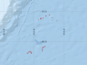
Voyage extents: 36° 24.0' S to 35° 09.0' S 151° 55.0' E to 152° 46.0' E
Marlin Metadata:-
Metadata from OBIS Australia datasets:- biological data is published via the OBIS-AU IPT server and delivered to one or more of OBIS, ALA and GBIF
Download from OBIS Australia IPT View at - Ocean Biodiversity Information System (OBIS) Atlas of Living Australia (ALA) GBIF
Participants:- no records
Marine National Facility Reports - plans, summaries and data processing
- View the Survey Summary report - includes preliminary results, voyage narrative, types of data collected with C77/ROSCOP codes.
- View Survey map
Search for publications, reports and datasets from this and other voyages
Data publishing
This is a list of online datasets hosted by CSIRO. Other processed datasets hosted by collaborating organisations may be found on the 'Metadata' or "Reports, Publications and Maps' tab.
Use the Get data link on the right to extract data using the NCMI Data Trawler.
| Data Stream | Data Summary | Get data | ||||||||||
|---|---|---|---|---|---|---|---|---|---|---|---|---|
| Marine biodiversity observations and/or samples |
|
Get Data from Trawler |
||||||||||
| Catch Details (deprecated - now bio) |
|
Get Data from Trawler |
||||||||||
| Hydrology |
|
Get Data from Trawler |
Deployments by start time:- Click on column header to sort. Use link on 'Deployment' to see full details. Use the CSV button at the bottom to export data (tab delimited).
Search for deployments from this voyage and others
| Deployment | Operation | Station | Cast | Gear | Project | Start and end times | Start Location | End Location | Depth range | Max Depth | Description | |||
|---|---|---|---|---|---|---|---|---|---|---|---|---|---|---|
| Hydrology Cast [details] | 1 | 12 | 1980-02-05 00:00 | 1980-02-05 00:00 | -36.2000 | 152.3000 | 789 | |||||||
| Catch [details] | 1 | Rectangular Midwater Trawl 8 | 12 | 1980-02-06 20:10 | 1980-02-06 21:50 | -36.1667 | 152.3667 | -36.1833 | 152.3500 | 58 | Trawling | |||
| Catch [details] | 2 | Rectangular Midwater Trawl 8 | 12 | 1980-02-06 22:45 | 1980-02-07 00:25 | -36.1833 | 152.3333 | -36.2000 | 152.3167 | 92 | Trawling | |||
| Catch [details] | 6 | Rectangular Midwater Trawl 8 | 12 | 1980-02-07 21:10 | 1980-02-07 22:50 | -35.2000 | 152.6000 | -35.1500 | 152.5500 | 41 | Trawling | |||
| Hydrology Cast [details] | 1 | 12 | 1980-02-08 00:00 | 1980-02-08 00:00 | -35.3000 | 152.7667 | 791 | |||||||
| Hydrology Cast [details] | 1 | 12 | 1980-02-08 00:00 | 1980-02-08 00:00 | -35.1500 | 152.4000 | 747 | |||||||
| Catch [details] | 3 | Rectangular Midwater Trawl 8 | 12 | 1980-02-08 00:55 | 1980-02-08 02:35 | -36.2167 | 152.3000 | -36.2333 | 152.2833 | 98 | Trawling | |||
| Catch [details] | 4 | Rectangular Midwater Trawl 8 | 12 | 1980-02-08 02:55 | 1980-02-08 04:35 | -36.2667 | 152.2833 | -36.2833 | 152.2833 | 65 | Trawling | |||
| Catch [details] | 5 | Rectangular Midwater Trawl 8 | 12 | 1980-02-08 05:00 | 1980-02-08 06:40 | -36.3167 | 152.2833 | -36.3333 | 152.2833 | 51 | Trawling | |||
| Catch [details] | 7 | Rectangular Midwater Trawl 8 | 12 | 1980-02-08 23:15 | 1980-02-09 00:55 | -35.1167 | 152.5167 | -35.0833 | 152.4833 | 120 | Trawling | |||
| Catch [details] | 8 | Rectangular Midwater Trawl 8 | 12 | 1980-02-09 18:30 | 1980-02-09 20:10 | -36.3833 | 151.9167 | -36.3667 | 151.9000 | 505 | Trawling | |||
| Catch [details] | 9 | Rectangular Midwater Trawl 8 | 12 | 1980-02-09 20:10 | 1980-02-09 21:50 | -36.3500 | 151.9000 | 235 | Trawling | |||||
| Catch [details] | 10 | Rectangular Midwater Trawl 8 | 12 | 1980-02-09 21:57 | 1980-02-09 23:37 | -36.3333 | 151.8667 | -36.3500 | 151.8333 | 290 | Trawling | |||
| Catch [details] | 11 | Rectangular Midwater Trawl 8 | 12 | 1980-02-09 23:35 | 1980-02-10 01:15 | -36.3500 | 151.8333 | -36.3667 | 151.8000 | 82 | Trawling | |||
| Hydrology Cast [details] | 1 | 12 | 1980-02-10 00:00 | 1980-02-10 00:00 | -36.4000 | 151.9167 | 786 | |||||||
| Catch [details] | 14 | Rectangular Midwater Trawl 8 | 12 | 1980-02-10 20:30 | 1980-02-10 22:10 | -35.2167 | 152.2333 | -35.2333 | 152.2333 | 312 | Trawling | |||
| Catch [details] | 15 | Rectangular Midwater Trawl 8 | 12 | 1980-02-10 22:00 | 1980-02-10 23:40 | -35.2333 | 152.2333 | 205 | Trawling | |||||
| Catch [details] | 16 | Rectangular Midwater Trawl 8 | 12 | 1980-02-10 23:30 | 1980-02-11 01:10 | -35.2500 | 152.2333 | -35.2667 | 152.1500 | 104 | Trawling | |||
| Hydrology Cast [details] | 1 | 12 | 1980-02-11 00:00 | 1980-02-11 00:00 | -35.2167 | 152.3000 | 759 | |||||||
| Catch [details] | 12 | Rectangular Midwater Trawl 8 | 12 | 1980-02-11 00:55 | 1980-02-11 02:35 | -36.3833 | 151.8000 | -36.4000 | 151.7833 | 118 | Trawling | |||
| Catch [details] | 13 | Rectangular Midwater Trawl 8 | 12 | 1980-02-11 02:23 | 1980-02-11 04:03 | -36.4000 | 151.7833 | -36.4167 | 151.7667 | 278 | Trawling | |||
| Catch [details] | 17 | Rectangular Midwater Trawl 8 | 12 | 1980-02-12 00:50 | 1980-02-12 02:30 | -35.2667 | 152.1500 | -35.3000 | 152.0667 | 205 | Trawling | |||