
Slide 1 of 27

Slide 2 of 27
In this presentation, urban-scale (Eulerian) grid models that generate air pollution
fields are briefly described. Eulerian grid models have been under development for more
than two decades, with one of the driving imperatives being the need to understand and
develop control strategies for the reduction of photochemical smog (ozone and nitrogen
dioxide are the principal gaseous precursor species). Because photochemical smog results
from complex non-linear reactions of oxides of nitrogen and volatile organic compounds
in the presence of strong sunlight, accurate simulation of the processes generally requires
numerical solution of large systems of chemical equations (although less complex alternatives
are also available).
Slide 3 of 27
Urban-scale Eulerian grid models
- what are Eulerian models
- have fixed coordinate system
- simulate transport and transformation of air pollutants
- do it by dividing air shed into an array of grid cells
- solve advection/diffusion equation for concentration of each species - at grid
points - equations include chemical transformations and source terms
- Eulerian models can vary in how they do this, assumptions, numerics, details
of chemical transformations, etc.

Slide 4 of 27
Urban-scale Eulerian grid models
- horizontal grid spacing typically 1 - 5 km, vertical grid spacing 10 - 20 m near
ground and 100’s of m near top (3 - 15 km)
- nesting - to enable increased resolution and area modelled to be larger, total area
modelled - few hundred square kms, need to consider both urban-and regional-scale physical
and chemical dynamics within the modelling system (see the diagram of nested grids
in the next slide)
- to include recirculation of aged photochemical smog, developed from precursor emissions
on previous day, length and horizontal extent of the model domain need to be decided
based on these kinds of issues
- model integrated for case study periods - 1 day to few days? Generally not year runs
which are too computer intensive. Modelled concentrations generally output on an hourly
basis.

Slide 5 of 27
An example of nested grids.

Slide 6 of 27
- Types of air pollution models for urban airshed modelling
- CIT, SAQM, UAM-IV, CALGRID, AAQFS - CTM
- Photochemical smog species are secondary pollutants produced from the oxidation of
NOx and ROCs in the presence of sunlight and elevated temperatures.
- Prediction of the photochemical transformation process is complicated by the fact
that hundreds of different ROC compounds (with a wide range of reaction rates) may
be present in the region of interest - cannot explicitly represent all of the significant
individual ROC reaction pathways and therefore simplifications must be made.
- Examples of photochemical smog mechanisms
- the Carbon Bond IV mechanism (CBIV)
- 33 chemical species
- 81 reaction pathways
- used in UAM-IV, SAQM, CALGRID
- Chemical mechanisms: RADM, CBIV, SAPRC (comprehensive), LCC (cut down SAPRC). GRS
is good when the meteorology is dominating air pollution (because predicts O3 but not
the chemical details of how it was formed).
Slide 7 of 27
These models produce concentration fields for a large range of pollutants at moderate
to high spatial and temporal resolutions.

Slide 8 of 27
Data requirements of the models - emissions inventory
- compilation of mass flux estimates for every precursor source which is considered
to make a quantifiable contribution to the photochemical smog process
- anthropogenic, biogenic and natural precursor sources are reviewed
- aim of developing hourly-resolved emission estimates of NOx, CO, a range of ROCs,
SO2, fine particles and ammonia

Slide 9 of 27
- Anthropogenic emissions
- numerous source classes can be included in an inventory compilation
- recent Australian emission inventories have considered 12-15 source types (motor
vehicle, industrial and commercial, surface coatings and thinners, marine, other
mobile sources, lawn mowing and misc, natural gas leakage, service station and
petrol refuelling, waste combustion, bitumen, dry cleaning, domestic natural gas
combustion, oil and kerosene combustion and wood combustion)
- sub-categories, eg. motor vehicle category includes emissions from
- passenger vehicles, light- and heavy-duty trucks and motor-cycles
- quantified according to petrol, diesel, age, type of emission control equipment
and the travel mode.
- large industrial sources treated case by case, elevated and/or buoyant emissions
include initial release height and plume buoyancy parameters - calculate plume
rise.
- sources like domestic usage of paints - generally estimated using suitable surrogate
like population density and appropriate emission factors
- Detail of data (time dependent (weekday, weekend, season, day of year, holidays),
weak met-dependency (wood burning), strong met-dependency (biogenics, sea-salt), prescribed
burning)
- Example
- population(x,y) x mower usage per head x Q(ROC, NOx, PM10 kg/day)

Slide 10 of 27
- From EPA VIC Melbourne Inventory
- Spatial distribution of NOx emissions from commercial and industrial sources (kg/day)

Slide 11 of 27
- Requirements of the models - emissions inventory
- Biogenic precursor sources (regional photochemical smog development may be considerably
enhanced by emissions from these source groups)
- eg. emission of isoprene from plant canopies shown to be particularly significant
- biogenic ROC emission inventories are generally compiled with the aid of land-use
data bases (detailed spatial and seasonal description of vegetation types). Data
combined with estimates of plant biomass and leaf-level, species-specific emission
factors and a cumulative mass emission rate is determined - can be sensitive to
temperature, so most accurate estimates require day-specific fields of temperature
and radiation
- In Australia, emissions inventories have been compiled for Perth, Melbourne, Sydney
and Brisbane.

Slide 12 of 27
- Requirements of the models - emissions inventory
- Data usually obtained from local environment departments, field studies and industry
process or emissions measurements
Slide 13 of 27
- Requirements of the models - 3-D meteorological fields
- 3-D winds, temperature, specific humidity, radiation fields
- 2-D mixing heights, surface stability (friction velocity, Obukhov length, convective
scaling velocity)
- Diagnostic fields
- created by analysis of observations - many different methods
- diagnostic wind field models - 3-D mass consistent wind fields derived from sparse,
near-surface and elevated wind field observations
- mixing depths estimated
- surface stability schemes
- energy-balance methods (observations of radiation, wind speed, temperature,
specific humidity used to close energy budget at surface)
- profile methods - using Monin-Obukhov similarity theory, observed profiles
of wind speed and temperature are matched with profiles predicted by the similarity
theory.
- Both schemes estimate friction velocity and sensible heat flux
- Diagnostic fields are restricted by the lack of detailed observations in both space
and time and this can be an important limitation for their use in coastal regions and
regions of complex terrain. Detail in the wind fields in these areas is often crucial
for an accurate description of the transport of pollutants.

Slide 14 of 27
Data - Meteorology
- 3-D prognostic meteorological fields - potential to improve air quality modelling
(if forecast good, confidence in regions where there are no observations)
- prognostic fields
- 4-D data assimilation improve model predictions (improve solution in areas
where there are no observations by downstream advection of observed values)
- better able to resolve sharp gradients in met fields (e.g. sea breeze front)
- self-consistent set of met fields
- increase space and time detail of met. cf to diagnostic fields
- detailed mixing height / turbulence data
- no guarantee that met fields are correctly predicted
- off-line (fields predicted earlier by a prognostic met model, fields saved hourly
(computer storage), can lose finer temporal details)
- on-line (fields predicted at the same time by the same model, feedback between meteorology
and chemistry, up-to-date meteorology used directly in air quality calculations at
each model time step)

Slide 15 of 27
- Data - Meteorology
- 3-D prognostic meteorological fields
- US models CSU-RAMS and MM5 - state of the art models - used extensively for
this type of work
- Australian prognostic models used for photochemical airshed modelling - LADM and TAPM (see
also the presentation on Local-Scale
Air Pollution Models

Slide 16 of 27
Requirements of the models
- initial and boundary concentrations
- analysis of data may suggest initial values for the model or
- start using general homogeneous background fields, and run for an initialisation
period to generate more realistically structured fields
- problem is simplified if model boundaries are located in regions where the air flowing
into the region is clean background air
- e.g. Perth and surrounding urban and industrial areas (isolated airshed)
- sensitivity tests to the model inputs

Slide 17 of 27
Typical output of the models
- gridded concentration fields for primary and secondary pollutants, surface or upper-level,
‘clouds’ of pollutants - chosen times
- concentrations at a given time and place
- primary - SO2, CO, PM10, PM2.5
- secondary - NO2, O3, nitrates, sulfates
- following slide shows an example
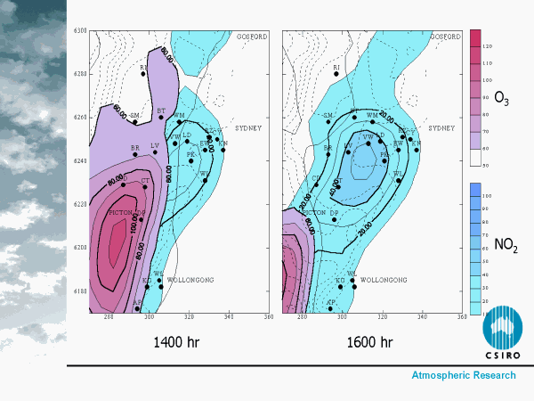
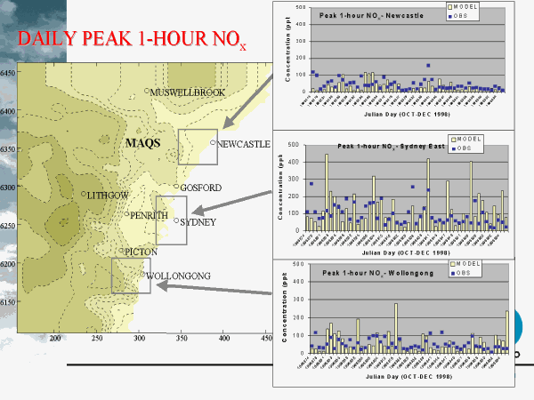
Slide 18 of 27
- Picture of NO2 (blue) and O3 (pink) for 1400 and 1600 hr
- MAQS region. Emissions from Sydney are transported to the southwest in a sea breeze.
High ozone levels occur far downwind.
Slide 19 of 27
- What do you do with the model output?
- Show model performance (gives confidence in regions where there isn’t any data)
- compare with any observations -point for point (time and space), v. tough cf.
(presumably could extract the pollution someone is exposed to hour by hour as
they travel around)
- obs - mod concentration time-series
- obs - mod frequency distributions
- Produce peak concentration fields
- Produce population exposure metrics
- Measures to interpret model concentration fields (metrics which describe the spatial
and temporal extent of exposure)
- peak daily concentration = daily max 1-hour average concentration (in airshed)
- peak dosage = max daily accumulated concentration experienced at a location in
airshed (threshold value - if below this at each hour -don’t include that hour’s
concentration) (integral over time of c(x,y,t))
- simple - population exposure index = max of sum over time of product of c(x,y,t)
and exposed population at (x,y,t) - get cases of large peak dosage within heavily
populated areas. Crude, no account of population age, time-activity or indoor/outdoor
exposure.

Slide 20 of 27
Slide 21 of 27
- Grid resolution 6 km
- Eventually 1 km (air quality) in boxes
- LAPS 24-36 hr (20 min cpu)
- Air pollution off line at present (1 hour cpu)

Slide 22 of 27

Slide 23 of 27
- Ozone air quality metrics for 9/2/94
- (a) max one-hour ozone conc (ppb) ( in 24 hour period)
- (b) dosage (as fraction of maximum base case dosage)
- (c ) population - weighted dosage (as fraction of the max base case population weighted dosage)
- Three different ways of looking at ozone
- max values (hour) - no time accumulation, no people,
- over time - shows where levels are elevated for longest (highest)
- pop x conc - daily exposure, (people standing outside for 24 hours sniffing the
air) (can also weigh by land-use)
- high dosage over rural levels

Slide 24 of 27
Applications
- many urban scale Eulerian models have been used for studies in Australia (Melbourne, Perth, Sydney)
- source sensitivity
- sensitivity of airshed to particular source by running models with and without specific sources
- network design
- use model to predict polluted and non-polluted areas - use this info to site (or move) monitors
- possibility some air pollution monitors are not sampling the most polluted air

Slide 25 of 27
- Applications
- forecasting - Australian Air Quality Forecasting System - under development
(CSIRO AR, CSRIO ET, Bureau, EPA VIC, NSW EPA - with funding from the Air Pollution
in Major Cities Program, run by Environment Australia)
- aim to produce high resolution, met and air quality forecasts for major
urban areas
- photochemical smog, fine particulate matter, air toxics twice daily at
effective resolution of few kms (24 - 32 hour forecasting)
- forecast extreme events

Slide 26 of 27
- Normalized NOx
- (10 - 20% less cars, enough to go from congested to free flowing)

Slide 27 of 27